Investigating the Ocean
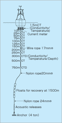
CTD (conductivity (salinity), temperature, depth)
Sensors to Investigate the Ocean at Different Depths
A CTD is an observational instrument to measure the conductivity (salinity), temperature and underwater pressure (depth) of the ocean, electrically.
The instrument is deployed in the ocean connected by cable to observe a vertical profile of the temperature and salinity. This data will be utilized to analyze the characteristics of seawater and current.
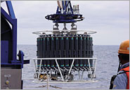
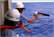
Water Sampler
Sampling and analyzing Seawater
This device is used to collect samples of seawater at various levels in the ocean.
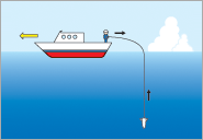
In general, the water sampler is a pipe with lids at both ends. The water samplers with opened lids are lowered into the water until the desired depth is reached. At the desired depth, the lids are closed and the water samplers are raised back onto the vessel. Water samples are analyzed using various equipment on board to precisely determine salinity, carbon dioxide (total carbonate), nutrients and dissolved oxygen. This data will be utilized to analyze the characteristics of seawater and current in conjunction with CTD data.
Acoustic Doppler Current Profiler (ADCP)
Measuring Ocean Currents with Acoustic Waves
Acoustic waves, emitted from an Acoustic Doppler Current Profiler (ADCP) into the ocean, are reflected by drifting particles, plankton, and other objects present in seawater. The direction and speed of ocean currents at a particular depth can be detected by acoustic Doppler shift from receiving reflected acoustic waves. There are various types of ADCPs available for different purposes, such as devices that can be moored in the ocean, those that can be lowered from a ship via a cable in a fashion similar to water samplers, and those that are attached to the bottom of a ship's hull in order to perform surveys over wide areas while the vessel is moving.
eXpendable Bathy Thermograph/eXpendable CTD (XBT/XCTD)
Sensors to provide Instant Seawater Observations
Although there are times when ocean surveys are performed at a set location, it is more efficient to perform them while cruising. XBTs (eXpendable Bathythermographs) and XCTDs (eXpendable Conductivity, Temperature and Depth) include probes composed of a canister and sensors. The devices are dropped from a ship, and determine temperature for XBT (temperature and salinity for XCTD) using the attached sensors in the same way as CTD. Once deployed in the ocean, depth of probe is determined based on an empirical formula which assumes a probe free-fall during measurement. As their names suggest, the probes are expendable and do not have to be recovered. They therefore have the advantage of facilitating surveys while cruising along or in rough weather.
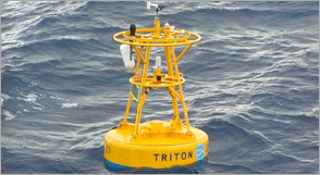
TRITON buoy
Atmospheric and Oceanic Observation in the Pacific and Indian Oceans
The TRITON array (Triangle Trans-Ocean Buoy Network) is a network of observational buoys and is deployed in the western tropical Pacific and eastern Indian Oceans for the purpose of understanding the phenomena of climate variability, such as El Nino in the Pacific Ocean, Indian Ocean Dipole Mode, and the Asian Monsoon. TRITON buoys observe wind, air temperature, humidity, air pressure, precipitation, solar radiation, and ocean currents, as well as water temperature and salinity to a depth of 750 m. The data is transmitted via satellite in real-time, and provided to researchers around the world, and is also utilized by operational meteorological agencies in a world for daily weather forecasts. Meteological/oceanographic data were collected at a total of 18 spots in tropical Pacific Ocean and Eastern Indian Ocean.
Argo Floats
Observation by drifting floats
Argo is an international project, of which the aim is to build a real-time, high resolution monitoring system for upper and middle layers of the world ocean by deploying approximately 3,500 automatic drifting profiling floats, called Argo floats, into the world ocean.
An Argo float basically drifts at a depth of 1,000 m. Every 10 days, it goes down to 2,000 m and then ascends to the surface measuring temperature, salinity, and pressure profiles. At the surface, it sends the observed data to users via a satellite, and then goes down again to 1,000 m. Each Argo float repeats this observation cycle for about 4 years.
Deploying an Argo float every 300 km square makes possible the real-time monitoring of the global ocean conditions. This will greatly contribute to understanding interannual, decadal and interdecadal variations of the climate system, and also bring in a substantial improvement in the performance of long-term forecast.
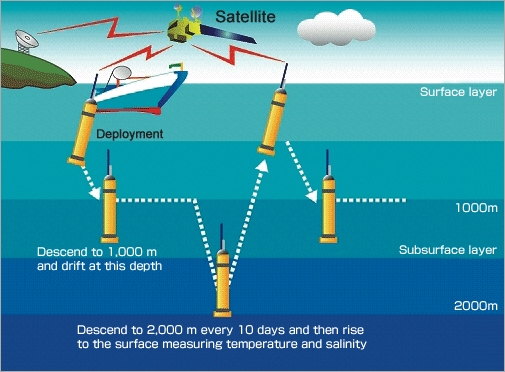
Argo floats measure temperature and salinity profiles from 2,000 m up to the surface every 10 days, and then transmit the observed data to land-based facilities via satellites.
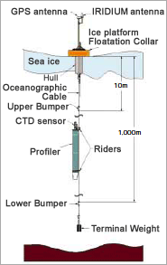
POPS
Investigating changes of the Arctic Ocean
The Polar Ocean Profiling System (POPS) is an observation system using Argo floats and it was developed for the observations in the Arctic Ocean. A platform for POPS is installed on sea ice and a cable equipped with Argo floats is dropped into the ocean. The float measures water temperature, salinity, and pressure in the range of 10 m and 1,000 m depth.
Arctic ice is currently disappearing at a rate of more than 8% every 10 years, and detailed observation data is required in order to investigate the causes of this rapid change and the climatological role of the Arctic Ocean.
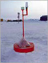
The platform moves around with the ice.