Deep Ocean Floor Survey System
DEEP TOW
Overview
DEEP TOW is a deep ocean floor survey system that can be outfitted with sonar or cameras and towed through the water at low speeds at the end of a cable measuring several thousand meters in length. There are three systems available: a system installed on the research vessel YOKOSUKA, a system for a 6,000-meter class camera, and a system for a 6,000-meter class sonar.
Systems
(1) Camera systems
- YOKOSUKA DEEP TOW (YKDT)
YKDT is a camera system installed on R/V YOKOSUKA to perform preliminary surveys for the manned research submersible SHINKAI 6500. Its maximum towing depth is 6,000 meters. YKDT is equipped with a high-definition camera which allows images of the ocean floor to be observed in real time. It also can install instruments on the seabed using a release device. Sampling with a small dredge is occasionally carried out while viewing the camera image. - 6K Camera DEEP TOW (6KCDT)
The maximum towing depth is 6,000 meters. 6KCDT is equipped with a 3CCD camera which allows images of the ocean floor to be observed in real time. It also can install instruments on the seabed using a release device. Sampling with a small dredge is occasionally carried out while viewing the camera image.
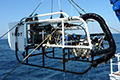
YOKOSUKA DEEP TOW
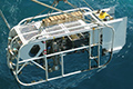
6K Camera DEEP TOW
(2) Sonar system
- 6K Sonar DEEP TOW (6KSDT)
The maximum towing depth is 6,000 meters. 6KSDT is equipped with a side scan sonar system to provide detailed information on the ocean floor topography. It can serve as a camera system if a high-definition camera and LED lights are mounted for ocean-floor observation, upon request.
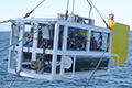
6K Sonar DEEP TOW
Principal specifications
(1) Camera systems
YOKOSUKA DEEP TOW (YKDT)
6K Camera DEEP TOW (6KCDT)
(2) Sonar system
6K Sonar DEEP TOW (6KSDT)
History of DEEP TOW
- Dec 1999Discovered the main engine of the H-II Rocket Flight No. 8 during the second cruise to search its first stage rocket engine.
- Jan-Feb 1997Found the body of the Nakhodka, a Russian sunken oil tanker, during the search operation.
- Aug 1993Surveyed the focal region of the earthquake which occurred southwest of Hokkaido in July 1993.
- Sep 1989Surveyed the focal region shortly after a swarm of undersea earthquakes off the coast of Ito, Shizuoka Prefecture.
- Aug 1988Discovered hydrothermal communities on the Minami-Ensei Knoll of the Okinawa Trough.
- Jul 1988Discovered hydrothermal activities at the Iheya Ridge in the Okinawa Trough.
- May 1988Discovered hydrothermal communities on the Kaikata Seamount in the Izu-Ogasawara Arc.
- Dec 1987Discovered hydrothermal activities during the study on the rift system of the North Fiji Basin in the STARMER Japanese-French Joint Project.
- Nov 1986Surveyed the Suda Trench in Indonesia.
- Nov 1985Searched the missing tail fin of the crashed Japan Airlines airliner in the Sagami Bay.
- Nov 1984Surveyed the Tonga Trench.
- Oct 1983Surveyed the focal region of the earthquake which occurred off the coast of Akita Prefecture in the Sea of Japan in May 1983, and discovered open cracks, vents, and differently-colored areas on the seabed.