November 11, 2011
JAMSTEC
JAMSTEC Develops High-performance, Compact Inertial Navigation System
1. Overview
Shojiro Ishibashi and his colleagues at JAMSTEC have successfully developed a compact inertial navigation system (INS) for use on underwater vehicles, which is capable of providing highly accurate information for autonomous navigation (Fig.1).
Composed of a ring laser gyro module and state-of-the-art electronics, the new INS can continuously supply information indispensable to navigate the underwater vehicle (e.g. position, altitude, orientation and velocity). It achieved the highest levels of performance in the world in its size and class. A host of new functions equipped in the INS, including multiple methods for navigational calculation and motion-based alignment, are also expected to help enhance the performance of underwater vehicles.
An INS is one of key technologies that govern the navigational ability of underwater vehicles. Yet, in many countries, researchers have to rely on products from particular oversea brands. Against this backdrop, researchers at JAMSTEC and Japan Aviation Electronics Industry Inc. joined their and technological expertise to develop the nation's first, high-performance compact INS.
2. Development chronology
| April 2004 | Element studies for the new INS began as a national critical technology |
| March 2008 | Completion of the first prototype INS (Fig. 2) |
| August 2009 | Following technical verification tests with the prototype, the development of an INS for use on underwater vehicles (on-board model) began |
| September 2011 | Completion of building the new INS on-board model |
| November 2011 | Functional and performance tests (Integration tests) of the new INS. The new INS is to be mounted on underwater vehicles being developed at JAMSTEC. |
3. Specifications
| <Prototype> | <On-board model> | |
| Dimensions | 185mm×185mm×240mm | 168.5mm×168.5mm×159.0mm |
| Weight | 8.5kg | 6.4kg |
| Positional accuracy* | 0.7 Nm/hr CEP | 0.5 Nm/hr CEP |
| *No aiding *Nm/hr: Nautical Mile (=1,852m)/hr *CEP: Circular Error Probable |
<New functions>**
·GPS/DVL/ APS hybrid positioning
The function enables highly precise calculations by combining the outputs from GPS (Global Positioning System), DVL (Doppler Velocity Log) and APS (Acoustic Positioning System). It compensates positional accuracy error to provide a safe and smooth navigation over rough seafloor terrains.
·DVL dead reckoning output
It allows for accurate calculation of navigation signals using the INS's current position and DVL velocity. It is especially effective in conditions in which the compensation of DVL error is available.
·Land/on-board/seafloor /store heading alignment
This function performs an initial alignment of an INS on land, on a ship or on the seafloor. A store heading alignment takes one minute at the quickest.
·Sensor raw data output
This enables the output of measurements from each sensor prior to inertial navigation data processing. The function is useful when a user wants to design and use his/her own navigation algorism.
·Hybrid parameter control
During hybrid navigation, this function dynamically sets internal parameter calculations in each navigation mode. It allows a hybrid system to be versatile and adaptable to different types and performance of onboard sensors.
** The first application to INSs made in Japan.
Other functions:
·Automatic / manual Transition/modification
·Misalignment adjustment
·GPS/DVL/ APS alignment
·Alignment time setup
·Change of communication rate
·Compensation for instantaneous interruption
4. Future plans
The new INS is to be carried aboard autonomous and remotely operated underwater vehicles (AUVs/ROV), which are being developed at JAMSTEC and expected to facilitate the exploration of marine resources and subsea environment monitoring. Alongside the development of this new AUV, link tests of the AUV's control system are also underway (Fig. 3). At-sea tests of the AUV and INS are scheduled to be held in spring 2012. With dimensions mountable onto small-sized underwater crafts, as well as lightweight, high performance, multifunctional features, the newly developed INS holds promise as an important tool in detecting the position of a moving object without the aid of external references. The new INS will therefore be in use not only for underwater applications but also for other moving platforms, such aircrafts or test trains.
*1 Inertial Navigation System: INS
An INS is a device that detects angular speed and liner acceleration of a moving object by using gyroscopes and accelerometers. The data from these sensors are used to calculate an absolute position of the moving object. In underwater navigation, an INS controls the position and direction of the underwater vehicle, keeping it on course toward the target.
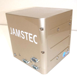
Figure 1. High-performance inertial navigation system (INS)
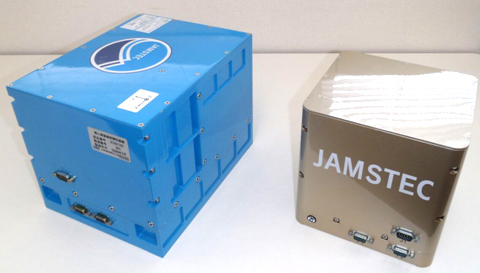
Figure 2. High-performance INS: prototype (left) and working
The high-performance INS was developed through technological innovations and research achievements having made at JAMSTEC. Based on the results from technological verification testing of the prototype, new functions, including a ring laser gyro modular, were added to the working model.
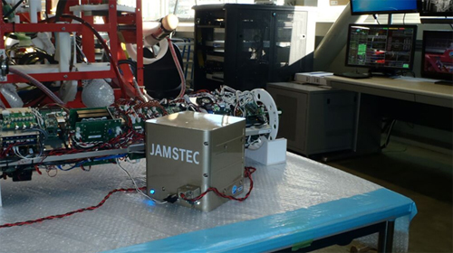
Figure 3. Link tests with the vehicle's control system
Contacts:
- Japan Agency for Marine-Earth Science and Technology
(For INS) -
Shojiro Ishibashi, Research Scientist
Underwater Vehicle Technology Group
Marine Technology Development Department
Marine Technology and Engineering Center (MARITEC)
- (For publication)
-
Hikaru Okutsu, e-mail: press@jamstec.go.jp
Senior Administrative Specialist, Planning Department Press Office