Extreme Event Projection
Will tropical cyclones and heavy rainfall in the East Asian rainy season cause more natural disasters?
Projection of the change in future weather extremes using super-high-resolution atmospheric models
- What is our target and how do we accomplish it?
We will perform climate projections for the near future and for the end of the 21st century using atmospheric models of unprecedented super-high-resolution. The climate change studies will be based on a global 20-km mesh atmospheric general circulation model; emphasis will be placed on extreme events, including tropical cyclones and heavy precipitation during the East Asian summer monsoon season. The multi-model ensemble of sea surface temperatures (SSTs) projected by atmosphere-ocean general circulation models (AOGCMs) used in the IPCC Fourth Assessment Report (AR4) will be input to the global 20-km mesh atmospheric model to obtain the future climate projection (time-slice experiment). Furthermore, in a focus on local climate change over Japan, 5-km and 1-km mesh regional atmospheric models embedded in the global model will be used to investigate changes in heavy precipitation. Much literature has already been published to describe our super-high-resolution atmospheric model; these reports are cited in the IPCC's AR4. The uncertainty of the projected climate change will be evaluated and quantified using multiple sets of ensemble experiments to provide information on the reliability of the model outcomes. Using data computed from the model projections, environmental changes that may lead to disasters such as landslides, debris flows, floods, droughts, storm surges, and strong winds will be evaluated for Japan. The climate-change impacts on river planning in Japan will be also assessed. Moreover, flood risk assessment will be extended to a global scale for cooperation with international projects on disaster mitigation.
- Will tropical cyclones (TCs) intensify?
Figure 1 shows the global change in TC intensity as a function of surface maximum wind. The IPCC A1B scenario was assumed for the future climate simulation. The frequency of intense TCs will increase in a future warmer climate, suggesting that the risk of natural disasters will also increase.
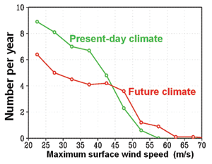
Fig1. Frequency distribution of surface maximum wind of TC for the present climate at the end of 20th century and future climate simulations at the end of 21st century.
- What changes will occur in rain bands (Baiu/Meiyu/Changma frontal precipitation systems) of the East Asian summer monsoon?
Changes in the precipitation characteristics of rain bands during the East Asian summer monsoon season have been investigated. This research suggests that total precipitation from June to July will increase over the Yangtze River valley, the East China Sea, and western Japan, but decrease over Korea, Taiwan, and northern Japan. Heavy precipitation will increase over the Yangtze River valley, the East China Sea, and western Japan, increasing the risk of natural disasters in these regions.
Quantification and reduction of the uncertainty in climate change projection by super-highresolution atmospheric models
- Will the number of typhoons and hurricanes increase? Is the answer certain?
Figure 2 shows the projected change in the number of typhoons and hurricanes. Future simulations depend on the SST provided to the atmospheric model because the atmosphere is greatly affected by the SST underneath. There appears to be no consensus among researchers on projected changes in the number of typhoons and hurricanes. The quantification of future changes in the number of TCs is one of the challenges especially emphasized in the IPCC's AR4.
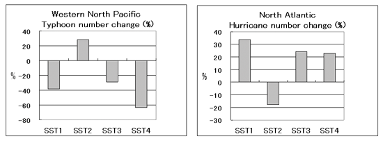
Fig2. Change in annual number of TCs at the end of 21st century relative to present climatology (%).Horizontal axis denotes experiment type in which the geographical distributions of SST are different. Left: Typhoon. Right: Hurricane.
Integrated assessment of climate change impacts on watersheds in a disaster environment
- How will floods in Japan change?
Figure 3 shows an example from a pilot study of possible changes in the number of floods requiring dam operation and emergency dam release. Precipitation and evapotranspiration data included in the Japanese Standard Climate Scenario ver. 2 (2004), provided by the Japan Meteorology Agency (JMA), were input to a high-resolution distributed hydrological model, which was used to assess the Yodo River basin in Japan. The number of severe floods is predicted to increase, suggesting an increased risk of flooding caused by heavy rainfalls.
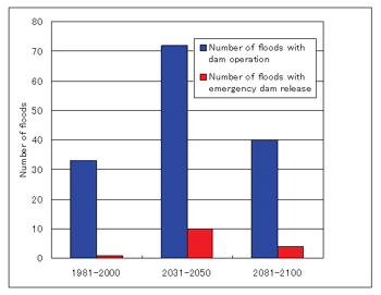
Fig3. Changes in the number of floods which cause dam operation and emergency dam release in a dam reservoir during 1981 to 2000, 2031 to 2050, and 2081 to 2100, respectively.
Assessment of the impact of climate change on flood disaster risk and its reduction measures over the globe and specific vulnerable areas
- How will the worldwide flood risk change in the future?
Although various flood risk maps are available, the data used to make these maps contain numerous uncertainties, including uncertainty regarding the magnitude of flood hazard. This research will clarify the current and future status of flood hazards quantitatively by combining advanced AGCM outputs, state-of-the-art hydrological models, and socioeconomic databases. The outputs will be used to produce a quantitative map of flood risk under conditions of climate change. To accomplish this goal, the available information must be examined. There are some of the technical issues to be solved such as differences in temporal and spatial scales between AGCM simulations and ground-based observations. Current AGCMs tend to produce weaker and longer-duration precipitation relative to observations. Considering the reproducibility of precipitation by AGCMs in the present climate, we will develop an engineering model for the future climate projection.