♦Aims
With the cooperation of the Department of Meteorology, the Republic of Maldives,
we deploy the three observation sites in Maldives; Gan Island, Hulhule Island,
and Kadhdhoo Island. The sites in Maldives and R/V "Mirai" constitute the observation network
to capture the spatial (especially horizontal) structure of the precipitating systems and
their environmental situations. This observation network is expected to reveal the MJO convective systems,
as below:
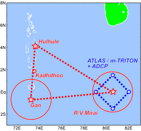
-- Zonal Line over Equator: "Mirai" and Gan Island
The MJO moves eastward along the equator with developping. This zonal line over equator could capture
the zonal structure, movement and development of MJO. The sophiscated instruments are concentrated
at "Mirai" and Gan Island for this line.
-- Meridional Line: Gan, Kadhdhoo and Hulhule
The disturbance within MJO have characteristic meridional (north-south) structure.
The structure of the disturbance could be captured by these sites, deployed along 73E from Equator to 5N.
-- Budget Analyses Area: "Mirai", Gan, and Hulhule
These three sites will launch the radiosonde. By calculating the budget of the water (vapor, ice, cloud, rain, ...)
and heat energy forthe enclosed area by these three sites, the impact of the preciptating systems to the large-scale
atmosphere could be revealed.
♦Instruments
- Hulhule Island (4.2N, 73.5E)
Automatic Weather Station (AWS)
GPS receiver
Radiosonde
- Kadhdhoo Island (1.9N, 73.5E)
AWS
GPS receiver
- Gan Island (0.7S, 73.2E)
AWS
GPS receiver
Radiosonde
Doppler Radar
Ceilometer
Disdrometer
Microwave Radiometer
Doppler Sodar
Sky View Camera