Subduction Dynamics Research Center (SDR)
Toward understanding the seismogenic zones from marine geophysical and geological surveys and observations
We conduct extensive marine controlled-source seismic surveys and earthquake observations to reveal the subseafloor structure in subduction seismogenic zones, especially focusing on the detailed geometry and physical properties of the megathrust plate boundary fault. We also apply submarine paleoseismology using seafloor sediment samples to reveal the prehistoric huge earthquakes and tsunami in subduction zones. Based on these activities, we will contribute to a better understanding of the subduction seismogenic zones.
- 2023/09/20
- Discovery of fluid conduits that extend from the plate boundary fault hosting slow earthquakes to the seafloor
- Successful imaging of the upper-plate fracture zones formed by a subducting ridge - - 2021/07/16
- Marine Geology and Geophysics Research Group, Recruitment of Researcher (Ⅱ) (CKS21-001)
- 2021/06/03
- Marine Seismology Research Group, Recruitment of Postdoctoral Researcher CGP21-002
- 2021/02/09
- Marine Geology and Geophysics Research Group, Recruitment of Researcher (Ⅱ) CKS21-001
- 2020/07/06
- FY2020 Marine Seismology Research Group, Recruitment of Project Researcher (Ⅱ) CGS20-005
- 2020/04/02
- Petit-Spot Volcanoes May Have Determined the Northern Limit of the 2011 Tohoku
Earthquake: Discovery of Heterogeneity in Subducting Oceanic Plates Offshore of Tohoku - 2019/10/30
- FY2020 Marine Seismology Research Group,Subduction Dynamics Research Center (SDR), Research Institute for Marine Geodynamics(IMG) Recruitment of Scientist or Technical Scientist (CKS-004)
- 2019/05/27
- Subduction Dynamics Research Center (SDR) website has been launched.
Visualization of seismogenic zones
In the subduction seismogenic zones, both the normal earthquakes, that cause strong ground motion, and the so-called slow earthquakes, that cause almost no ground shaking, occur along the plate boundary fault. The conditions that discriminate the generation of the normal earthquakes and slow earthquakes are still poorly understood. Clarifying these conditions is key to understanding the generation mechanism of various earthquake along the plate boundary fault.
The Subduction Dynamics Research Center (SDR) conducts extensive marine controlled-source seismic surveys and seafloor seismic observations to better understand the subduction seismogenic zones. One of the primary research objectives is revealing the conditions that discriminate the occurrence of the normal and of the slow earthquakes. Recently, we confirmed that slow earthquakes occur along the plate boundary fault where many small seamounts are subducting. In addition, we found a narrow low seismic velocity zone, suggesting highly fractured zone, within the overlying plate between the areas of the normal earthquakes and of the slow earthquakes, suggesting that the structural evolution of the overlying plate is closely related to the seismic activities along the plate boundary faults. We will further investigate the physical properties of the low velocity zone to better understand the causes that discriminate the areas of the normal earthquakes and of the slow earthquakes, and the mechanism that enables the devastating plate boundary earthquakes.
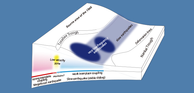
Schematic illustration of the subduction seismogenic zone of the Central Nankai Trough, showing a low velocity zone exists within the overlying plate between the areas of the megathrust earthquakes (strong interplate coupling) and of the slow earthquakes (weak interplate coupling).
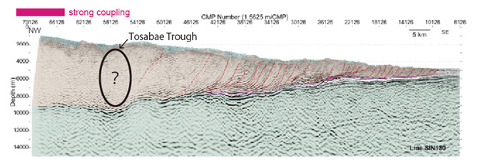
Seismic cross-section of the Central Nankai Trough. A low velocity zone exists beneath the Tosabae Trough.
Challenges for Monitoring subseafloor structural changes
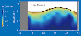 S-wave velocity structure estimated by the ambient noise analysis observed through the fiber-optic cable off Cape Muroto.
Long-term Submarine seismic observation has many difficulties, such as the cost of the installation and the constant power supply. However, the recent development of new observation technology that uses submarine fiber-optic cables, which are commonly used for telephone and Internet communications, as sensors to detect ground motion is bringing significant innovation to submarine seismic observations. Research and Development Center for Earthquake and Tsunami Forecasting(FEAT) succeeded in developing a seismic monitoring system that uses an existing seafloor cable several tens of kilometers long off Cape Muroto. The monitoring system is equivalent to a dense and permanent array of the ocean bottom seismometers installed at several meter intervals.
We, Subduction Dynamics Research Center (SDR), processed the ambient noise of the data obtained through the fiber optic cable off Cape Muroto and have succeeded in extracting various seismic waves propagating under the seafloor. In addition, we have developed a new technique to visualize the complicated geological structure beneath the seafloor using the seismic waves extracted from the ambient noise observed by the fiber-optic cable. These new observation and analysis techniques have the potential to detect changes in the subseafloor structure under the existing fiber-optic cables. We will advance our observation and data analysis techniques to monitor the minute changes that occur in the subduction seismogenic zones.
Paleoseismology: Exploring prehistoric giant earthquake and tsunami
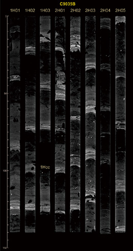 X-ray CT images of a core sample taken from the Nankai Trough.
The images show repeated appearance of turbidites (white bands).
The 2011 Tohoku earthquake was the largest earthquake instrumentally recorded in Japan and caused a devastating tsunami. A large tsunami inundation similar to the 2011 Tohoku earthquake is recorded in historical documents, but the recurrence of such devastating earthquakes and tsunamis is poorly understood. Marine paleoseismology, a study of prehistoric giant earthquakes and tsunamis based on the traces left by these events, is key to understanding the geohazard and risk posed by long-recurrence earthquakes.
When the seafloor is strongly shaken by earthquakes, the sediments suspended by the strong ground motion move down the slope like an avalanche, reaching the deep seafloor and depositing there, forming a layer called "turbidites". Since the turbidites layers are the traces of past earthquakes and tsunamis, the seafloor sediments sampled by coring are the key to paleoseismology. The distribution of the turbidites show the extent of strong ground motion at the seafloor.
In the Japan Trench, we succeeded in determining the extent of the strong ground motion from the paleoearthquake that occurred more than 1000 years ago, based on the sediment samples taken from the seafloor. In the Nankai Trough, we found many turbidite layers in the sediment cores, but some of them may not be related to strong ground motion. Therefore, we will develop a method to distinguish the cause of the turbidite layer formation and will reveal the historical occurrence of earthquakes and tsunamis in this area.
We will continue to conduct deep seafloor surveys and core sampling, and reconstruct earthquake occurrence records up to tens of thousands of years in the past, mainly in the Nankai Trough, Japan Trench, and Kuril Trench areas.
Gou Fujie
Director of Center
Specialty: Marine Seismology
Most of the devastating earthquakes, such as the 2011 Tohoku earthquake, occur beneath the seafloor. To clarify the detailed nature of such seismogenic zone, in-situ observations where the earthquakes occur are indispensable. We challenge to understand the past, present, and future state of seismogenic zones based on marine geophysical and geological surveys and observations.