G-YoMaHa (Objectively mapped velocity at 1000 dbar derived from trajectories of Argo floats)
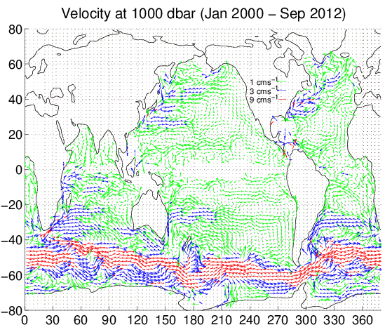
We mapped the drift data from the Argo floats, YoMaHa'07 (version September 2012), at the depth of 1000 dbar (approximately 1000 m) on a 1 degree grid. The mapping method is statistically optimal. The mapped velocity field satisfies the geostrophic balance and the horizontal boundary condition of no flow through the boundary.
Data set
Prior to the March 2012 version, the eastward velocity and its uncertainty had significant errors owing to a bug in the geostrophic calculation. Please use the versions released after Jan 2012.- Document
- Katsumata, K., H. Yoshinari, 2010, Uncertainties in global mapping of Argo drift data at the parking level, Journal of Oceanography, 66, 553-569
- From the September 2010 version, the Ekman transport is considered when inter-landmass transports are estimated (Table 1 in Document).
- The wind stress is the average from 2000 to 2009 of NCEP2 reanalysis.
- Format
- Ascii text compressed by gzip and netCDF.
- In the Ascii format, the columns are, from left to right,Longitude (degree), Latitude (degree), Geostrophic pressure (Pa), Geostrophic pressure uncertainty (Pa), Eastward velocity (m/s), Northward velocity (m/s), Eastward velocity uncertainty (m/s), Northward velocity uncertainty (m/s)Missing values are indicated by 99999.
- Product
- mean_vel_1000.dat.gz [Ascii text: 808KB]
- mean_vel_1000.nc [netCDF: 2788KB]
- Conditions of Use
- We do not restrict private, educational, and academic use of the Product. We request acknowledgement of the above Document as the source of the Product when results of the Product are published.
- This Product is for private, educational and academic use only. Commercial use, redistribution, or modification is prohibited without the prior written consent of ours.
- We endeavour to make the Product scientifically accurate, but we shall not be liable for any loss or damage howsoever arising as a result of the use of the Product.
- Citation: Katsuro Katsumata (2011) G-YoMaHa (Objectively mapped velocity at 1000 dbar derived from trajectories of Argo floats). JAMSTEC. doi:10.17596/0000103
- Example plot
contact: