July 30, 2009
Japan Agency for Marine-Earth Science and Technology
Integrated Ocean Drilling Program (IODP)
Nankai Trough Seismogenic Zone Experiment (NanTroSEIZE)
Expedition 319
CHIKYU Reports Successful Completion of Riser Drilling Operations
1. Overview
The deep-sea drilling vessel CHIKYU, operated by the Japan Agency for Marine-Earth Science and Technology (JAMSTEC: Yasuhiro Kato, President), is engaged in the IODP Expedition 319 for Stage 2 of the Nankai Trough Seismogenic Zone Experiment (NanTroSEIZE)(*1), in the Kumano Basin, off the Kii Peninsula. The expedition team is taking on the challenge of drilling deep into and sampling the upper portion of the great earthquake zone to gain insights into geological formations and stress-strain characteristics. The drilling and coring operations in the Kumano Basin began on May 12th; the team is expected to complete the first drill site around August 1st.
2. Operation summary of first drill site of Expedition 319
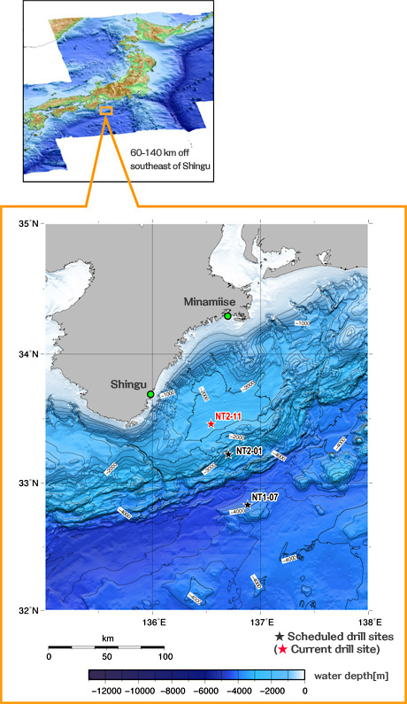
Under harsh weather and ocean conditions and complex geological characteristics of the drill site, the CHIKYU attempted the first riser drilling(*2) in the history of scientific ocean drilling, and successfully drilled down to a depth of 1,603.7 meters beneath the sea floor at the site NT2-11 (at water depth of 2,054 meters, Fig. 1).
Summary of operations and achievements:
(1) Measurement While Drilling (MWD) was carried out to a depth of 1,510 meters beneath the sea floor to obtain real-time geophysical characteristics including borehole gradient and direction, borehole pressure, and natural gamma ray. In MWD, sensors attached near the drill bit measure geophysical properties while drilling.
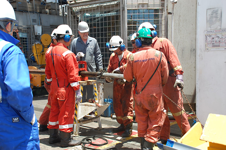
(2) Riser drilling was employed from about 700 meters below sea floor to the bottom of the hole. Cuttings were recovered on board from circulated drilling fluid and analyzed to gain a better overall picture of downhole changes in lithology and age. Core sample were also collected between depths of 1,510 and 1,593.3 meters below the seafloor. Riser drilling involves the circulation of drilling fluid that helps maintain pressure balance within the borehole (Photo 1).
(3) Following the drilling, wireline logging instruments were lowered into the borehole using a cable to measure temperature and resistivity of fluid, resistivity of formation, borehole diameter, porosity, density, gamma ray, water pressure and rock permeability, as well as magnitude of stress and strength of geological formation.
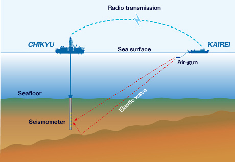
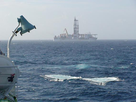
(4) Vertical Seismic Profiling was conducted on July 24 to July25 and successfully obtained accurate details of the geological structure of the plate boundary system and the accretionary prism. The experiment involved an array of 16 seismographs vertically lowered into the borehole and 8 ocean-bottom seismographs placed on the seafloor. An air-gun array on the JAMSTEC research vessel KAIREI generated elastic waves, which traveled through the formation to be recorded on the borehole and seafloor instruments (Fig. 2 and Photo 2).
3. Future schedule
The operations at this drill site are expected to conclude around August 1st, after casing the borehole to the bottom of the hole and capping it with a corrosion cap for future installation of a Long-Term Borehole Monitoring System (LTBMS). After completion of this task, the CHIKYU will move to its next drill site: NT2-01 (Fig. 1), where riserless drilling will be employed to penetrate the shallower portion of the megasplay fault branching from the seismogenic zone. Logging While Drilling (LWD) will be conducted to measure rock properties, geological formation, and geophysical characteristics of the area. As a preliminary operation for the Long-Term Borehole Monitoring System scheduled in the future, observatory instruments will be installed inside the borehole to measure temperature and pressure over the next few years.
Further analyses by scientists are expected to generate significant scientific knowledge of past earthquake activities and development processes of the Nankai Trough accretionary prism, as well as the mechanism of occurrence of large earthquakes and tsunamis.
The daily reports, photos and video from the CHIKYU are available online at:
http://www.jamstec.go.jp/chikyu/eng/Expedition/NantroSEIZE/special.html
The above schedule is subject to change depending on the progress of drilling operation and weather.
*1. The Integrated Ocean Drilling Program (IODP) is an international marine research drilling program dedicated to advancing scientific understanding of Earth by monitoring, sampling, and instrumenting subseafloor environments. Through multiple platforms, preeminent scientists explore IODP principal themes: the deep biosphere, environmental change, and solid Earth cycles. IODP has operated since October 2003, funded jointly by the Japan Ministry of Education, Culture, Sports, Science and Technology and the U.S. National Science Foundation; with additional support provided by the European Consortium of Ocean Research Drilling; the People's Republic of China, the Republic of Korea, Australia, India, and New Zealand.
*2 Riser drilling involves a large marine riser pipe that connects the CHIKYU and the seafloor. The riser pipe guides the drill pipe as it reenters the well. Drilling fluid is pumped up and down between the riser pipe and the drill pipe. Fluid circulation and use of the blow-out preventer (BOP) help maintain pressure balance within the borehole and prevent it from collapsing, enabling safer and deeper drilling.
- Figure 1: Map of study area and drilling Sites
- Figure 2: Schematic sketch of VSP at NT2-11
- Photo 1: Geological core samples are recovered from the core barrel.
- Photo 2: R/V KAIREI shoots the air gun for the vertical seismic profiling experiment with the CHIKYU.
Contacts:
- (For the expeditions)
-
Yasuo Yamada, e-mail: cdex@jamstec.go.jp
Manager, Planning and Coordination Department
Center for Deep Earth Exploration (CDEX)
Japan Agency for Marine-Earth Science and Technology
- (For Publication)
-
Toru Nakamura, e-mail: press@jamstec.go.jp
Manager, Planning Department Press Office
Japan Agency for Marine-Earth Science and Technology