August 6, 2009
Japan Agency for Marine-Earth Science and Technology
Worlds First: Innovative Beam-Steering Synthetic Aperture Sonar Proves High Performance at Sea
- Enhancing Efficient Ocean Surveys and Homegrown Technology Development -
1. Overview
Takao Sawa and his team at the Marine Technology Center, the Japan Agency for Marine-Earth Science and Technology (JAMSTEC: Yasuhiro Kato), has developed a new synthetic aperture sonar (SAS) with beam steering capability, which can provide geological details of large swaths of the seafloor. A sea trial of the SAS mounted on JAMSTECS Autonomous Underwater Vehicle (AUV) URASHIMA, successfully delivered clear acoustic imagery(*1) of the deep ocean floor, the worlds first achievement of this kind exploiting beam steering technology.
Comprised of all Japanese components and software, the new SAS is a high-end next-generation sonar system combining innovative signal processing and motion-compensation techniques with a synthetic aperture technique (Fig. 1). It can allow for the production of higher-resolution and reliable sonar images much less affected by the platform motion and operation noise, and thus is expected to help increase the accuracy of ocean surveys.
2. Background
With conventional sonar systems, the resolution of the sonar images deteriorates as the ranges to a target increase, and becomes more susceptible to noise, highlighting the shortcomings of long-range sonar imaging.
To compensate for this, an increase in the physical size of the antenna to narrow its beam width, as well as the operation of sonar sensors close to the target was a necessity. However, it was not technically feasible to attach and operate a large antenna on the underwater vehicle (e.g. AUV); and operating the underwater vehicle in close proximity to the target in deeper water was also not straightforward.
In order to overcome these limitations and attain higher-resolution sonar imaging, the team has applied synthetic aperture techniques to the sonar system. Despite its high performance confirmed by laboratory-based experiments including water tank trials, the images produced by the new sonar were found to be distorted by large amplitude motions of the platform, caused by ocean waves and currents. Furthermore, higher-resolution imaging resulted in a considerably long signal processing time, due to the amount of computation increasing exponentially with the resolution.
3. Development of beam steering synthetic aperture sonar
The motion-compensation technique, which was developed taking wave periodicity into account and thus making it possible to deal with large-amplitude motions, has overcome these problems. Furthermore, a newly developed algorithm has achieved high-speed data processing, dozens of times faster than conventional processing. Both techniques are patent pending.
Using these technologies, acoustic beams can be steered in desired directions (the technology called beam steering, *2), allowing for further enhancements to sonar imaging.
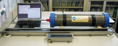
The new sonar system is made up of exclusively Japanese hardware and software (Photo 1).
4. Experiment results
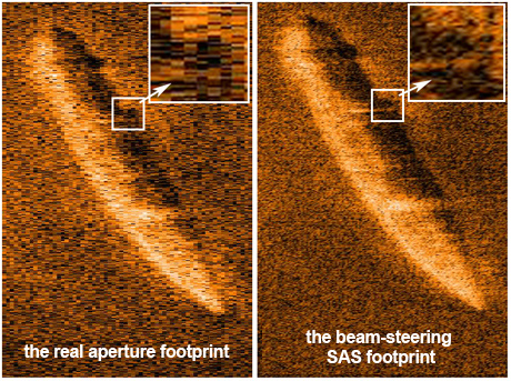
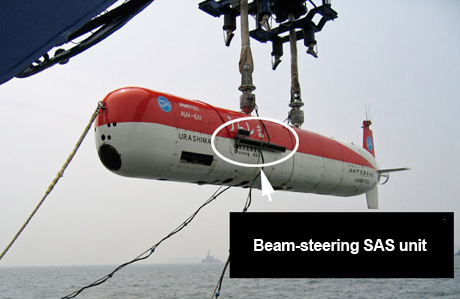
The beam-steering SAS was mounted on the AUV URASHIMA (Photo. 2) and tested at a depth of approximately 1,400 meters in Sagami Bay in June 2009. The results showed improved acoustic imagery of the seafloor, approximately 3 times greater in resolution and about one eighth of a reduction in noise compared to existing sonar processing (Fig. 2).
5. Future perspectives
The development of a high-performance sonar system was launched under the Next-generation Deep-sea Exploration Technology project, one of the technological objectives listed in the national critical technologies in Japan. Upon the successful trial at deep sea environments, the new SAS is expected to enhance efficiency in ocean surveys by its greater area coverage and precision.
In addition, the new SAS can record the phase (*3) shift of acoustic waves, which are not possible using conventional sonars. The difference in wave phase suggests the difference in sediment type, making it useful for detecting mineral resources in the seafloor.
JAMSTEC plans to further refine the beam-steering SAS techniques by leveraging the scientific and technological expertise of Japan.
*1. Acoustic imagery
Instead of radio waves that do not propagate in the sea water, acoustic waves are widely used in underwater surveys and communication. Acoustic imagery technique involves acoustic waves being sent from a sonar source toward the ocean floor (transmission beams), and the return echoes reflected from the seafloor (reception beams), which are processed to produce underwater imagery.
*2 Beam steering
Beam steering is a technique to steer radio or acoustic beams in desired angular directions, by delaying the timing of inputs/outputs of individual elements of the array or antenna. The technique allows for the reception of reflected echoes at a desired timing, generating sharp acoustic beams.
*3. Phase
Phase is a term used to describe the characteristics of a wave form. It is measured as an angle in degrees. The displacement and phase of the wave at a particular point in time can provide values of the maximum displacement (or amplitude) of the wave.
-
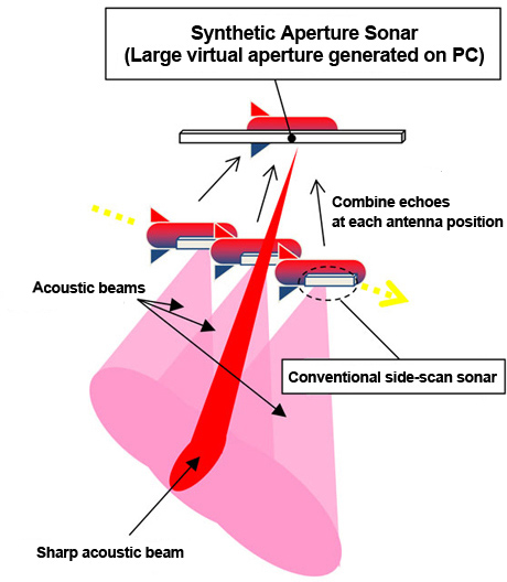
Figure 1: Principle of synthetic aperture sonar
In general, the performance of sonar systems is proportionate to the size of a sonar aperture (or antenna). Large antennas, more specifically, large apertures allow for sharp array beams and increase the resolution. The synthetic aperture sonar (SAS) technique is a method to synthetically generate larger apertures. It involves multiple transmissions of signals from a moving sonar to the same target. The signals reflected by the target are combined and processed on a computer to synthesize a large aperture. This virtual aperture can produce sharp acoustic beams, allowing for higher resolution and noise mitigation.
-
Figure 2: Sonar images of a sunken vessel
The real aperture footprint (left) is blurry. In contrast, the beam-steering SAS footprint (right) depicts a clear image of the sunken vessel, with fine pixels and reduced noise.
-
Photo 1: Beam-steering SAS system
Transmission antenna (bottom), receiver antenna (center), underwater electric device unit (top right), and onboard control unit (top left)
antenna length:1.5 m, weight in water : 40kg
- Photo 2: Beam-steering SAS unit (the black rectangular object) mounted on the Autonomous Underwater Vehicle URASHIMA (the vehicle in red and white).
Contacts:
- Japan Agency for Marine-Earth Science and Technology
(For the study) -
Takao Sawa
Research Scientist, Advanced Deep-sea Robot R&D Group
Advanced Marine Technology Research Program
Marine Technology Center (MARITEC)
- (For Publication)
-
Toru Nakamura, e-mail: press@jamstec.go.jp
Manager, Planning Department Press Office