October 22、2010
Japan Agency for Marine-Earth Science and Technology
Integrated Ocean Drilling Program (IODP)
CHIKYU to Set Sail for Expedition 332
NanTroSEIZE Stage 2: Riserless Observatory-2
The Deep-Sea Drilling Vessel Chikyu, operated by the Japan Agency for Marine-Earth Science and Technology(JAMSTEC), will embark on the Integrated Ocean Drilling Program(IODP)*1 Expedition 332 NanTroSEIZE Stage 2: Riseless Observatory-2, on 25th October, 2010. The expedition, taking place in the Kumano Basin, off Kii Peninsula, aims to drill into the megasplay fault and install long-term observatories in the drilled holes to clarify the seismogenic mechanism of large earthquakes. Eight scientists from Japan, U.S. and Europe will join on the expedition, including Co-Chief Scientist Dr. Eiichiro Araki and observatory specialists.
*1. The Integrated Ocean Drilling Program (IODP) is an international marine research drilling program dedicated to advancing scientific understanding of Earth by monitoring, and sampling subseafloor environments. Through multiple platforms, scientists explore IODP principal themes: the deep biosphere, environmental change, and solid Earth cycles. IODP has operated since October 2003, funded jointly by the Japan Ministry of Education, Culture, Sports, Science and Technology and the U.S. National Science Foundation. Additional support is provided by the 17-member European Consortium of Ocean Research Drilling, the People's Republic of China, the Republic of Korea, Australia, India, and New Zealand.
Appendix
NanTroSEIZE Stage 2: Riserless Observatory-2
1. Schedule
- 25 October
- Boarding of science party at Port of Shnigu
- 28 October
- Sets sail for drilling and observatory installation in Kumano Basin
- 12 December
- Completion of Expedition 332 at sea
(Disembarkation of scientists via helicopter on 13 December)
* The above schedule is subject to change depending on operational requirements or weather.
2. Scientific participants from Japan
| Name | Organization | Role/ expertise |
|---|---|---|
| Eiichiro Araki | Research Scientist, JAMSTEC | Co-Chief Scientist |
| Kazuya Kitada | Technical Scientist, JAMSTEC | Observatory specialist |
| Toshinori Kimura | Technical Scientist, JAMSTEC | Observatory specialist |
3. Expedition overview
The Nankai Trough Seismogenic Zone Experiment (NanTroSEIZE) is a multiexpedition drilling project designed to investigate the fault mechanics and seismogenesis along the subduction megathrusts in Nankai Trough, including the transition from aseismic to seismic slip along the plate boundary thrust and earthquake and tsunami generation, through direct sampling (core sample), in situ measurements, and long-term monitoring of borehole conditions.
Expedition 332 will take place at Site C0010 (water depth: 2500 m, borehole depth: 560 m below the seafloor (mbsf)) and Site C0002 (water depth: 2000 m) (Fig. 1, 2 and 3).
Primary scientific operations include:
- 1)
- Retrieving and replacing the currently-deployed temporary observatory for borehole temperature and pressure measurement, at the hole drilled last year to the upper most portion of the megasplay fault (C0010).
- 2)
- A 1000 m-riserless drilling (Fig. 4) and logging-while-drilling (LWD) *2 measurement at C0002. The drilled hole is planned to be used for the future ultra-deep riser drilling into the large earthquake seismogenic zone. The borehole will be fitted with casing pipes for the installation of long-term borehole monitoring systems.
4. Nankai Trough Seismogenic Zone Experiment (NanTroSEIZE)
Project outline
The NanTroSEIZE drilling project consists of four stages in all, planned to conduct drilling operations at several sites located along a line orthogonally crossing the Nankai Trough region from Shikoku Basin (seaward) to Kumano Basin (Fig. 3).
Stage 1
Expeditions involved riserless drilling into the shallow portions (at a depth of 1400 mbsf and above) of the megasplay fault and plate boundary thrust. Data were collected to characterize subsurface geologic distribution, deformation structure and state of stress.
Stage 2
The goal of Stage 2 is to penetrate the upper portion of the seismogenic zone of great earthquakes and unravel its geological structure and state, using riser and riserless drilling. The drilled holes are to be used for the future installation of long-term observatories to monitor earthquake generation processes. Coring the subduction inputs before they are transported to the seismogenic zone is also planned to document their initial conditions including composition, architecture and geophysical properties.
Stage 3
Expeditions will focus on “ultra-deep” drilling that can reach the seismogenic zone, on which great earthquakes have repeatedly occurred. Operations include direct core sampling from the seismogenic zone to understand the seismogenic mechanism from a material science point of view.
Stage 4
In this Stage, long-term observatories will be deployed in the ultra-deep borehole. Ultimate future goals include connecting the NanTroSEIZE borehole sensors to an underwater seismic monitoring network, called Dense Ocean-floor Network for Earthquakes and Tsunamis (DONET), so that real-time data from earthquake occurring sites can be made available.
*2 LWD(Logging While Drilling)
LWD is a technique to measure geophysical properties at a site while drilling, through physical measurement sensors attached near the drill bit. With this technique, core sampling is not possible; however, continuous in-situ measurement of downhole conditions allows for characterizing the geology at the site in a relatively short time. In addition to valuable science data, the LWD can provide information to ensure the safety of the following coring operations and avoid risk. As such, LWD is a very effective tool to drill in complex geology, like the Nankai Trough.
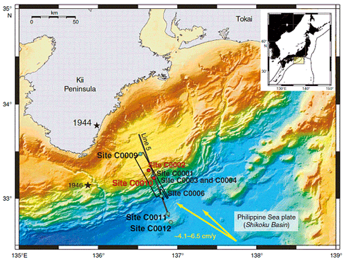
Figure 1: NanTroSEIZE study area and drilling Sites (Sites in red: Drill sites in Exp. 332)
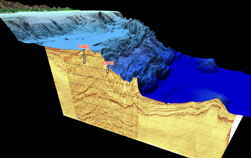
Figure 2: 3D Image of sea floor topography and subseafloor structure at NanTroSEIZE sites
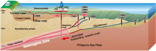
Figure 3: NanTroSEIZE Drilling Plan (Sites in red: Drill sites in Exp. 332)
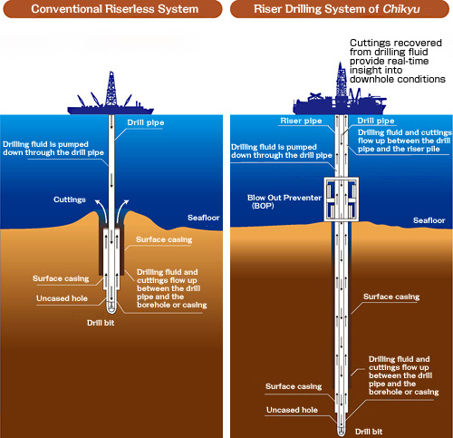
Figure 4: Riserless system (left) and Riser system (right)
Contacts:
- Japan Agency for Marine-Earth Science and Technology
(For Expedition 332) - Hiroyuki Kikuta, Group Leader
IODP Department
Center for Deep Earth Exploration (CDEX)
- (For IODP)
- Toshihiko Hoshino, Deputy Director, Planning Department
- (For publication)
-
Toru Nakamura, e-mail: press@jamstec.go.jp
Manager, Planning Department Press Office