Press Releases
Japan Agency for Marine-Earth Science and Technology
National Institute of Advanced Industrial Science and Technology
Atmosphere and Ocean Research Institute, The University of Tokyo
Graduate School of Frontier Sciences, The University of Tokyo
Japan Drilling Earth Science Consortium
Preliminary Report on Enshunada Sea Drilling by Chikyu from Long-Term, Continuous Earthquake Records
The Japan Agency for Marine-Earth Science and Technology(JAMSTEC)conducted a drilling expedition to determine the long-term earthquake history of the Enshunada Sea area on the eastern part of the Nankai Trough from January 5–8, 2020 (Figure 1). This work was performed as part of the Chikyu (Note 1) Shallow Core Program (SCORE, Note 2), which was jointly operated with the Japan Drilling Earth Science Consortium (J-DESC, Note 3). We are pleased to announce the preliminary findings following onboard analyses of drilled samples, conducted by JAMSTEC, the National Institute of Advanced Industrial Science and Technology, and the Atmosphere and Ocean Research Institute and Graduate School of Frontier Sciences of The University of Tokyo.
1.Overview
Historical earthquakes are known from the Enshunada Sea, which forms the eastern end of the Nankai Trough. Earthquakes have occurred in this area at intervals that differ from those in other areas across the trough, where an oceanic plate continues to subduct beneath a continental plate. It is generally thought that earthquakes occur when these plates slide quickly along the boundary. As it is believed that a topographic high between the two plates in the Enshunada Sea suppresses the occurrence of earthquakes, the intervals between earthquakes may be longer than in other Nankai Trough areas. The evidence for this should be recorded in local marine sediments; however, previously recovered samples have not provided a long enough time interval to verify these hypotheses.
On the expedition undertaken in this study, continuous sampling was conducted using a coring system on the research vessel Chikyu, and we were able to successfully collect sediment layers formed by earthquakes (i.e., turbidites, Note 4) at a depression on the seafloor of the Enshunada Sea, where we expected the most continuous geological records to have been preserved. We recovered more than 80 m of continuous sedimentary samples by drilling. In the upper 40-m layer, we found an interval that contained approximately 200 turbidites (Figure 2). Based on the sedimentation rates suggested in previous studies, the period recorded by these 40 m spanned 40,000–50,000 years. As approximately 200 turbidites were found, the average turbidite depositional interval was approximately 200 years. This is the first time that turbidite sequences, which are considered to form during earthquakes, have been collected for such a long period of time (40,000—50,000 years).
As records of land-based tsunami deposits are generally limited in age to tens of thousands of years ago due to changes in sea level, the long-term records we obtained are extremely valuable. We were able to obtain these records because of the Chikyu's hydraulic piston coring system (Note 5), which enabled the sampling of extensive sedimentary intervals with minimal disturbance. In the future, we plan to determine the geologic time period/s in which the turbidites formed and to examine their depositional intervals in greater detail. As these analyses will be based on continuous data from a sufficiently long period of time, we can expect to obtain new insights into the intervals between earthquakes in the Enshunada Sea.
- Note 1:
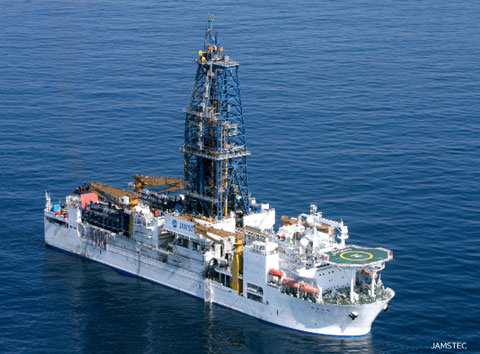
- Chikyu is a scientific drilling vessel owned and operated by JAMSTEC. The ship is equipped with riser drilling technology to allow drilling deep beneath the seafloor. The expeditions undertaken on this vessel contribute to our understanding of the mechanisms underlying the occurrence of large earthquakes and tsunamis, as well as to our knowledge of the seafloor and interstitial biosphere and global environmental change.
- Note 2:
- The Japan Drilling Earth Science Consortium (J-DESC) is a consortium established in 2003, led by universities and research institutes across Japan, with the aim of promoting drilling science and strengthening collaborations among organizations and researchers. The main activities of this group include examining scientific plans and research infrastructure related to drilling science, making proposals to related organizations, facilitating organic cooperation in scientific studies, educating scientists, supporting and cooperating with international projects, and conducting outreach activities.
- Note 3:
- The Chikyu Shallow Core Program (SCORE) employs the deep-sea scientific drilling vessel, Chikyu. This program is jointly managed by JAMSTEC and J-DESC. Scientific drilling (piston coring) on the surface of the seafloor can be completed within a short period of time, making effective use of the original round-trip routes of the Chikyu when entering sea areas. The Japan Drilling Earth Science Consortium calls for and reviews drilling proposals from its members and recommends some to JAMSTEC, which selects proposals and conducts the expeditions.
- Note 4:
- Turbidites are sedimentary deposits formed by the flow of sediment-laden water masses along submarines slopes by gravity. The flow occurs due to slope failure or the rolling up of seafloor sediments. As smaller particles sink relatively slowly, the lower parts of turbidites contain coarse sediments, while the upper parts are fine-grained.
- Note 5:
- Hydraulic piston coring is a method in which the tip of a sharp pipe is pushed into the sediment like a knife via the movement of a piston induced by water pressure in order to collect a core sample. The core can then be collected without rotating the drill bit (excavating blade), which greatly reduces disturbance.
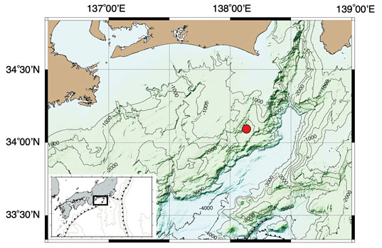
Figure 1. Enshunada Sea (black inset in lower left) and the drilling site (red dot). Drilling was performed at a water depth of 2,414 m.
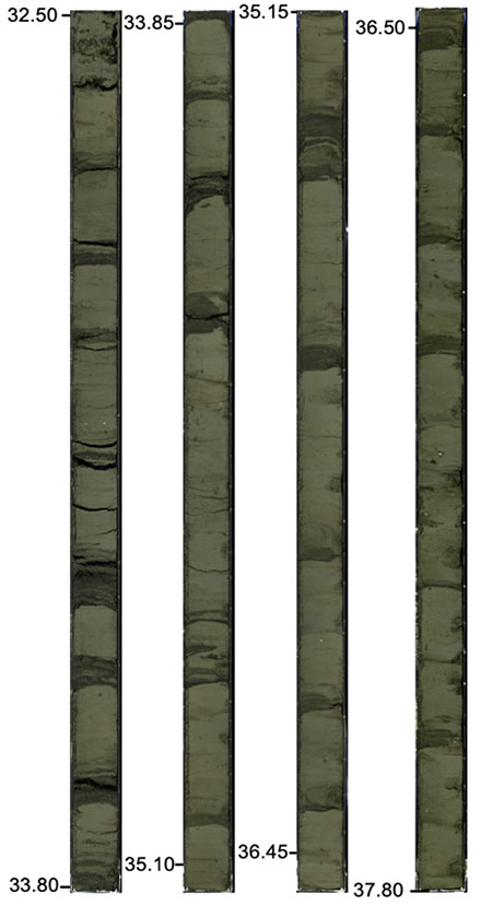
Figure 2. Photographs of sampled strata (i.e., layered sediments). Dark gray intervals correspond to the sandy parts of the turbidites. The numbers on the side indicate the depth (unit: m) from the seafloor.
Contacts
- (For this study)
- Toshiya Kanamatsu, Scientist, Research Institute for Marine Geodynamics , JAMSTEC
- (For press release)
- Public Relations Section, Marine Science and Technology Strategy Department , JAMSTEC