International Ocean Discovery Program (IODP) DV Chikyu to Set Sail for Expedition 405: Tracking Tsunamigenic Slip Across the Japan Trench (JTRACK)
Japan Agency for Marine-Earth Science and Technology (JAMSTEC: YAMATO Hiroyuki, President), will conduct IODP Expedition 405 “Tracking Tsunamigenic Slip Across the Japan Trench (JTRACK)” with the Deep-Sea Scientific Drilling Vessel Chikyu※1 as part of the International Ocean Discovery Program (IODP)※2.
・Expected Period: Sep 6, 2024~Dec 20, 2024
・Area: The Japan Trench, Approx. 200 km off Miyagi(See Appendix Fig 1)
・Overview: See Appendix
Chikyu
Drilling Vessel provided by Japan for IODP scientific drilling
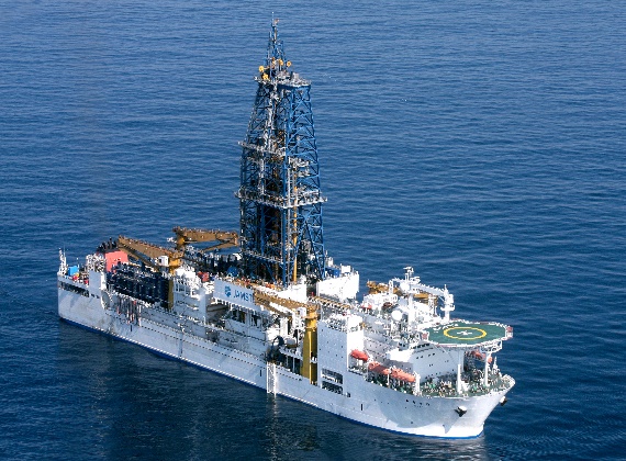
©JAMSTEC/IODP
International Ocean Discovery Program (IODP)
IODP is an international scientific research cooperative project started in October 2013. By drilling deep below the ocean floors using drilling vessels provided by Japan (JAMSTEC DV Chikyu), the United States (JOIDES Resolution), and Europe (Mission-Specific Platforms), IODP promotes research aimed at elucidating the global environmental change, the Earth’s internal structure and the biosphere within its crust. The current IODP is scheduled to end in September 2024.
Appendix
International Ocean Discovery Program (IODP) DV Chikyu to Set Sail for Expedition 405: Tracking Tsunamigenic Slip Across the Japan Trench (JTRACK)
1. Scientific background and objectives
During IODP Expedition 343 “Japan Trench Fast Drilling Project (JFAST)” in 2012, core samples were successfully collected from a part of the plate boundary fault that caused the 2011 Tohoku earthquake, and the results of the analysis revealed that the fault area contains a large amount of clay minerals (smectite), which is slippery and does not easily release the water it contains. In addition, the physical property data of the plate boundary fault was analyzed to investigate how the stress changed when the earthquake occurred, and it was found that the stress that had accumulated before the earthquake was almost completely released at the time of the earthquake. It is believed that the large-scale slip of the plate boundary fault caused by these factors triggered the enormous tsunami (Previously reported on October 8, 2013). The fault slip in this occasion extended all the way from the epicenter to the Japan trench.
Furthermore, measuring temperatures in the plate boundary fault made it possible to estimate the frictional heat generated by the fault slip at the time of the earthquake. The results of these measurements indicate that the fault slip caused by the earthquake was transmitted to shallow areas and that this frictional heat caused the water contained inside the clay in the fault to expand, causing a large slip. (Previously reported on December 6, 2013)
On the other hand, the following three issues still remain unresolved even based on these research results above.
- The current state of stress accumulation around the fault zone after more than 10 years after the earthquake.
- The structure of the fault that caused the earthquake, its physical characteristics, and the factors that control the slip behavior.
- The effects of fluids on the stress state around the fault zone.
This Expedition aims to clarify these questions by revisiting the JFAST study area, collecting core samples, Logging-While-Drilling (LWD)※3 and installing a Long-Term Borehole Measurement System (LTBMS).
Logging-While-Drilling (LWD)
A technology where a variety of physical properties data is measured near the drill bit at the bottom of the drill string and transmitted the data to the vessel in real time.
2. Overview of the expedition
IODP Expedition 405 (JTRACK) will be conducted in the Japan Trench, where the Tohoku earthquake occurred, with the Deep-Sea Scientific Drilling Vessel Chikyu. Revisiting the research area of IODP Expedition 343 (JFAST) in 2012, where the frictional heat generated by the earthquake was captured, JTRACK will attempt to elucidate the post-earthquake fault recovery process, the slip mechanism of shallow part of the plate boundary fault and the effect of the material properties of subduction zones on plate boundary faults. Drilling will be performed in the shallow part of the plate boundary where the large slip occurred (JTCT-01A) and on the subducting Pacific plate (JTCT-02A). Logging-While-Drilling and core sampling will be carried out at both sites. A Long-Term Borehole Measurement System (LTBMS) will be installed at site JTCT-01A to capture detailed depth profiles of sub-seafloor temperatures.
3. IODP Expedition 405 Research Team
Co-Chiefs (6 people)
KODAIRA Shuichi JAMSTEC, Japan
Christine Regalla Northern Arizona University, USA
Jamie Kirkpatrick University of Nevada, Reno, USA
UJIIE Kohtaro University of Tsukuba, Japan
Marianne Conin University of Lorraine, France
Patrick Fulton Cornell University, USA
In addition, a total of 56 science party members (from 10 countries) will participate, including 50 researchers (19 from Japan) selected from IODP participating countries.
4. Dedicated website
A dedicated website of the expedition has been launched. This website provides an overview of the expedition, introduces the participating researchers and will be updated with the progress of the expedition.
https://www.jamstec.go.jp/chikyu/j/exp405/
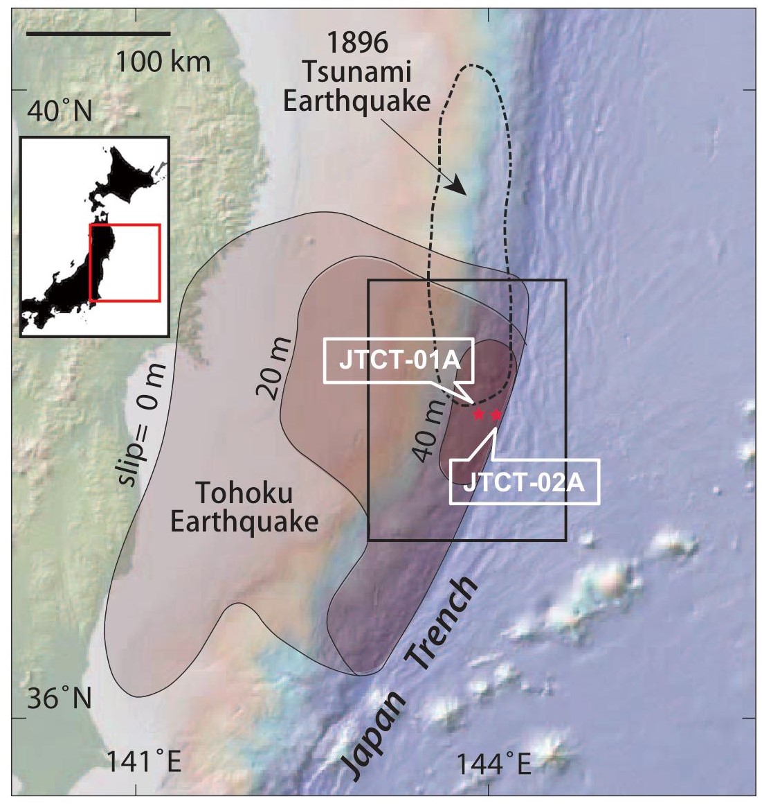
Fig 1. Survey Area(Chester et al.2013): Drilling will be carried out at two sites, Sites JTCT-01A and JTCT-02A.
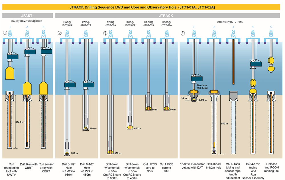
Fig 2. Drilling plan
- Reinstalling the Long-Term Borehole Measurement System (LTBMS)
The LTBMS will be reinstalled using the tubing left at Site C0019 drilled by JFAST. - Logging-While-Drilling (LWD)
At two sites, JTCT-01A and JTCT-02A, geological data of the borehole wall will be obtained to the target depth while drilling below the seafloor using Logging-While-Drilling (LWD) tools. - Core sampling
At two sites, JTCT-01A and JTCT-02A, geological samples will be collected in cylindrical form from the seafloor to the target depth (JTCT-01A: 950 m, JTCT-02A: 450 m). - Installation of a new LTBMS
At Site JTCT-01A,
- A wellhead is installed on the seafloor monitored by an underwater camera.
- Drilling is carried out to the target depth.
- The LTBMS is attached to the drill string and reconnected from the wellhead into the borehole to install the new sensors.
- Finally, disconnect the LTBMS from the drill string to complete the installation.
For IODP and the expedition
General Affairs Group, Planning and Coordination Department, Institute for Marine-Earth Exploration and Engineering (MarE3)
For press release