[follow-up report] A rare combination of a positive Indian Ocean Dipole and a La Niña Modoki may bring an abnormal season
This column is a follow-up to a researcher's column published on March 25, 2024.
Last year’s super El Niño event peaked at the end of last year and has gradually weakened. It's now almost over, and there are weak signs of a La Niña event. Meanwhile, tropical Indian Ocean is experiencing above normal temperature, featuring a positive phase of the Indian Ocean Basin Mode (Note 1). However, warmer temperatures in the west compared to east suggest the development of a positive phase of the Indian Ocean Dipole.
Our prediction system “SINTEX-F” predicts that a weak La Niña-Modoki, rather than a canonical La Niña event as predicted by some other models, will appear in the boreal summer and persist into the boreal winter (Fig. 1). It also predicts a positive Indian Ocean Dipole, similar to last year. This is a significant change from the model's prediction on March 1, 2024, which indicated a negative Indian Ocean Dipole.
Typical Indian Ocean Dipole events reach their peak in the boreal autumn, but this Indian Ocean Dipole event is predicted to reach its peak in the summer, which may be an unusual case. Positive Indian Ocean Dipole events usually coincide with El Niño events, and it's rare for a positive Indian Ocean Dipole event to coincide with a La Niña event. Something similar happened in 2007. That summer, Japan experienced a record-breaking heat wave. Global warming has further advanced since then. It is advisable to keep an eye on the progress of the Indian Ocean Dipole and La Niña developments.
For more on La Niña Modoki and Indian Ocean Dipole vents, check out the Researcher's Column from March 25.
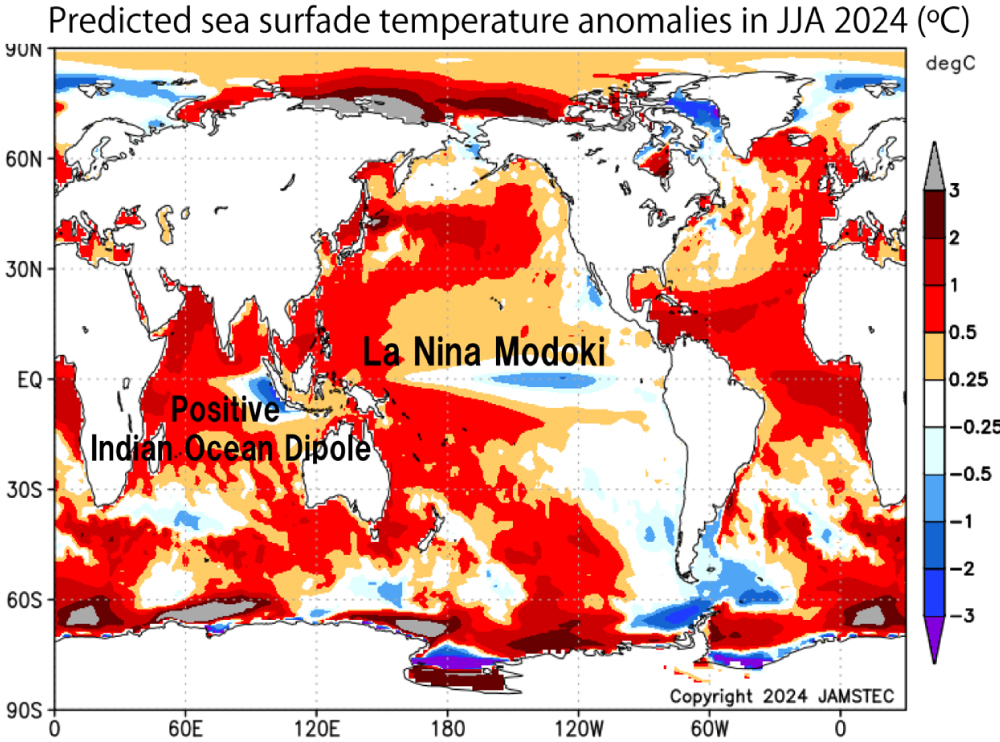
Figure 1: Sea surface temperatures (SST) (ºC) averaged over the three months from June to August 2024 as predicted by the SINTEX-F seasonal prediction system as of May 1, 2024, illustrating the difference from the normal (1991–2020 average) for the same months. Warm (cold) colors indicate higher (lower) water temperatures than normal. The lower-than-normal water temperatures in the central tropical Pacific and higher-than-normal temperatures in the eastern and western parts of the region are indicative of a La Niña Modoki event. It can also be seen that a positive Indian Ocean Dipole event will occur, as SSTs are above normal in the western part of the tropical Indian Ocean and below normal in the eastern part. The latest information can be found on the SINTEX-F website and APL Virtualearth.
Note 1: It means that the water temperature in the whole tropical Indian Ocean increases more than normal, which tends to occur after an El Niño event. If the water temperature falls below normal, it is called a negative event.