What's TRITON
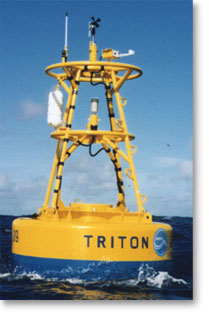
What is TRITON buoy ?- The TRITON (Triangle Trans-Ocean buoy Network) is a series of buoys for measuring surface meteorology and upper ocean.
- The buoys will be deployed by JAMSTEC in collaboration with many countries in and around the Pacific Ocean as part of international climate research programs.
- The purpose is for scientific research on warm water in the equatorial ocean affecting world climate change.
 |
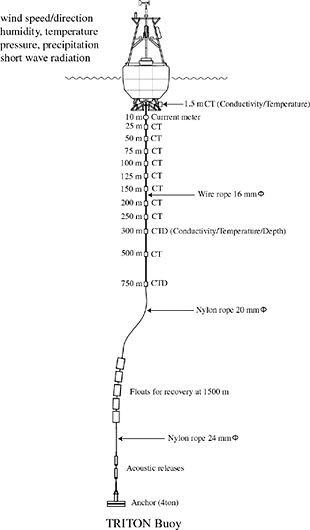
What do the buoys measure ?
The buoy data are utilized for daily weather forecasts in the world.
|
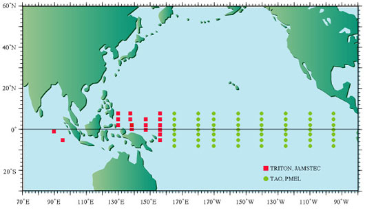
- JAMSTEC will deploy 18 buoys in the western tropical Pacific and eastern Indian Ocean.
- In the central and eastern Pacific , USA has deployed Tropical Atmosphere Ocean (TAO) buoys. The TRITON buoys have been deployed at the following locations.
| Nominal | Exact Locations | Deployed date |
|---|---|---|
8N,156E |
8° - 01.30'N, 155° - 56.11'E |
10 Feb. 2005 |
5N,156E |
4° - 58.49'N, 156° - 02.18'E |
8 Feb. 2005 |
2N,156E |
2° - 02.23'N, 156° - 01.21'E |
5 Feb. 2005 |
0N,156E |
0° - 00.73'N, 156° - 02.98'E |
2 Feb. 2005 |
2S,156E |
2° - 01.00'S, 155° - 57.59'E |
31 Jan. 2005 |
5S,156E |
5° - 01.93'S, 156° - 01.50'E |
29 Jan. 2005 |
5N,147E |
4° - 57.87'N, 147° - 01.69'E |
21 Jan. 2005 |
2N,147E |
1° - 59.54'N, 147° - 01.09'E |
24 Jan. 2005 |
0N,147E |
0° - 03.65'N, 147° - 00.70'E |
25 Jan. 2005 |
8N,137E |
7° - 38.95'N, 136° - 41.92'E |
13 Jun. 2004 |
5N,137E |
4° - 51.60'N, 137° - 15.62'E |
21 Jun. 2004 |
2N,138E |
2° - 04.02'N, 138° - 03.74'E |
16 Jun. 2004 |
0N,138E |
0° - 02.03'N, 137° - 52.90'E |
18 Jun. 2004 |
8N,130E |
7° -58.83'N, 130° - 02.10'E |
24 Jul. 2004 |
5N,130E |
under a pause |
- |
2N,130E |
2° - 01.69'N, 130° - 11.39'E |
25 Jul.-2004 |
5S,95E |
5° - 02.21'S, 94° - 58.58'E |
9 Jul. 2004 |
1.5S,90E |
1° - 36.17'S, 90° - 04.49'E |
12 Jul. 2004 |
The buoys are securely anchored
The buoy data help fishing activities
Advise to fishermen
|
 |