Long-Term Global Change Projection
Shaping the globe with our descendants far into the future
Long-term global environmental projection using an integrated earth system model
The continuing anthropogenic emission of CO2 will worsen global warming. Recent studies have warned that global warming and sea-level increases will continue for more than a century, even if the CO2 concentration can be stabilized at a constant level during this century. Furthermore, achieving the stabilization of CO2 may not be possible if we focus only on anthropogenic emissions because global warming affects various processes of the land (forests and soils) and ocean (nutrient and plankton) ecosystems and the absorption of atmospheric CO2 by the sea surface. We will project global warming using an integrated earth system model and project long-term changes in the global environment under various CO2 stabilization scenarios. We will also estimate the allowable CO2 discharges under CO2 stabilization scenarios based on the results of the global warming projection. Uncertainty estimation of the global warming projection and reduction of the uncertainty will be achieved via additional numerical experiments that incorporate statistical approaches. In addition, natural disaster impact assessment will be conducted based on the global warming projection.
Projection of long-term global change
The improvement of the integrated earth system model that was developed during the MEXT project Kyosei 2 is planned to allow for global warming projections up to the year 2300. The model consists of biogeochemistry components with coupled atmosphere-ocean-land carbon-cycle feedback and atmospheric chemistry -aerosol interaction at resolutions of 200 km for the atmosphere and 100 km for the ocean. Our focus is on the introduction of a dynamic vegetation model, the advancement of the carbon cycle model and aerosol transport model, and the improvement of physical processes such as an ice sheet. Using global warming experimental data, we will estimate the temperature rise, sea level rise, and allowable CO2 concentration under various CO2 stabilization scenarios.
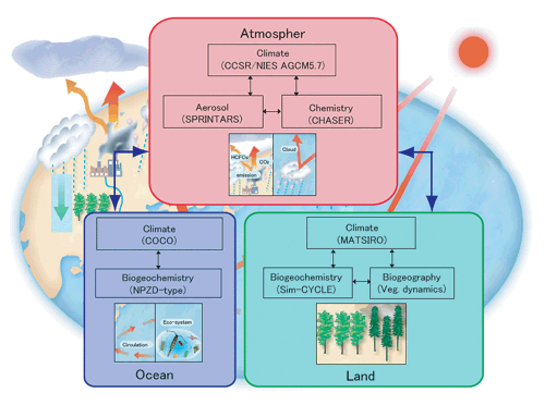
Fig1. Schematic representation of the integrated earth system model.
Reduction in cloud uncertainty using a global cloud-resolving model
To reduce the large uncertainty regarding cloud behavior in current climate models, we use a newly developed, innovative, high-resolution global atmospheric model with global cloud-resolving capabilities. With a horizontal mesh size of a few kilometers and direct resolving of deep clouds in the tropics, the model simultaneously calculates multi-scale disturbances from cloud- to planetary-scale circulations. This global cloud-resolving model is expected to provide a greater understanding of physical cloud-feedback mechanisms and contribute to more reliable projections of monsoon circulations and tropical cyclones.
Development of a global vegetation model
Climate conditions strongly affect the terrestrial ecosystem. The terrestrial ecosystem also affects the climate, particularly through changes in evapotranspiration, carbon cycling, and albedo. Thus, for the reliable projection of global climate changes, integrated terrestrial ecosystem models that include biogeochemical processes and vegetation dynamics are required. To fulfill this need, this research is developing a global vegetation model that simulates changes in ecosystem functions (e.g., carbon and water fluxes), as well as ecosystem structures (e.g., distribution and composition). This model links several modules that have different computational time steps. Some of the modules are functions of environmental factors, allowing the model to simulate ecosystem responses to environmental changes.
Uncertainty estimation for long-term climate change projection using a hierarchy of models
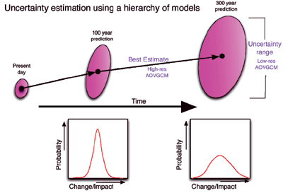
Fig2. Concept of the filtering techniques that can be used to sort out the experimental results.
Evaluation of how natural disasters associated with climate change will affect the stability of major cereal crop production
Major production areas for cereals, especially maize and soybean, are located in China, USA, and Brazil. There is a risk that natural disasters associated with climate change could occur simultaneously in these areas, resulting in massive damage to world cereal production. This research aims to evaluate the probability of such simultaneous disasters and the resulting instability of the world cereal supply.
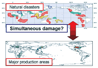
Fig3. Upper: Spatial distribution of weather anomaly associated with El Nino or La Nina event. Lower: Spatial distribution of land density for corn and soybean cultivation.
Long-term global assessment of coastal hazard risks in relation to sea-level rise and global warming
The target of this research is to predict inundation and flood risks caused by sea-level rise and storm surges induced by tropical cyclones that are enhanced by global warming. The assessment will cover all coastal areas of the world until 2300 and will be based on long-term simulations of sea-level rise and global warming by the earth simulator. Of particular focus are Asian mega-delta areas because of the compound risks of inundation and flooding, as well as land subsidence and saltwater intrusion. Coastal risks will be evaluated by considering the area, population, and properties (land uses) of the inundated and/or flooded areas. The prediction of these risks will help in the development of appropriate strategies and risk-management measures against sea-level rise and global warming.