Press Releases
January 17, 2013
JAMSTEC
Deep-Sea Drilling Vessel Chikyu
Integrated Ocean Drilling Program (IODP) Expedition 338:
Nankai Trough Seismogenic Zone Experiment (NanTroSEIZE)
Stage 3
From 3 October 2012, the Japan Agency for Marine-Earth Science and Technology (JAMSTEC: Asahiko Taira, President) deep-sea drilling vessel Chikyu has been deployed on the Integrated Ocean Drilling Program (*1 IODP) Expedition 338: The Nankai Trough Seismogenic Zone Experiment (NanTroSEIZE) Stage 3. This fiscal year’s final expedition has finished and the DV Chikyu is scheduled to dock at Shimizu Harbor, Shizuoka Prefecture on 13 January 2013.
1. Investigation Overview
The NanTroSEIZE expedition plans for FY2012 included drilling from 860 to 3600 m below the seafloor at IODP Site C0002, located 80 km off the Kii Peninsula. After drilling reached 2000 m below the seafloor, sudden changes in sea and weather conditions resulted in damage to vital drilling equipment (Previously reported on 22 November 2012). This necessitated in switching to contingency drilling plans (drill sites shown in Fig. 1), and drilling scheduled for FY2014 at other NanTroSEIZE locations was conducted, including collection of core samples and logging-while-drilling (LWD) (*2).
The objectives of the contingency drilling plans were obtaining information on the history of mega-splay fault activity, the physical properties of the geological strata of the oceanic plate prior to subduction and the internal structure of the accretionary prism after forming from material accreted from the subducting oceanic plate. The data collected will be analyzed and integrated with previously collected data from earlier NanTroSEIZE IODP expeditions. The goals of NanTroSEIZE remain clarifying the structure and formation processes for oceanic plate subduction zones and changes in plate boundary faults with the objective of elucidating the mechanisms for occurrences of mega-earthquakes and tsunamis.
Drilling beyond 2000 m below the seafloor is scheduled to resume during the next fiscal year.
2. Future DV Chikyu Operating Schedule.
- ·January 13:
- Dock at Shimizu Harbor, Shizuoka
Prefecture (Okitsu Wharf) - ·January 13 to Late March:
- Contract Operations (Offshore of Atsumi Peninsula)
*1 The Integrated Ocean Drilling Program (IODP)
IODP is an international marine research-drilling program dedicated to advancing scientific understanding of the Earth by monitoring and sampling subseafloor environments. Through multiple platforms, scientists explore IODP's principal themes: the deep biosphere, environmental change, and solid Earth cycles. IODP has been in operation since October 2003, funded jointly by the Japan Ministry of Education, Culture, Sports, Science and Technology and by the U.S. National Science Foundation. The 18-member European Consortium of Ocean Research Drilling (ECORD), the People's Republic of China, the Republic of Korea, India, Australia and New Zealand (ANZIC), Federative Republic of Brazil provide additional support.
*2: Logging-while-drilling (LWD)
LWD is a technique to measure geophysical properties at a site while drilling, through physical measurement sensors attached near the drill bit. With this technique, core sampling is not possible; however, continuous in-situ measurement of downhole conditions allows for characterizing the geology at the site in a relatively short time. In addition to valuable science data, the LWD can provide information to ensure the safety of the following coring operations and avoid risk. As such, LWD is a very effective tool to drill in complex geology, like the Nankai Trough.
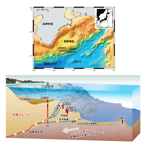
Figure 1 Drilling Sites
Investigation of sediments above seismogenic zone
Site C0002
Location: 33°18.5'N 136°38.2'E,
Ocean Depth: Approximately 1940 m
Drilling Depth: Approximately 1120 m
Operations: Collection of core samples
Investigation of oceanic plate prior to subduction beneath continental plate
Site C0012
Location: 32°44.9'N 136°55.0'E
Ocean Depth: Approximately 3510 m
Drilling Depth: Approximately 700 m
Operations: LWD
Investigation of geologic strata records of history of mega-splay fault activity
Site C0018
Location: 33°09.4'N 136°40.9'E
Ocean Depth: Approximately 3090 m
Drilling Depth: Approximately 350 m
Operations: LWD
Site C0021
Location: 33°10.0'N 136°39.8'E
Ocean Depth: Approximately 2940 m
Drilling Depth: Approximately 290 m
Operations: LWD and collection of core samples
Site C0022
Location: 33°13.1'N 136°43.5'E
Ocean Depth: Approximately 2680 m
Drilling Depth: Approximately 420 m
Operations: Logging while drilling and collection of core samples
* Core Samples Total: 832.4 m LWD total: 3780.5 m. Analysis of these samples and records will be conducted.
Contacts:
- Japan Agency for Marine-Earth Science and Technology (JAMSTEC)
(For the study) -
Yasuo Yamada, Manager
Planning and Coordination Department
Center for Deep Earth Exploration (CDEX)
- (For publication)
-
Kazushige Kikuchi, Director
Planning Department Press Office
Email: press@jamstec.go.jp