Press Releases
August 11, 2014
JAMSTEC
Satellite-based Observations May Be Underestimating
Tropospheric NO2 Vertical Column Density (TropoNO2VCD)
~ Light Scattering Effects of Co-existing PM2.5 Aerosols ~
1.Overview
International Research Team led by Dr. Yugo Kanaya, Deputy Director, Department of Environmental Geochemical Cycle Research, Japan Agency for Marine-Earth Science and Technology (JAMSTEC: Asahiko Taira, President) found that satellite observation data of Nitrogen Dioxide (NO2), which is one of air pollutants, had low biases up to 30%~50%. Based on the examination of satellite data using ground-based MAX-DOAS*1 network observations in Japan, China, Korea, and Russia, it is possibly related to the shielding effect caused by co-existing aerosols such as PM2.5*2, which obscure detection of NO2 near the earth's surface by scattering sunlight serving as probe light for satellite observation.
This result means that it is necessary to revise upwards the emission rates of nitrogen oxides that have been estimated based on satellite data and also environmental impacts of human activity can be even greater than expected. In addition, the observational results suggest for the first time that it is necessary to consider the light-scattering effect caused by aerosol particles such as PM2.5 in accurately retrieving the amount of NO2 from satellite observation.
We will continue NO2 observations with the ground-based network and also extend the scope of analysis including other molecules, seeking similar impacts of aerosols.
This work was supported by the Japan EOS Promotion Program (JEPP) and KAKENHI Grant numbers 25220101 and 26550022 of the Ministry of Education, Culture, Sports, Science, and Technology in Japan, JSPS and RFBR (research project No. 12-05-92108_Jap_a and 11-05-01175-a) under the Japan-Russia Research Cooperative Program, and the Environmental Research and Technology Development Fund (S-7) of the Ministry of the Environment, Japan.
These research results have been published in an Interactive Open Access Journal of the European Geosciences Union, Atmospheric Chemistry and Physics on August 11.
Title: Long-term MAX-DOAS network observations of NO2 in Russia and Asia (MADRAS) during 2007-2012: instrumentation, elucidation of climatology, and comparisons with OMI satellite observations and global model simulations
Authors: Yugo Kanaya1, H. Irie1,a, H. Takashima1,b, H. Iwabuchi1,c, H. Akimoto1,d, K. Sudo2, M. Gu3, J. Chong3, Y. J. Kim3, H. Lee3,e, A. Li4, F. Si4, J. Xu4, P.-H. Xie4, W.-Q. Liu4, A. Dzhola5, O. Postylyakov5, V. Ivanov5, E. Grechko5, S. Terpugova6, and M. Panchenko6
- 1.
- JAMSTEC
- 2.
- Nagoya University
- 3.
- Gwangju Institute of Science and Technology (GIST), Korea
- 4.
- Anhui Institute of Optics and Fine Mechanics, Chinese Academy of Sciences, China
- 5.
- A. M. Obukhov Institute of Atmospheric Physics, Russian Academy of Sciences, Russia
- 6.
- V. E. Zuev Institute of Atmospheric Optics, Siberian Branch of the Russian Academy of Sciences, Russia
Now at:
a. Chiba University b. Fukuoka University c. Tohoku University
d. Asia Center for Air Pollution Research e. Pukyong National University, Korea
*1 MAX-DOAS (Multi-Axis Differential Optical Absorption Spectroscopy) is a remote sensing measurement of atmospheric gases and aerosols in the air. It is based on a technique measuring UV/Visible hyperspectra of scattered sunlight at several low elevation angles.
*2 An aerosol is a colloidal system of solid or liquid particles suspended in the atmosphere. PM2.5 particles are the fine fraction of those particles, with diameters of 2.5 micrometers or smaller. They significantly interact with the ultraviolet and visible solar radiation.

Figure 1: Change in tropospheric NO2 vertical column density (TropoNO2VCD) in Eastern Asia based on satellite observation. It has tripled over China in the last 15 years. However, the absolute value has remained highly uncertain.
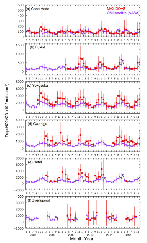
Figure 2: Time series of monthly averages of MAX-DOAS (shown in red) and satellite observations of TropoNO2VCD (shown in purple) at six locations. The satellite observations tend to show lower values.
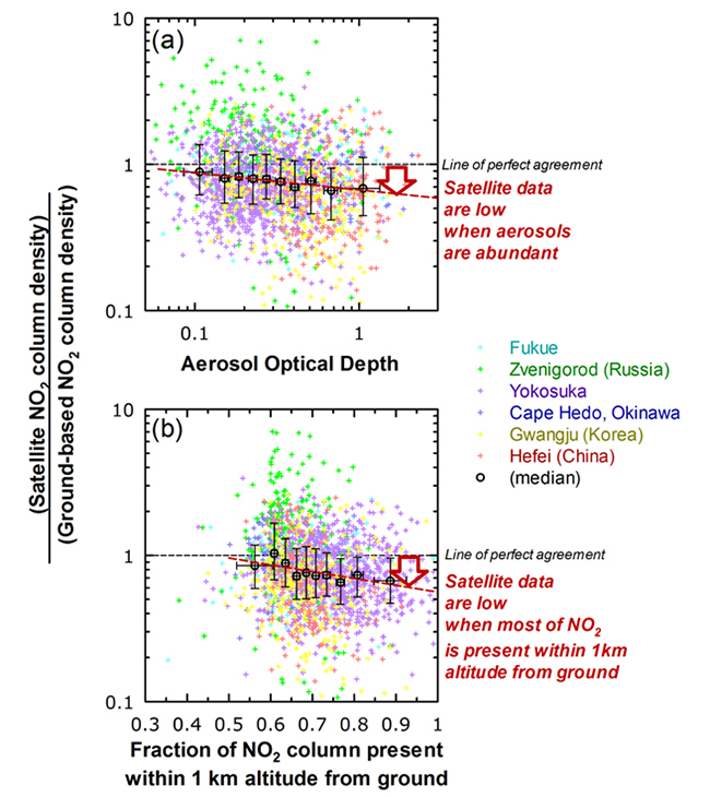
Figure 3: It was found that OMI satellite data have low biases compared to those from ground observations (shown with red allow) when aerosol optical depth is larger (the figure a) and when NO2 is abundantly present near the Earth’s surface (the figure b).
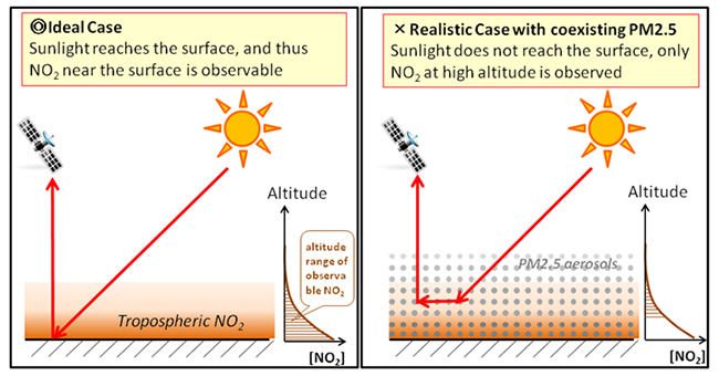
Figure 4: Conceptual diagram of shielding effect caused by co-existing PM2.5 aerosols. Co-existing PM2.5 aerosols prevent sunlight from reaching the earth’s surface. As a result, satellite observation fails to detect NO2 near the Earth’s surface.
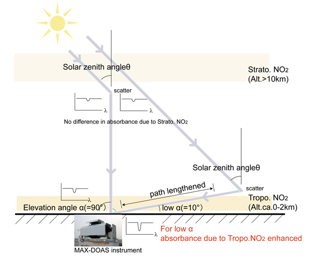
Reference 1: Principle of ground-based remote sensing based on the MAX-DOAS technique.
Reference 2:
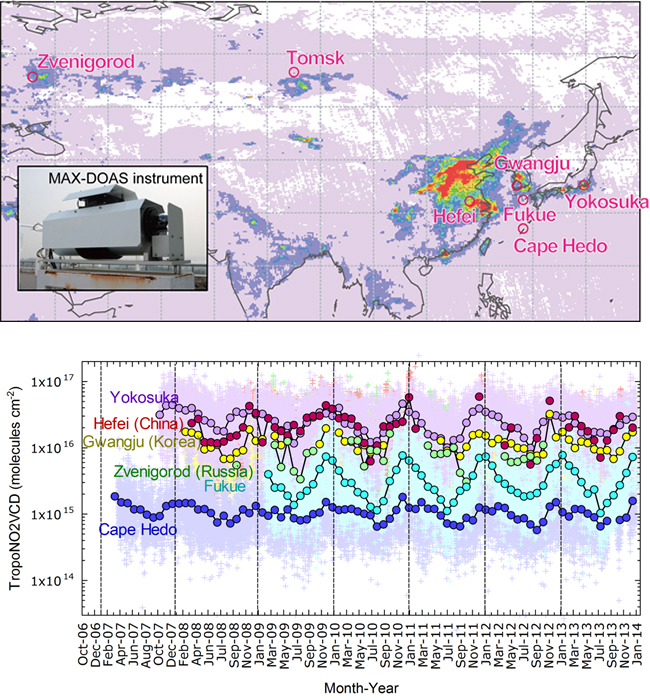
(The diagram above) Locations of MAX-DOAS network observations
(The diagram elow) Time series of all individual observations of TropoNO2VCD
Contacts:
- (For this study)
-
Yugo Kanaya, Deputy Director,
Department of Environmental Geochemical Cycle Research - (For press release)
-
Kazushige Kikuchi
Manager, Press Division, Public Relations Department