Press Releases
October 31, 2015
JAMSTEC
Observation of Deep-sea Environmental Changes
after the 2011 Off the Pacific Coast of Tohoku Earthquake
~Long-term monitoring data at deep-sea stations provide new data~
Dr. Kazumasa Oguri, Senior Research Scientist, Project Team for Analyses of Changes in East Japan Marine Ecosystems and his colleagues at the Japan Agency for Marine-Earth Science and Technology (JAMSTEC: Asahiko Taira, President) carried out long-term monitoring of the seafloor environment off Otsuchi Bay, northeastern Japan to investigate environmental changes of the deep-sea floor after the 2011 off the Pacific coast of Tohoku Earthquake. Two self-powered deep-sea stations were deployed on an upper continental slope site (around 300m water depth) and on bathyal (998m) site. The respective monitoring periods were from March 13th 2013 to September 12th 2013 (upper continental slope) and from August 12th 2012 to October 12th 2013 (bathyal).
These long-term monitoring provided high-resolution environmental data in one hour interval and their time-series data illustrated seasonal changes in bottom water characteristics, which had not been available before. In particular, seafloor photographs and videos clearly recorded the disturbance and their subsequent recovery of benthic habitats after the largest aftershock during the monitoring period, which hit near the Japan Trench on December 7th, 2012, measuring at magnitude 7.3.
These data will contribute to long-term forecast models of oceanic environmental variability and also for planning of fishery activities. The research group will continue these observations to introduce data telemetry system using with an underwater winch technology for semi-real time monitoring.
This project was carried out as a part of Tohoku Ecosystem-Associated Marine Sciences funded by Ministry of Education, Culture, Sports, Science and Technology.
These study results were posted on the online English version of Journal of Oceanography issued by the Oceanographic Society of Japan on October 31th, 2015 (JST).
Title: Long-term monitoring of bottom environments of the continental slope off Otsuchi Bay, northeastern Japan
Authors: Kazumasa Oguri1, Yasuo Furushima1, Takashi Toyofuku1, Takafumi Kasaya1, Masahide Wakita1, Shuichi Watanabe1, Katsunori Fujikura1, Hiroshi Kitazato1
Affiliation: 1Project Team for Analyses of Changes in East Japan Marine Ecosystem, JAMSTEC
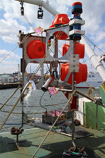
Figure 1: A deep-sea station used for the monitoring. The installed instruments are (1) ARGOS satellite transmitter, (2) RDCP 600, acoustic doppler current profiler, CTDDO-turbidity sensors with battery, (3) LED lights, (4) ROV homer, (5) glass spheres, (6) acoustic release transponder, (7) HDTV camera in a stainless pressure cylinder, and (8) oil-filled Lithium-ion battery for the camera and the lights.
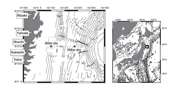
Figure 2: Two seafloor deployment sites off Otsuchi Bay, Sanriku region.
One is at 300m in initial water depth on the continental shelf (upper slope site), and the other at 998m depth on the slope (bathyal site). The distances from Otsuchi Bay are 21km and 45km, respectively.
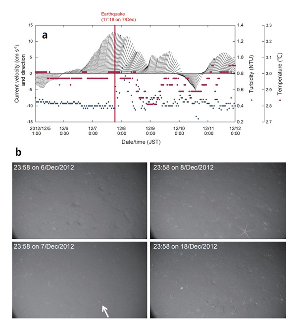
Figure 3: a) Horizontal current intensity, direction, turbidity and temperature at the bathyal site around the time of the earthquake (aftershock). Immediately after the earthquake, the degree of turbidity increased but it ceased within 24 hours. Temperature changes were not observed, and the flow direction and velocity had already showed changes prior to the earthquake.
b) Photographs of the seafloor. On December 6th 2012 before the aftershock, the turbidity in the water was low, and some burrows and ophiuroids were observed on the sediment surface. On December 7th, just after the earthquake, the intense turbidity was also observed from the photograph. Ophiuroids were buried in the sediment (shown by the arrow). On December 8th, turbidity was decreased and ophiuroids returned to the sediment surface but the burrows seen before earthquake were still filled with sediment. By December 18th, the seafloor recovered to the state before the earthquake.
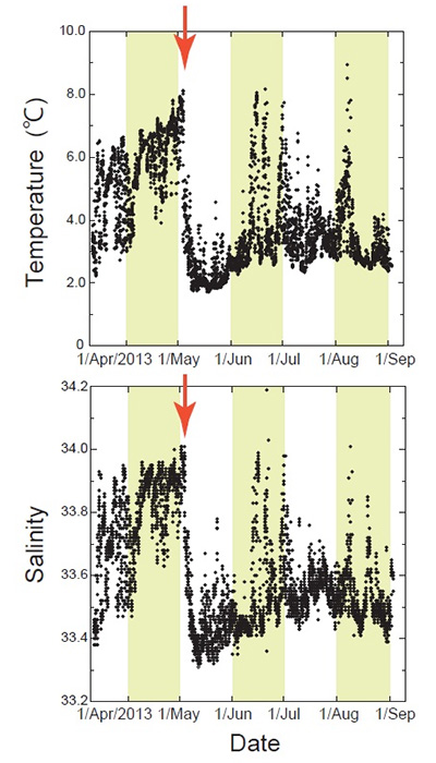
Figure 4: Temperature and salinity observed at the upper slope site (300m water depth).
The red arrows show intrusion of Oyashio water mass with lower temperature and salinity flowed south between the beginning and middle of May 2013.
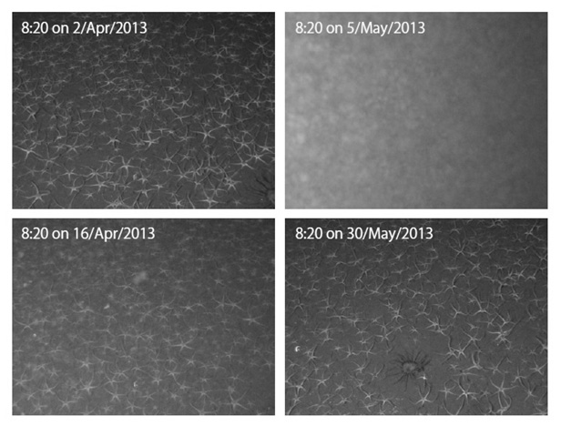
Figure 5: Seafloor photographs taken by the camera at the upper slope site. In spring, phytoplankton bloom in the surface layer of the ocean produce dense marine snow. A large amount of marine snow-falls were observed correlated with the blooming.
Contacts:
- (For this study)
- Kazumasa Oguri, Senior Research Scientists, Project Team for Analyses of Changes in East Japan Marine Ecosystems
- (For press release)
- Hiroyasu Matsui, Manager, Press Division, Public Relations Department