Press Releases
July 22, 2016
JAMSTEC
Siberian Larch Forests Can Persist
Despite Permafrost Melting under Forecasted Warming Trends
- A new model presents more accurate prediction of global climate changes -
Overview
The research team led by Hisashi Sato at Department of Environmental Geochemical Cycle Research, the Japan Agency for Marin-Earth Science and Technology (JAMSTEC: Asahiko Taira, President) examined endurance of larch forests ecosystems on permafrost*1 areas in eastern Siberia under forecasted warming trends. The team developed an integrated simulation model by combining a dynamic vegetation model (SEIB-DGVM) and a land physics model (NOAH-LSM). Simulations with the model demonstrated that plant productivity of the larch forests in eastern Siberia is likely to increase due to global warming effects despite rapid disappearance of near-surface permafrost for most part of the larch forests.
The area of larch forests in eastern Siberia is about ten times larger than the Japan's terrestrial area. The endurance of Siberian larch forests is considered to be dependent on near-surface permafrost as it helps retain soil water in near-surface soil layers by inhibiting its percolation to deeper soil layers. Existing land surface models have indicated a trend of surface permafrost decay due to rapid global warming around high latitudinal areas; however, its influences on the persistence of Siberian larch forest had been rarely examined.
Simulations with the model presented, however, that the flow of soil water from land surface to deeper layer would be limited to only several ten millimeters per year. Furthermore, the entire area of eastern Siberia will be moist with increase in annual precipitation by 100-300mm. As a result, it is more likely that plant productivity, biomass and leaf area index will increase in the entire larch forest.
The research team is further working on improvement of simulation accuracy by incorporating various factors such as plant stress caused by heat and excessive moisture, growth limitation due to nitrogen availability in soil, and impacts of topographic conditions on soil moisture and radiation availability. It is expected to lead to more sophisticated climate prediction at a local level and also on a global scale.
This study project was supported by JSPS KAKENHI Grant Numbers 25281003 and the Arctic Challenge for Sustainability (ArCS) project.
The above results were published in Ecology and Evolution on July 22, 2016 (JST).
Title: Endurance of larch forest ecosystems in eastern Siberia under warming trends
Authors: Hisashi Sato1, Hideki Kobayashi1, Go Iwahana2, Takeshi Ohta3
Affiliations: 1 Department of Environmental Geochemical Cycle Research, JAMSTEC
2 International Arctic Research Center, University of Alaska Fairbanks
3 Graduate School of Bioagricultural Sciences, Nagoya University
*1 Permafrost
Permafrost is defined as soil that has been frozen for two or more consecutive years. It is nearly imperviousness to soil water. In most part of Siberian larch forests, permafrost extends as deep as several hundred meters. An active layer, which thaws only in summer, can exist immediately above the permafrost layer.
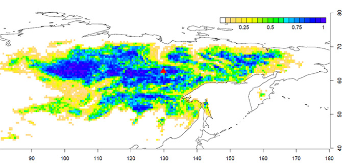
Figure 1. Geographical distribution of larch forests in eastern Siberia
Color scales indicate the fraction of larch forest in each 0.5° grid square, which is taken from the Global Land Cover 2000 data sets (IES Global Environment Monitoring Unit, 2003). The red triangle shows the location of the study site. The vertical and horizontal axes, show latitude and longitude, respectively.
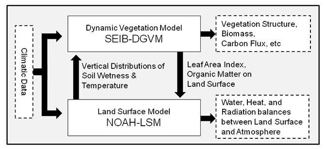
Figure 2. A schematic diagram of an integrated model developed for this study
This model is composed of the dynamic vegetation model SEIB-DGVM (Spatially-Explicit Individual-Based DGVM) developed at the initiative of JAMSTEC, and the NOAH land-surface-model developed by National Centers for Environmental Prediction (NCEP) at National Weather Service and other research institutes in the U.S.
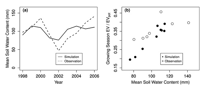
Figure 3. An example of model validation
Comparisons of simulations and observations in inter-annual variations of (a) mean soil-water-content and (b) relationships between mean soil-water-content and evapotranspiration efficiency (actual evapotranspiration rate divided by its potential maximum). All values are 3-month averages in June, July and August, which correspond to the larch growing season at the study site.
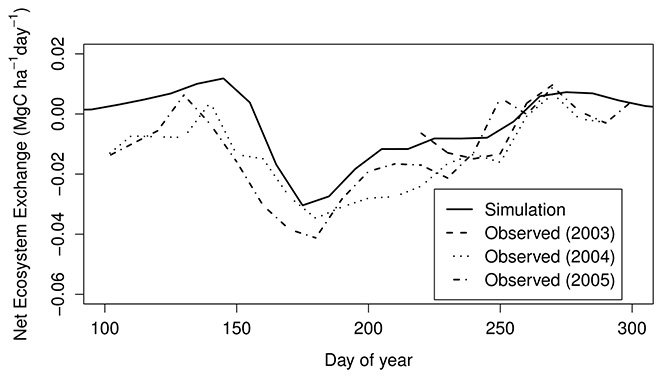
Figure 4. An example of model validation
It shows ten days running means of net-ecosystem-exchange (NEE), which is the net-carbon-balance of an ecosystem. A positive NEE represents that the ecosystem functions as net source of carbon (i.e. carbon emission exceeds carbon uptake). The model reproduces a conspicuous characteristic of this ecosystem; CO2 absorption begin at mid-May (around the 135th days from January 1) when larch foliation occurs, then gradually decreases from early July (around the 185th day from January 1), when drought stress intensifies.
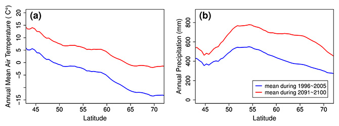
Figure 5. Latitudinal gradients of (a) annual mean air temperatures and (b) annual precipitation
The annual means from 1996 to 2005 are based on observation, while those from 2091 to 2100 are predictions from an earth-system-model, MIROC-ESM, forced with the RCP 8.5 scenerio (rising radiation forcing pathway leading to 8.5 W/m²) of the Intergovernmental Panel on Climate Change (IPCC). During the 21st century, the MIROC-ESM forecasts increase in annual mean air temperature by 8-12°C and annual precipitation by 100-300mm in the entire eastern Siberia.
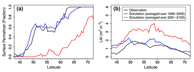
Figure 6. Latitudinal gradients of (a) fraction of area where near-surface permafrost exists and (b) leaf area index (LAI), which is one sided green leaf area per unit ground area. Comparisons of observation and simulation from 1996 to 2005 show that the model reasonably reproduces geographical distribution of surface permafrost and LAI under the current climatic condition. The model simulates a diminishing trend of near-surface permafrost and an increasing trend of LAI during the 21st century.
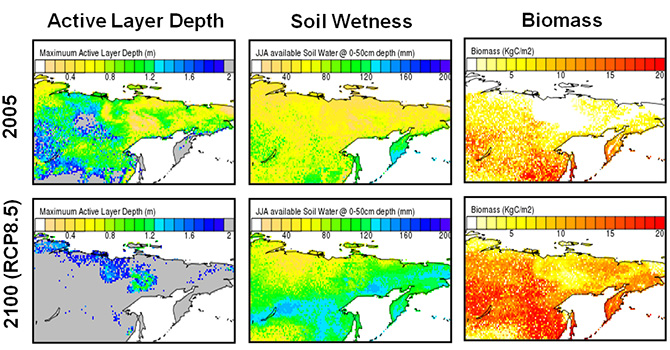
Figure 7. Regional simulation results
Simulated chages in (1) active layer depth, (2) soil wetness; and (3) woody biomass in the eastern-Siberia during the 21st century. Overview of climate prediction in this simulation is available in the figure 5. Active-layer-depth is the maximum depth of seasonally thawing soil. The gray area indicates that the active-layer-depth reaches the maximum depth of soil layers assumed in the model (2m).
Contacts:
- JAMSTEC
- (For this study)
- Hisashi Sato, Scientist, Department of Environmental Geochemical Cycle Research (DEGCR)
- (For press release)
- Tsuyoshi Noguchi, Manager, Press Division, Public Relations Department