Press Releases
JAMSTEC
Structural changes of oceanic plates due to outer rise earthquakes
- Different outer rise earthquake activity between Japan and Kuril trenches -
1. Overview
A research team led by Dr. Gou Fujie conducted a large-scale seismic survey at the Pacific Plate, right before it subducts at the Japan and Kuril trenches, using ocean bottom seismometers. The results indicate that the seismic velocity structure changed more prominently and severely in the Japan Trench area, despite the same Pacific Plate subducting at both trenches. The observed differences in the structural changes suggest that the amount of water transported by the oceanic plate was far greater at the Japan Trench which likely reflects differences in the outer rise earthquake activity in the past.
In general, faults associated with outer rise earthquakes are categorized based on the angle formed by the past ridge and the current trench axes. These include reactivation of old faults that formed near ridges and new faults that are formed near the trenches. The detailed analyses of fault development patterns in the two trench areas revealed differences in structural changes accompanying the outer rise earthquake activity which could be attributed to differences in the fault types. In other words, the angle formed by the past ridge and current trench axes determined the outer rise earthquake activity and the accompanying structural changes.
Since island-arcs and continental crusts cannot be formed without the igneous activity induced by water transported into the Earth’s interior by oceanic plates, the results of this research, which indicate that the amount of water transported by oceanic plates significantly depends on ridge and trench axes and their movement, presents an important boundary condition to aid our understanding of continental formation and history of the Earth’s evolution through plate tectonics.
The results of this research suggest that regional differences in outer rise earthquake activity can be identified by seismic structural surveys. To understand the activity of an outer rise earthquake whose actual state is not well investigated, and to elucidate the role of oceanic plates in the history of water transport at the global scale as well as evolution of the Earth, it is necessary to survey various subduction zones, such as the southern Japan Trench and the Nankai Trough, with characteristics different from the zones studied in this research. Additionally, advanced interdisciplinary research with other fields, such as oceanic drilling science, materials science, and numerical modeling, is necessary for quantitative understanding of the size of earthquakes, structural alterations, and hydration.
This study project was supported by JSPS KAKENHI (JP15H05718).
The above results were published on Nature Communications on September 21, 2018 (JST).
Title: Controlling factor of incoming plate hydration at the north-western Pacific margin
Authors: Gou Fujie1, Shuichi Kodaira1, Yuka Kaiho1, Yojiro Yamamoto1, Tsutomu Takahashi1, Seiichi Miura1, Tomoaki Yamada2
1:JAMSTEC
2:Earthquake Research Institute, The University of Tokyo
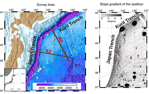
Figure 1. Left) Seismic survey lines for the deep-sea research vessel Kairei. Approximately 80 ocean bottom seismometers were placed at 6 km intervals along two track lines (A3, A2), nearly 500 km in length, each orthogonal to the Japan Trench and the Kuril Trench. Right) Slopes in the submarine topography. Visible structures parallel to the ridge axes, i.e., horst and graben structures, were observed in both trenches and were formed by the outer rise earthquake activity. However, their development processes were different in the two trench areas (details are also shown in Figures 3 and 4). The red dotted lines represent geomagnetic anomaly lineation and indicate past movements in the mid-ocean ridge, i.e., the past ridge is almost parallel to the current Kuril Trench and makes a larger angle with the Japan Trench.
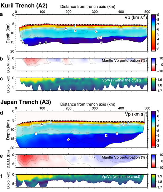
Figure 2. The results of seismic velocity structure analysis using ocean bottom seismometers: (a–c) Seismic velocity structure near the Kuril Trench, (d–f) Seismic velocity structure near the Japan Trench. (a, d) are P-wave velocity structures, (b, e) are deviations from the average seismic wave velocity structure in the oceanic mantle (red indicates slow speeds), and (c, f) are ratios between the P-wave velocity (Vp) and the S-wave velocity (Vs) within the oceanic crust. D.b.M. is the depth from Moho and D.b.b. is the depth from the sedimentary bedrock. For both trenches, the Vp decreases and the Vp/Vs ratio increases as the distance from the trench decreases. However, the magnitude and range of this change were greater near the Japan Trench. This difference likely indicates differences in the outer rise fault activity.
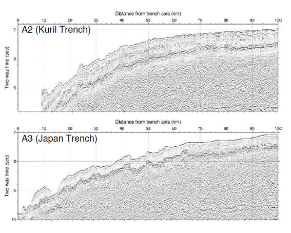
Figure 3. Structural cross sections near the trench axes (seismic time migrated reflection section). Prominent bumpy structures (horst and graben structures) are evident. These are considered to be formed by the outer rise fault activity and developed as the distance to the trench axis reduced. As indicated, relative elevation is higher in the Japan Trench area.
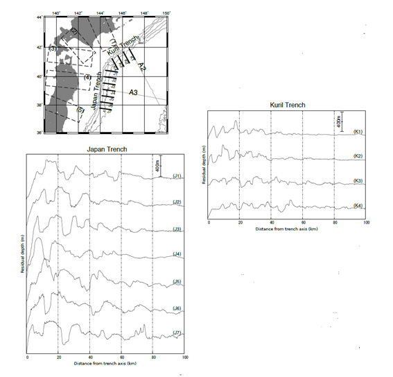
Figure 4. Detailed submarine topography of the Pacific Plate near the trench axes. Residual submarine topography is defined as the difference between the average submarine topography defined using a moving average and the actual submarine topography. The undulations are considered to have developed due to the activity of outer rise faults; the relative elevations of faults near the Japan Trench surpass 800 m, while those near the Kuril Trench are small with relative elevations below 400 m. Additionally, there is a prominent difference in the gaps between the faults. The gaps are over 15 km near the Japan Trench and approximately 4–5 km near the Kuril Trench. Since the curvatures in the plate due to subduction are similar, greater stress is concentrated at each fault near the Japan Trench (in comparison to those near the Kuril Trench), likely resulting in repeated activity in the same faults.
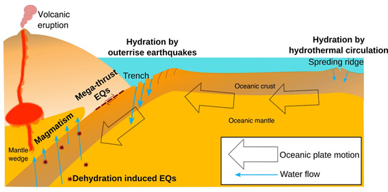
Figure 5. A schematic of oceanic plate subduction and the subsequent water transport. Oceanic plates transport water from the Earth’s surface to its deep parts. It is postulated that oceanic plates absorb water in areas near the mid-ocean ridges (where the plates are formed) and areas near outer rises (right before the plates disappear into the Earth’s interior). Seismic activity, magma formation, and volcanic eruptions are caused by the release of water transported by the plates into the depths.
Contacts:
- (For this study)
- Gou Fujie, Senior Research Scientist, Research and Development Center for Earthquake and Tsunami
- (For press release)
- Tsuyoshi Noguchi, Manager, Press Division, Public Relations