JAMSTEC News
Researcher Dirk Metz
Long-range underwater acoustic observations of the recent 2021 eruption at Fukutoku-Okanoba
A hydrophone station of the International Monitoring System recorded underwater sound waves associated with the August 2021 eruption at Fukutoku-Okanoba, an active submarine volcano in the southern Bonin Arc. Since low-frequency sound trapped in the Sound Fixing And Ranging channel travels hundreds to thousands of kilometers before dissipating, acoustic data recorded by the IMS station - which is located at a distance of more than 2,680 km from the volcano - can be used to continuously monitor activity at Fukutoku-Okanoba from afar and in near-real time. These observations highlight the potential of hydroacoustic measurements as a tool for remotely detecting and studying submarine volcanic eruptions in the global ocean.
Ocean Acoustics and the International Monitoring System
Underwater sound waves below a few hundred Hertz, generated, for instance, by earthquakes or in-water explosions, travel in the Sound Fixing And Ranging (SOFAR) channel, a layer of minimum sound speed in the oceanic water column that serves as an acoustic waveguide (Figure 1). The detection of such low-frequency signals is a key feature of the International Monitoring System (IMS), a global sensor network maintained as part of the verification regime for the Comprehensive Nuclear-Test-Ban Treaty of 1996. The objective of the IMS is to detect nuclear test explosions not only on land and in the atmosphere, but also in the ocean. In addition to seismic and infrasound sensors, the waveform component of the IMS therefore includes eleven hydroacoustic sites: Five land-based seismometers and six bottom-moored hydrophone triplet stations, the latter of which are typically deployed at the depth of the SOFAR channel axis offshore remote islands, thus increasing spatial coverage across ocean basins.
Recordings from IMS hydrophone stations have proven to be an invaluable asset for remotely studying a range of underwater acoustic phenomena, such as icebergs and sea ice drift[1], earthquakes[2], and, on occasion, submarine volcanic activity[3]. To investigate the initial stages of the recent eruption at Fukutoku-Okanoba, we analyzed waveform data from IMS station H11 at Wake Island in the western Pacific Ocean (Figure 2).
Recording the August 2021 eruption at Fukutoku-Okanoba
On 12 August 2021, Fukutoku-Okanoba, a shallow submarine volcano located circa 5 km offshore the island of Minami-Ioto in the southern Bonin Arc, entered a phase of intense activity. Reports based on satellite data and on-site observations so far have noted the generation of a large subaerial plume, discolored water, explosive degassing, and the repeated ejection of material over the course of multiple days. In addition, the eruption formed a small, temporary island.
As IMS hydrophone triplets are typically moored in a near-horizontal configuration, the delay times between elements can be used to invert for the direction of arrival. Figure 3 shows that shortly after 21:00 UTC on 12 August 2021, back azimuths of the time windowed data recorded by the H11S triplet begin to stabilize at 288°, indicating the presence of a coherent acoustic source in a direction consistent with the geodesic path towards Fukutoku-Okanoba. Thousands of arrivals from the direction of the volcano are recorded over the following days, suggesting that acoustically detectable activity occurred more or less continuously until at least mid-day on 15 August, after which rates drop to less than a dozen events per day.
A broadband impulse, observed around 21:25 UTC on 12 August, features prominently in Figure 3. Accounting for the acoustic travel time from the volcano to the Wake Island station, i.e. 30-min at a source-receiver distance of 2,680 km and a propagation speed of 1.48 km/s, the impulse must have occurred just a few minutes before the distinct subaerial plume had first been detected by the Himawari-8 geostationary satellite[4]. The observations, therefore, could be connected to the same climactic event at the beginning of the eruption. This example shows that future investigations might indeed benefit from the combination of datasets across disciplines to derive a more complete picture of the eruption dynamics. As recent observations suggest that activity at Fukutoku-Okanoba could have resurged after 15 August, it would also be important to extend the time series beyond the initial stages of the episode that have been studied here.
Disclaimer
The views expressed in this publication are those of the author(s) and do not necessarily reflect those of the Preparatory Commission for the CTBTO.
Corresponding research article:
https://www.jstage.jst.go.jp/article/ast/43/2/43_E2165/_article/-char/ja
References
- [1]
- L. G. Evers, D. N. Green, N. W. Young, M. Snellen (2013), Remote hydroacoustic sensing of large icebergs in the Indian Ocean: Implications for iceberg monitoring, Geophys. Res. Lett., Vol. 40, 4694-4699
- [2]
- J. Guilbert, J. Vergoz, E. Schisselé, A. Roueff, Y. Cansi (2005), Use of hydroacoustic and seismic arrays to observe rupture propagation and source extent of the Mw = 9.0 Sumatra earthquake, Geophys. Res. Lett., Vol. 32, L15310
- [3]
- H. Matsumoto, M. Zampolli, G. Haralabus, J. Stanley, J. Mattila, N. M. Özel (2019), Interpretation of detections of volcanic activity at Ioto Island obtained from in situ seismometers and remote hydrophones of the International Monitoring System, Sci. Rep., Vol. 9, 19519
- [4]
- Tokyo Volcanic Ash Advisory Center (2021), VA Advisory for Volcano 284130 Fukutoku-Oka-No-Ba (Nr. 2021/1, issued at 20210813/0027Z)
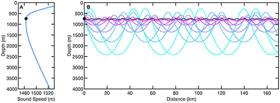
Figure 1: Simplified view of the SOFAR channel domain. Ray tracing results using the sound speed profile shown in (A) illustrate long-range acoustic propagation in a typical deep-water waveguide without range-dependence. The point source (black circle) is positioned near the sound speed minimum at 740 m depth.
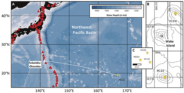
Figure 2: Location of Fukutoku-Okanoba (white triangle) and IMS hydrophone station H11 (yellow star) in the western Pacific Ocean. The station consists of two bottom-moored hydrophone triplets, H11N and H11S, installed 50 km north and 90 km south of Wake Island, respectively. Triplet elements are moored near the SOFAR channel axis at ~740 m below sea level. The source-receiver distance from the IMS station to the volcano, marked by the solid white line in (A), is approximately 2,680 km.
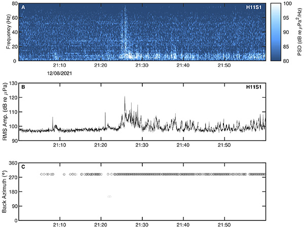
Figure 3: 60-min long spectrogram and 1-sec RMS amplitude of waveform data recorded by hydrophone element H11S1 at Wake Island, beginning at 21:00 UTC on 12 August 2021. Data are correct for the instrument response and band-pass filtered between 2 and 80 Hz. Note the distinct presence of arrivals in the 2-12 Hz band following the broadband impulse recorded at 21:25 UTC. Circles shown in (C) mark non-overlapping time windows of 10-sec length. Back azimuths are measured clockwise from north.