Research Institute for Marine Geodynamics (IMG)

Elucidating the occurrence and processes of earthquakes and volcanic activities in marine areas for disaster mitigation
The Institute for Marine Geodynamics (IMG) conducts large-scale research and observation using JAMSTEC-owned research vessels and observation equipment to elucidate the occurrence of and circumstances affecting earthquakes and volcanic activities. In addition, highly accurate numerical simulations are conducted to predict the future trends of these activities. These data and information are provided to the government and related organizations to mitigate disasters.
- 2025/04/25
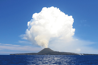
- Observation of a remote island volcano by an unmanned helicopter taking off from a research vessel and operated remotely via satellite communications (flash report)
- 2025/03/14
- Second Joint International Earthquake Science Symposium
- 2025/02/26
- Researcher Ychen Wang receives the Kamide Lecture Award
- 2024/08/22
- Exploration of the accumulation of magma in Kikai Caldera from the Chikyu submarine cores
- 2024/05/31
- Recognized as Top Cited Article
- 2023/09/20
- Discovery of fluid conduits that extend from the plate boundary fault hosting slow earthquakes to the seafloor
- Successful imaging of the upper-plate fracture zones formed by a subducting ridge - - 2023/07/19
- A theoretical model of continental drift reveals that the longest timescale of sea level change in Earth's history can be explained by the flattening effect of the seafloor
- Toward an understanding of the relationship between Earth's internal dynamics and surface environmental change - - 2023/05/25
- Did a coalition of giant volcanoes occur in the Pacific Ocean?
New evidence for the Ontong Java Nui hypothesis - 2023/02/01
- Data assimilation using high-frequency radar for tsunami early warning: A case study of the 2022 Tonga volcanic tsunami
- 2023/01/20
- Symposium on D/V CHIKYU borehole observatory cruise (February 24)
- 2019/06/07
- Research Institute for Marine Geodynamics (IMG) website has been launched.
Tackling Earthquakes and Volcanoes in the World's Oceans
The Institute for Marine Geodynamics (IMG) challenges Earthquakes and Volcanoes not only in Japan but also in the world.
We sail to the seas around Japan and around the world to conduct research and exploration to elucidate the phenomena of earthquakes, tsunamis, and volcanic eruptions.
Main Research Areas(JAPAN)
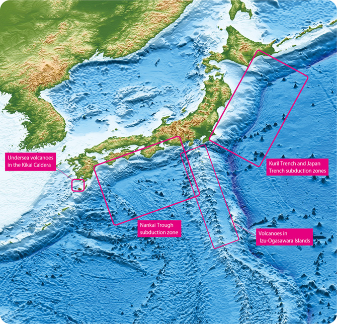
- Kuril Trench
- We investigate crustal structure, sesimic activities, and deformation processes to elucidate the megathurst earthquakesin this subduction zone.
- Japan Trench
- We investigate crustal structure, sesimic activities, and deformation processes to elucidate the megathurst earthquakes, such as the 2011 Tohoku earthquake.
- Nankai Trough
- We investigate crustal structure by extensive seismic exploration and observe crustal activities by developing monitoring system to elucidate and forecast the preparation, rupture and deformation processes of the megathrust earthquakes.
- Kikai Caldera
- We conduct structural exploration and collection and analysis of volcanic ejecta to investigate the conditions leading to past eruptive activities and understand the potential damage that the volcano may pose to society in the future.
- Izu-Ogasawara Islands
- We study the processes leading to eruptions and investigate the transition in eruptive activity by analyzing ejecta samples and conducting structural exploration.
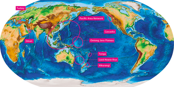
Main Research Areas(WORLD)
Medley, P. R., CIRES, University of Colorado at Boulder, 2009
http://www.ngdc.noaa.gov/mgg/global/global.html
Accessed 05.08.2022
- Turkey
- We conduct seafloor seismic observations in the Marmara Sea to study the geometry of faults that pass beneath the seafloor and the actual state of seismic activity.
- Oman
- We study the crust-mantle boundary by examining the largest oceanic lithosphere (ophiolites) exposure on land.
- Pacific Area Network
- We conduct geophysical observations to contribute to the early detection of earthquakes and to tsunami forecasting in the western Pacific region.
- Ontong Java Plateau
- We conduct comprehensive research on the formation and origin of the largest oceanic volcanic edifice on Earth.
- Tonga
- We conduct research on the eruption process of submarine volcanoes using pumice and other materials ejected during volcanic eruptions.
- Lord Howie Rise
- We investigate the crustal structure and crustal deformation to understand the mechanism of continental breakup.
- Hikurangi
- We examine the crustal structure and crustal deformation of a mega seismic zone to explore the earthquake generation processes caused by crustal deformation.
- Cascadia
- We investigate the effects of seamount subduction on earthquake generation zones.

Shigeaki Ono
Director-General, Research Institute for Marine Geodynamics (IMG)
We are committed to learn about the past, present, and future of the living Earth and explore the relationship between Earth activities and human society.