Volume Data Visualizer for Google EarthTM (VDVGE)
Volume Data Visualizer for Google EarthTM (VDVGE) is a software to visualize data for GrADS, plotting tool for earth science data, and to export the visualiztion result for Google EarthTM. EXTRAWING, volume-rendering-like representation on Google EarthTM using KML and COLLADA files, can be produced through GUI-based simple operations. With Qt SDK, a multi-platform GUI toolkit, VDVGE runs on Microsoft Windows, Mac OS X and Linux.
EXTRAWING(Web Application)
Screenshots

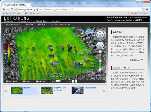
A screenshot of VDVGE
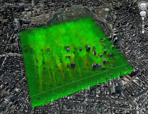
A screenshot of visualization result using exported files by VDVGE
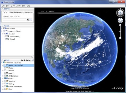
A screenshot of visualization result using exported files by VDVGE
Download
Volume Data Visualizer for Google Earth Ver. 1.1.8 [New!!]
-
Source Code
vdvge-1.1.8-source.zip (zip)
Volume Data Visualizer for Google Earth Ver. 1.1.7
* RPM packages were contributed by Tsuyoshi Yamaura (RIKEN/AICS).
-
Source Code
vdvge-1.1.7-source.zip (zip)
vdvge-1.1.7-1.src.rpm (SRPM)
vdvge-1.1.7-source.tar.gz (tar+gzip) -
Executable Binary
vdvge-1.1.7-windows.zip (for Microsoft Windows)
vdvge-1.1.7-1.CentOS.x86_64.rpm (CentOS 6 (x86_64))
vdvge-1.1.7-macosx.dmg (for Mac OS X)
vdvge-1.1.7-1.Fedora.x86_64.rpm (Fedora 20 (x86_64))
vdvge-1.1.7-1.openSUSE.x86_64.rpm (openSUSE 13 (x86_64))
vdvge-1.1.7-1.Vine.x86_64.rpm (Vine Linux 6 (x86_64)) -
Sample Data (Cloud Water, AFES)
vdvge-sample.zip (zip)
vdvge-sample.tar.gz (tar+gzip)
This sample data is outputted by the general circulation model called AFES (AGCM for the Earth Simulators). -
Manual(PDF)
History
2015/05/26: Ver. 1.1.8 New!!
-
Added command line execution mode.
% vdvge (hoge.ctl) (hoge.save)
or
% vdvge (hoge.ctl) (hoge.save) (hoge.colortable)
A content file for Google Earth will be exported without launch GUI window.
- Added a function to set time difference from GMT.
2014/07/10
- Added RPM packages. (contributed by Tsuyoshi Yamaura (RIKEN/AICS))
2014/04/18: Ver. 1.1.7
- Added a drawing function of topography and coastline (in preview windows only).
- Fixed a problem that did not work with some models of Macbook Air.
- Fixed a problem that the vertical color bar was not drawn correctly with some of graphics boards.
- Executable file (Windows and Mac OS X) is now available for download.
2013/08/09: Ver. 1.1.4
- Added a drawing function of contourline.
- GLEW and GLUT is no longer needed.
2012/12/25 (Ver. 1.1.1)
- Fixed a problem with the save file is not loaded correctly.
2012/12/14 (Ver. 1.1)
- 1st Release.
Restrictions of input data
The GrADS data for VDVGE has the following restrictions.
- The file specified in the keyword "DSET" in the GrADS control file should be unformatted FORTRAN binary (single-precision).
- The GrADS control file can have only a single scalar field, i.e. only one parameter in the keyword "VARS".
- Unit of "ZDEF" must be written in actual altitude (meter of kilometer).
- The option "TEMPLATE" is not supported.
Requirement
- Qt4 is required to compile VDVGE. Please refer the manual about how to compile.
- ffmpeg is required if you use the movie export function.
- ETOPO1, ETOPO2, ETOPO5 and GEODAS Coastline is required if you use the topography drawing function and the coastline drawing function.
- Graphics hardware that supports OpenGL 1.2 or higher is required.
License
- This software is released under GPL Ver3.0 license.
- Sample codes included in Qt SDK are changed and used for a part of source code of this software. About the appropriate file, it has written in the header of the source code.