Press Releases
JAMSTEC
National Museum of Nature and Science
UNIVERSITY OF CANTERBURY
Revealing past eruptions of Oomurodashi volcano, an active submarine volcano 60 km from Tokyo Bay
1. Key Points
- ◆
- Chemical composition of pumice contained in ash layers on the islands of Izu-Oshima and Toshima confirms that this ash was produced by a shallow submarine eruption of Oomurodashi volcano 13,500 years ago.
- ◆
- Developed a new method to estimate the age of volcanic rocks collected directly from the seabed using the concentration of water dissolved in lava.
- ◆
- Applying this method to lava collected by submarine surveys of Oomurodashi, it was revealed that a submarine eruption occurred about 7,000 to 10,000 years ago, when sea level was lower than today.
2. Overview
Japan Agency for Marine-Earth Science and Technology (hereafter referred to as “JAMSTEC”; Chairman: Hiroyuki Yamato) Researcher Iona McIntosh of the Volcanoes and Earth’s Interior Research Center, Research Institute for Marine Geodynamics, in collaboration with researchers from the National Museum of Nature and Science and University of Canterbury, New Zealand, has used analyses of lava and pumice collected from the submarine Oomurodashi volcano and nearby islands to reveal the past eruptive activity of Oomurodashi. First, the chemical composition of submarine rocks collected from Oomurodashi by Remotely Operated Vehicle (ROV) during surveys by R/V Natsushima and R/V Shinsei-maru were compared with the chemical composition of pumice found on the neighbouring islands of Izu-Oshima and Toshima. Based on the similarity of the chemical compositions, it was confirmed that these ash layers were caused by a shallow submarine eruption of Oomurodashi that happened 13,500 years ago. In addition, in order to investigate the possibility of other eruptive activity, they developed a method to estimate eruption ages of seafloor lava based on the amount of dissolved water contained in the lava. Analysing a seafloor lava sample of Oomurodashi in this way, they found that eruptive activity occurred about 7,000 – 10,000 years ago. The same type of analysis was used for samples of pumice also collected from the seafloor, which revealed that past eruptive activity has included eruption of pumice reaching shallow water depths. This is an important research result for providing insight into the eruption history of an active submarine volcano near Tokyo Bay and for evaluating the activity of many submarine volcanoes in the waters near Japan.
This research was supported by the Grant-in-Aid for Scientific Research (JP00470120, 16K05584).
This result will be published in "Geology" on June 29 (Japan time).
- Japan Agency for Marine-Earth Science and Technology (JAMSTEC)
- National Museum of Nature and Science, Tsukuba
- School of Earth and Environment, University of Canterbury, New Zealand
3. Background
Oomurodashi volcano is a shallow submarine volcano located between Izu-Oshima and Toshima islands, 60 km southwest of the entrance to Tokyo Bay, at a water depth of ~120 meters below sea-level (Figure 1). This volcano is not included in the list of active volcanoes designated by the Japan Meteorological Agency, but in a marine survey conducted by R/V Natsushima of the Japan Agency for Marine-Earth Science and Technology (JAMSTEC) in 2012 an active hydrothermal field was discovered at the bottom of its central crater at a water depth of ~200 m (Tani et al; Abstract of the American Geophysical Union 2013). During this voyage and a subsequent survey by the R/V Shinsei-maru in 2016, researchers succeeded in collecting rock samples such as lava and pumice from the seafloor using a Remotely Operated Vehicle (ROV) (Figure 2). Although these volcanic rocks looked fresh and geologically recent, it is important to know the exact date of the eruption to assess volcanic activity and the potential hazard posed by this volcano. However, it is difficult to determine the age of rocks younger than tens of thousands of years using the radioactive decay of potassium, which is typically used to date rocks. For terrestrial deposits, it is possible to determine ages of 50,000 years or less using the radiocarbon dating method (*1), but this method cannot be used for lava erupted on the seafloor due to a lack of suitable material in this environment. A new dating method was therefore needed to clarify the past eruption histories of submarine volcanoes such as Oomurodashi.
4. Outcome
To investigate how Oomurodashi has erupted in the past, researchers at JAMSTEC, the National Museum for Nature and Science and the University of Canterbury in New Zealand performed various analyses of the retrieved samples. The chemical composition of rocks collected from Oomurodashi was measured and compared with the chemical composition of various volcanic ash (tephra) layers found on nearby islands. They found that the chemical composition of Oomurodashi is consistent with the composition of pumice in a tephra layer in a famous outcrop on Izu-Oshima (Figure 3) as well as with pumice in a tephra layer on Toshima. These tephra layers had been found to be ~13,500 years old by radiocarbon dating, but their eruption origin was unknown. Due to the consistency of the chemical compositions, it was confirmed that an explosive shallow submarine eruption of Oomurodashi about 13,500 years ago caused volcanic ash and pumice to fall on Izu-Oshima and Toshima.
In contrast to terrestrial tephra layers, it has not been possible to determine the eruption age of submarine lava and pumice for relatively young submarine volcanoes. Therefore, in order to date submarine eruption deposits from the last few tens of thousands of years, they developed a new method for estimating the eruption age from the amount of water contained in volcanic rocks. In this method, the concentration of water dissolved in lava (*2) is measured using an instrument called a Fourier transform infrared spectrophotometer (known as FTIR). Since the concentration of water dissolved in lava erupted onto the seafloor changes according to the surrounding pressure (water pressure) at that time, it is possible to estimate the depth below sea level at the time of eruption from the measurement of the lava’s water content.
When two lava samples, collected from the seafloor of Oomurodashi, were analysed using this method, the water depth at the time of eruption estimated from their dissolved water content is shallower than the water depth at which the samples were actually collected from the seafloor in the present day. This apparent difference in water depth can be explained by the eruption of lava occurring when the sea level was lower than it is today (Figure 4). As a result of comparing the water depth estimated from the lava’s dissolved water concentration with the regional sea level change curve (*3), one lava was estimated to be erupted about 14,000 years ago and another lava was estimated to be erupted about 7,000 – 10,000 years ago.
Similar FTIR analysis was also performed on pumice samples collected from the seafloor. Unlike lava flows that erupt along the seafloor, pumice can rise in water, so it is not possible to compare the concentration of dissolved water in pumice with sea-level changes to determine the eruption age. However, the water content of pumice instead records how high it rose in the water during the eruption. Some of the relatively dense pumice rocks collected at Oomurodashi recorded water pressure close to the depth of the crater, but other pumice rocks have very little remaining dissolved water, indicating that they reached shallow pressures close to the sea surface. These results show that in the past Oomurodashi has caused an eruption of pumice that reached shallow water depths or even into the air itself. Eruptions in shallow water, such as the eruption of Fukutoku-Oka-no-Ba that occurred in 2021, can often generate drifting floating pumice called pumice rafts (see column :Pumice raft from Tongan submarine volcano). Since floating pumice are carried away from their source volcano it is not confirmed whether Oomurodashi has made pumice rafts in the past, but these findings suggest that it is possible.
5. Future prospects
From this study, it has become clear that Oomurodashi has had a submarine eruption within the past 10,000 years. In addition, signs of activity such as the existence of hydrothermal vents in the central crater are still ongoing, and there is a possibility that volcanic activity could pose hazards to the surrounding sea area and nearby islands in the future.
There are many active submarine volcanoes in shallow water, not only in Japan, but also across the world’s oceans. However, how they erupt, how often they erupt and the hazards they pose are not well understood. The new approach of estimating the age of submarine lava by comparing the dissolved water concentration of the lava with past sea level fluctuations is expected to be useful for elucidating the activity history of other submarine volcanoes. In addition, by applying Fourier transform infrared spectroscopic analysis to submarine pumice, information such as the style and magnitude of the eruption can be obtained. Currently, we are applying this method to the pumice rocks of the 2021 eruption of Fukutoku-Oka-no-Ba, and are studying the eruption mechanism of the pumice rafts that caused a major disaster in the Japanese islands. In the future, it is hoped similar analyses will assist in investigation of other hazardous volcanoes, such as the Hunga Tonga-Hunga Ha’apai volcano that erupted catastrophically in January 2022.
- *1
- Radiocarbon dating method:
A dating method using radioactive carbon (14C) contained in organic carbon found in soil and carbonized wood. Although volcanic rock itself does not contain organic carbon, the eruption age of volcanic rock can be estimated by applying this dating method to the organic carbon contained in the layers deposited above and below the volcanic rock. Similar dating can be performed using organic carbon derived from organisms such as foraminifera in seafloor sediments, but this dating method is rarely applicable to lava collected from the seafloor because it is not sandwiched between sedimentary layers.
- *2
- Fourier transform infrared spectrophotometer:
This device, also called FTIR, is widely applied for various component analysis, but in this study, it was used to measure the concentration of water in volcanic rocks. In rocks, water derived from magmatic gases exists in two forms: H2O molecules and OH groups. Of these, H2O molecules can also diffuse into rocks from surrounding seawater, so the amount of H2O molecules in rocks that have existed in the sea for a long time increases (hydration). However, the amount of OH groups is not increased by hydration, so in this study, the concentration of OH group was measured by FTIR.
- *3
- Sea level change curve:
It is known that sea level changes over time. During the Last Glacial Maximum (about 20,000 years ago), the sea level in this region was about 120 m lower than it is now. Sea level then rose during the Holocene as ice sheets retreated, until the present day sea level was reached around 7,000 years ago.
References
Tani et al (2013) Discovery of an active shallow submarine silicic volcano in the northern Izu-Bonin Arc: volcanic structure and potential hazards of Oomurodashi Volcano, Abstract V33H-05 presented at 2013 Fall Meeting, AGU, San Francisco, Calif., 9-13 Dec
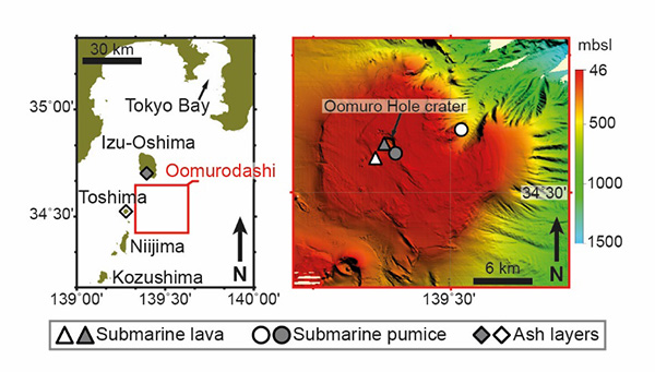
Figure 1 Location of Oomurodashi, a shallow submarine volcano about 60 km south of the entrance to Tokyo Bay. A detailed topographic map of the submarine volcano was created by the oceanographic survey, and rock samples were collected by the Remotely Operated Vehicle (ROV) "Hyper-Dolphin" (right figure; the symbols show the location of various samples). The wide flat summit of Oomurodashi is located 120 m below sea level, and in the center there is a crater called Oomuro Hole, which reaches 200 m below sea level. It was found that there is an active hydrothermal vent at the bottom of this crater, and lava and pumice deposits are widely distributed on the crater wall and flat summit. The diamonds in the figure on the left indicate the location of the volcanic ash layer (about 13,500 years ago) derived from Oomurodashi on nearby Izu Oshima and Toshima.
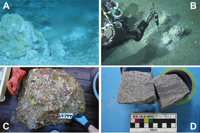
Figure 2 Seafloor images of Oomurodashi and collected rock samples. In the Oomuro Hole crater, a hydrothermal field with active chimneys that release hot fluids and gases were discovered (A), and the temperature of the seafloor was also measured by ROV (B). An example of a lava block collected from the summit of Oomurodashi (C), which when cut with a rock cutter was found to be rhyolite with many small gas bubbles (D).
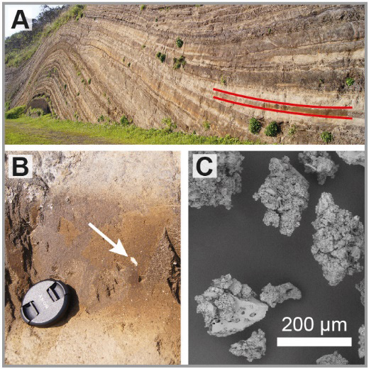
Figure 3 Volcanic ash layer derived from Oomurodashi found on Izu Oshima. A: The "important cross section of the geological formation" of Izu Oshima and the volcanic ash (tephra) layer (shown between red lines) identified as derived from Oomurodashi by this study. B: Enlarged view of this ash layer. White pumice fragments can be seen within the fine-grained volcanic ash. The chemical composition of the pumice was consistent with the chemical composition of the rocks taken from the Oomurodashi submarine volcano, indicating that this tephra layer was formed by the explosive eruption of Oomurodashi. C: Particles of volcanic ash imaged with a scanning electron microscope (SEM). These particles are aggregates of smaller particles, indicating that the ejected magma interacted with the surrounding seawater.
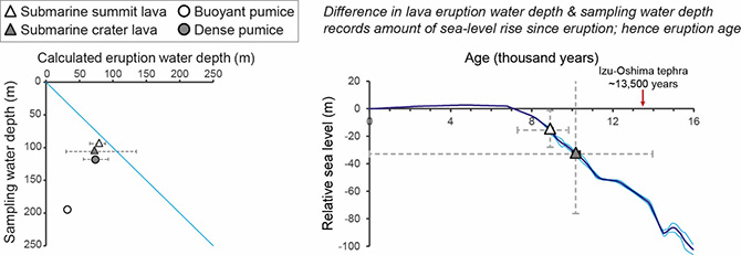
Figure 4 Analysis results of dissolved water content of lava and pumice collected from Oomurodashi. Left figure: Comparison of the water depth at which rocks were sampled (left axis) against the water depth of eruption calculated from dissolved water content of the rock (top axis). Submarine lavas (triangle symbols) were erupted in shallower water than today. Pumice samples (circles) reached different depths depending on their buoyancy, with the most buoyant pumice reaching about 30 m below the sea surface. Right figure: Regional sea level change curve. During the Last Glacial Maximum (about 20,000 years ago), the sea level near Japan was 120 m lower than it is now, and then the sea level rose and reached near the current sea level about 7,000 years ago (Holocene glacial retreat). By comparing the water pressure at the time of eruption estimated from the concentration of water in the lava and the sea level change curve, it is estimated that the lava (white triangle) at the summit of Oomurodashi erupted 7,000 to 10,000 years ago. The lava near the crater (grey triangle) has a large error in the estimation due to the large analysis error, but it is estimated to be just older than 13,500 years old, which is the same as the volcanic ash derived from Oomurodashi found in Izu Oshima and Toshima.
Contacts
- (For this study)
- Iona McIntosh, Researcher, Research Institute for Marine Geodynamics(IMG), Volcanoes and Earth’s Interior Research Center(VERC), Solid Earth Geochemistry Research Group, JAMSTEC
- (For press release)
- Press Office, Marine Science and Technology Strategy Department, JAMSTEC