JAMSTEC News
Researcher Iona McIntosh
Pumice raft from Tongan submarine volcano
Pumice rafts in the world
The floating pumice raft from Fukutoku-Okanoba that is now arriving in the Okinawan islands is the latest example of how unseen underwater volcanoes can affect coastal communities, even many weeks after and hundreds of miles away from the eruption itself. Since 2000, there have been several notable pumice raft events around the world. These include the surprising eruption of Havre volcano in the Kermadec Arc in 2012, which created a large pumice raft even though the volcano itself is 900 metres below the sea surface. Other rafts have been caused by shallower volcanoes that are closer to the sea surface, similar to Fukutoku-Okanoba. Several of these occurred in the Kingdom of Tonga: pumice rafts from Volcano 0403-091 in 2001 and 2019, and from Home Reef in 2006, travelled from Tonga across the Pacific, passing through the Fiji islands before ultimately arriving on the east coast of Australia months later.
Eruption of the submarine volcano named ‘0403-091’ in 2019
In early 2020 I joined an international group of researchers led by Dr Isobel Yeo from the National Oceanography Centre in the UK to investigate the 2019 eruption of the curiously named Volcano 0403-091 and the impacts of its pumice raft. Volcano 0403-091 is 45 km north of the island of Vava’u, and is 40 metres below sea level at its shallowest point. The first sign of its August eruption was when sailing boats encountered a pumice raft on 15th August, but at that time no one knew which volcano had erupted. By looking through satellite images, it was discovered that the raft came from Volcano 0403-091 which had erupted on the 6th August. The raft covered over 100 km2 of the ocean surface and was made up of pieces of pumice ranging in size from small pebbles to 80 cm, forming a layer roughly 30 cm thick.
The raft drifted on the ocean surface in a direction controlled by the strength and direction of ocean currents and surface winds. It travelled westwards away from Tonga, gradually stretching out into long thin twisting ribbons of pumice over 50 km in length. Within 3 weeks it had travelled over 200 km from the volcano, and by 4 weeks it had arrived in Lakeba in the Fiji islands. It continued travelling through the Fiji islands throughout September 2019, and a year later in August 2020 it finally arrived on the east coast of Australia, more than 3000 km from Volcano 0403-091.
In February 2020 our group of researchers arrived in Tonga to conduct a marine survey of the shallow summit of Volcano 0403-091. In collaboration with members of the Tongan Ministry of Lands and Natural Resources and the Vava’u Environmental Protection Association, we hired a small sports fishing boat to travel to the site of the volcano. We travelled back and forth over the shallow summit using the boat’s single beam profiler to measure the water depth underneath us and thus to see how the shape of the volcano had changed after the eruption. We used a Remotely Operated Vehicle or ROV (a small underwater robot that can travel along the seafloor recording video) to look at the newly erupted volcanic rocks covering the seafloor, and also the bacterial mats, crustaceans and fish that were already coming back to live in the area 6 months after the eruption. Finally, we used a dredge (a metal box that drags along the seafloor scooping up material) and sediment grab sampler with attached cameras to bring up samples of the rocks on the seafloor for us to analyse in the laboratory afterwards.
Our survey found that the eruption had created a new crater to the west of the pre-existing craters on the shallow summit. The floor of this crater was 120 m below sea level, and contained loose volcanic rocks of up to 1 metre in size. Using our dredge we were able to retrieve some of these rocks for study. These were grey pumice rocks, containing many bubbles from the gases in the magma when it erupted. Unlike the pumice rocks in the pumice raft, however, these pumice rocks did not have enough gas bubbles to make them float in water. Instead, these denser rocks sank to the seafloor to fill the crater and cover the surrounding seafloor. From our survey, we estimate that ~0.03 km3 of new volcanic material was added to the summit of the volcano by the eruption. This compares with the estimated ~0.02 - 0.04 km3 of volcanic material that went into the pumice raft. This shows that the pumice rafts produced by these volcanoes can be a significant amount of the total erupted material. It also highlights some of the difficulties of investigating past eruptions of submarine volcanoes – if pumice rafts can be so large and travel so far from their source volcano, how can we recognise which volcanoes have produced rafts in the past and therefore might be likely to produce them again in the future? We are now studying our samples of the rocks left behind on the seafloor to see if their characteristics (e.g. size, amount of bubbles, appearance) can be used as evidence to identify past raft-forming eruptions from seafloor deposits at other volcanoes.
Survey of the pumice raft deposits in Fiji
Of course, one of the most important questions is what controls whether an eruption will produce pumice or not? How much depends on the magma chemistry, the amount of gas it contains, how fast the magma rises to the surface, how deep underwater is the volcano, and so on? What exactly are the differences between the rocks that sink around the volcano, and the rocks that float away in the pumice raft? And how do pumice rafts change as they travel – when and how will they finally sink? To answer these questions, and to find out more about the impacts of pumice rafts in the areas where they arrive, we travelled to islands in Fiji that were affected by the pumice. Joined by a member of the Fiji Ministry of Lands and Mineral Resources, we travelled to Lakeba island in eastern Fiji, which was the first to be affected by the pumice, and then to the Yasawa islands in the west, where the pumice arrived 3 weeks later.
Both Lakeba and the Yasawa islands were significantly affected by the pumice raft. The pumice arrived suddenly, with the entire coastline filled with pumice within a day. Brought into the coastline by the tide, the pumice formed such a thick layer that grown men could walk out across the pumice without falling through into the water below. Lakeba island is surrounded by a shallow fringing reef. When the tide went out, it took some pumice out with it, but a large amount of pumice remained trapped between the coastline and the reef and simply covered the seafloor as the water drained away with the tide. When the tide came back in again, the pumice was once again brought in against the coastline. The pumice was finally mostly removed from the coastline when the wind direction changed so that it was no longer blowing onshore. Then, the tide took the pumice out to sea and it drifted away from the island, so that the majority of the pumice was removed from Lakeba within a few days. Local people told us that there was a difference between areas of open beaches, where the majority of pumice was removed quite quickly, and areas of mangroves, where the pumice became trapped within the roots of the mangrove trees and took longer to be removed.
In the Yasawa islands, the pumice also arrived suddenly. These islands have deep bays, which became thickly filled with pumice, forcing the local people to walk out a long way over the pumice to access the open sea. Unlike Lakeba, however, this thick pumice layer remained at the coastline for many months because of the strong, constant winds that consistently pushed the pumice towards the coastline. Due to the shape of the coastline, it was only when the season changed and the onshore winds weakened that the pumice could finally move out to the open sea again and drift away.
When we arrived ~5 months after the arrival of the pumice raft, the vast majority of the pumice had already been removed, but both Lakeba and Yasawa still had many patches of pumice along their coastlines. This pumice looks very similar to the rocks that we collected from the volcano summit, but had a higher number of bubbles, many of which were very small. It is likely that these very small bubbles are difficult to fill with seawater, which helps the pumice to stay floating even after many weeks in the ocean. We will be examining these bubbles in detail using techniques like X-ray Computed Tomography (XRCT) to help us understand these processes. We found that the pumice in the Yasawa islands, which had travelled further than the pumice in Lakeba, was on average slightly smaller than the pumice in Lakeba. This may be because the pumice breaks up into smaller pieces along cracks and other weaknesses while it travels in the raft. However, in both locations we still found some pieces at least 30 cm in size.
It was noticeable that even 5 months later, there were still small patches of pumice floating in the sea around these islands. Some of this is pumice that is repeatedly deposited on the coastline and then picked up again by the tide. However, in Yasawa the local people also explained to us that the change in seasons caused a kind of ‘second pumice raft’ event. When the raft first arrived, it was the dry season so there was very little water flowing in the rivers. The pumice was therefore able to travel far up the river channels and stay there. When the rainy season arrived, the increased flow of the rivers was finally able to wash all this pumice back out to sea, so that there was a second influx of pumice along the coastline.
We also asked local divers and fishermen if there was any pumice that had sunken to the seafloor, and did some underwater video transects around the coastline looking for sunken pumice. Although we saw a few pieces that had sunk, the local divers said that they had seen very few pieces of sunken pumice on the seafloor, even in places in Yasawa where the pumice filled the bays for several months. This suggests that most pumice will remain floating without filling with seawater and sinking for a very long time, and/or that any pumice that did sink was also removed from the coastline by tides and underwater currents.
Impact of pumice rafts on nature and human activity
When we asked people living in these areas about how they were affected by the pumice raft, they told us of several different impacts. Some people using small boats with outboard motors found that the engine stopped because small pieces of pumice had blocked the water intake pipes (they also found that the pumice cleaned and sharpened the blades of their propellors!). People therefore were not able to use these boats to travel or go fishing, unless they were able to carry it over the pumice to open water or push themselves through the pumice using a long pole. In Lakeba, the boat that brings food and fuel supplies was prevented by the pumice from entering the usual harbour, so the islanders had to offload the fuel drums elsewhere and then push them up the hill. Fishermen found that nets and traps were destroyed by the pumice, and this also affected the traps used to catch crabs within the mangroves. The mangrove trees themselves were mostly unaffected by the thick pumice, but an area of mangrove seedlings that had been planted to reduce the impact of storms was destroyed. When the thick raft first arrived at the coast, fish were seen jumping out of the water and dying when they landed on the surface of the raft and could not return to the water. In Lakeba, dead sea turtles were found with damage to their shells and pumice blocking their throats, suggesting that they had been trapped underneath the thick pumice when the tide went out. In the Yasawa islands fishermen told us that the reefs had been damaged by the constant scraping of the thick pumice layer, and local people employed providing tourist accommodation told us that their businesses had suffered because tourists did not want to visit when the usually pristine white beaches were covered by pumice. On a more positive note, many local people took advantage of the pumice as a source of free construction material, using it to repair holes in roads, fill septic tanks, and store for future buildings.
Although the impacts of pumice rafts will vary from place to place, due to differences in the amount of pumice, duration of pumice inundation, and characteristics of coastal communities (such as their socioeconomic reliance on shipping, fishing, tourism etc), the reported impacts of this 2019 raft in Fiji are a useful illustration of how the pumice raft from Fukutoku-Okanoba may affect Okinawa and other parts of the Japanese coastline. Researchers at JAMSTEC and other institutions are now studying the pumice from Fukutoku-Okanoba to learn about the eruption processes that created it. Meanwhile, researchers are observing the way the pumice is transported by ocean currents and surface winds, and developing computer models that may help us to better predict the ongoing dispersal of the pumice. By doing so, we hope to improve our ability to warn people in coastal communities before pumice arrives, to reduce the impacts of pumice rafts, and to understand how future pumice raft events may occur.
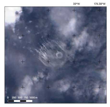
Fig.1 Sentinel-2 (ESA) satellite image that captured evidence of eruptive activity at Volcano 0403-091 on 6th August 2019
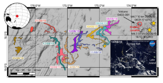
Fig.2 Map showing location of Volcano 0403-091 and the dispersal of the pumice raft (mapped from satellite images) during the first three weeks after the eruption.
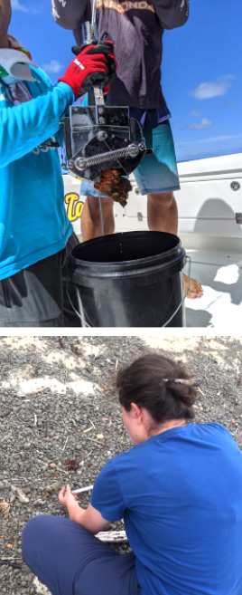
Fig.3 Top: A piece of orange-stained dense pumice collected from the volcano summit using a sediment grab sampler. Bottom: Collecting representative raft pumice from the Lakeba coastline.
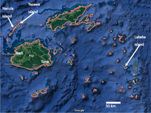
Fig.4 Google Earth image showing the islands of Fiji and the locations of our survey.
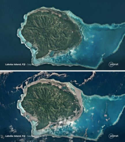
Fig.5 Two satellite images released by Planet Labs showing Lakeba island before and after the arrival of the pumice raft.
Global Volcanism Program, 2019. Report on Unnamed (Tonga) (Krippner, J.B., and Venzke, E., eds.). Bulletin of the Global Volcanism Network, 44:11. Smithsonian Institution.
https://doi.org/10.5479/si.GVP.BGVN201911-243091
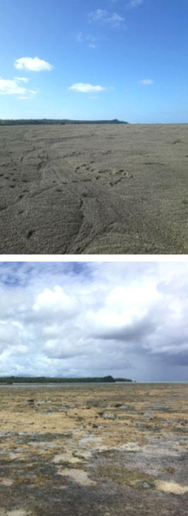
Fig.6 Top: The harbour area of Lakeba during the pumice raft event. Footsteps can be seen where people were able to walk out across the top of the thick pumice layer. The jetty for ships can be seen in the distance on the left. Bottom: The same area of Lakeba photographed 5 months after the raft event. The photograph was taken at low tide; at high tide the entire area is underwater.