International Ocean Discovery Program (IODP)
DV Chikyu Completes Expedition 405: Tracking Tsunamigenic Slip Across the Japan Trench (JTRACK)
The Deep-Sea Scientific Drilling Vessel Chikyu, operated by Japan Agency for Marine-Earth Science and Technology (JAMSTEC: Hiroyuki Yamato, President) has completed the International Ocean Discovery Program (IODP)※1 Expedition 405: Tracking Tsunamigenic Slip Across the Japan Trench (JTRACK), the final expedition of IODP on 20 December (Fri) 2024, having achieved its objectives. Throughout this expedition, data and samples were obtained to elucidate the process of stress accumulation and strength recovery of the source fault after a massive earthquake, and long-term borehole monitoring systems were successfully installed to elucidate the hydraulic structure of the fault.
- Operation summary
This expedition started on 6 September 2024, to conduct drilling using the Deep-Sea Scientific Drilling vessel Chikyu in the Japan Trench, where the Tohoku Earthquake occurred in 2011 (previously reported on 29 August 2024). Revisiting the J-FAST※2 research area, drilling was conducted at Site C0019 (proposed location name JTCT-01A) around the fault zone where the large slip occurred, and at Site C0026 (JTCT-02A) on the subducting Pacific plate, and installed long-term borehole monitoring systems (Figure 1). The Deep-Sea Scientific Drilling vessel Chikyu then arrived at the Port of Shimizu (Okitsu Wharf) in Shizuoka Prefecture on 20 December (Fri.) 2024, to complete the expedition. - Overview of Results and Future Plans
Logging-While-Drilling※3 and core sample collection was conducted at Sites C0019 and C0026, to elucidate temporal changes in the state of stress accumulation around the fault zone, characteristics of the fault structure and physical properties, and the effects of fluids in the formation on the stress state around the fault. A long-term borehole monitoring system was installed at Site C0019 (Figure 2).
- Logging-While-Drilling
Logging-While-Drilling at Sites C0019 and C0026 enabled us to measure the physical conditions of the rocks below the seafloor with high precision by acquiring high-quality data. The acquired data will be used to study the distribution of stresses and changes in strength around the fault zone 13 years after the earthquake. In addition, a world record in offshore scientific drilling was set with a total drill pipe length of 7,906 m during drilling at Site C0019. - Core Sample Collection
At Site C0019, which was drilled around the fault zone, we succeeded in collecting high-quality core samples of the plate boundary fault with a high recovery rate. The recovery of a series of core samples ranging from sediments on the upper plate side (North American plate) to basalt layers on the lower plate side (Pacific plate), which constitute the plate boundary fault zone, has enabled research on the strength recovery and stress accumulation process of the fault, as well as the structure of the entire fault zone. At Site C0026, drilled on the Pacific Plate, core samples were collected from the surface to the bottom of the sedimentary layer, allowing us to study the future faulting process from the undeformed geological samples before subduction. - Installation of long-term borehole monitoring systems
Long-term borehole monitoring systems were successfully installed in a borehole drilled at a water depth of approximately 7,000 m (Photo 1). These systems were installed in JFAST Hole C0019D and Hole C0019Q drilled during this cruise, and are expected to detect changes in fluids around the fault zone and clarify the hydraulic structure through the observation of temperature changes.
We will continue to study the strength recovery and stress accumulation process of the fault based on the data and samples obtained during this expedition.
International Ocean Discovery Program (IODP)
A multinational scientific research cooperation project launched in October 2013. The project aims to elucidate global environmental changes, the Earth's internal structure, and life cycles in the Earth's crust by drilling the deep ocean floor using drilling vessels provided by Japan (Chikyu), the United States (JOIDES Resolution), and Europe (Mission-Specific Platforms). The project ended in September 2024.
JFAST
IODP Expedition 343, “Japan Trench Fast Drilling Project (JFAST),” which was conducted in 2012 after the Tohoku Earthquake 2011.
Logging-While-Drilling
Logging-While-Drilling is a survey in which various types of geophysical measurement sensors are mounted near the drill bit at the bottom of the drill string to measure the physical properties of the formation at the same time as drilling, and transmit the data to the vessel in real time.

Figure 1: Survey area map
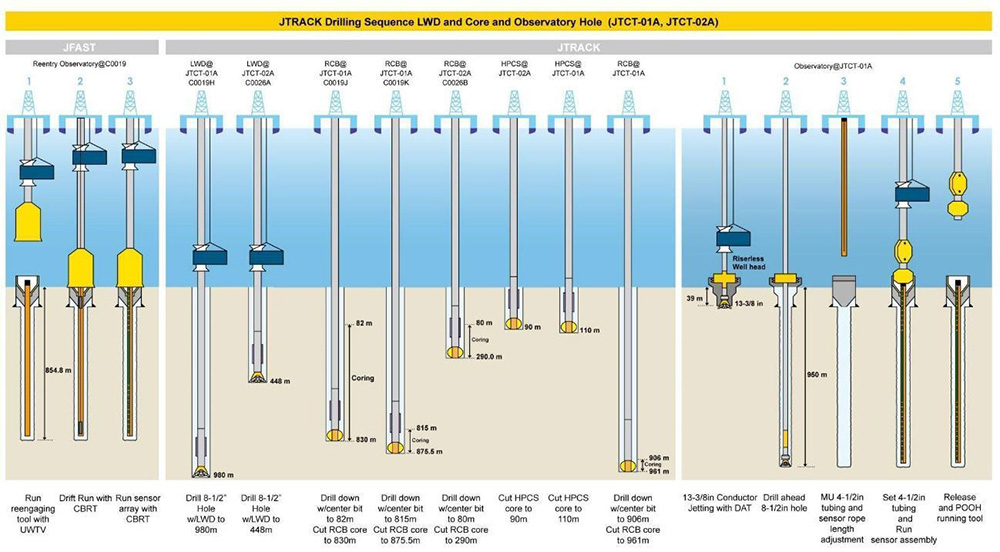
Figure 2: Drilling process
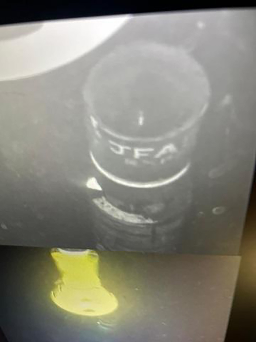
Photo 1: Underwater TV camera image of the thermometer installation in the JFAST borehole on September 12.
For this study
(For IODP and this expedition)
General Affairs Group, Planning and Coordination Department,
Institute for Marine-Earth Exploration and Engineering (MarE3)
For press release