Column [Submarine volcanic eruption in Tonga]
- Similarities between Hunga volcano (Hunga Tonga-Hunga Ha’apai) in Tonga and Nishinoshima volcano in Japan -
TAMURA Yoshihiko, Principal Researcher,
Research Institute for Marine Geodynamics (IMG)
A large-scale eruption occurred at Hunga Volcano (Hunga Tonga-Hunga Ha’apai) on January 15, 2022. As of January 28, the actual state of the eruption and its disaster is becoming apparent since the analyses of the form of volcanic smoke, tsunami, impulse wave, and others due to the eruption are progressing.
On the other hand, this column explains the following from the viewpoint of previous volcanological and petrological studies on Hunga Volcano and the crustal structure based on seismic studies of the surrounding water: (1) Firstly, what type of volcano is the Hunga Volcano, (2) why are magmas generated in subduction zones, and (3) what type of magma was it emitting?
The similarities between Hunga and Nishinoshima volcanoes
Japanese researchers are unfamiliar with the Hunga Volcano since it is 9,000 km away from Tokyo in the southern hemisphere. However, in reviewing it, the similarities between the Tonga and the Izu-Ogasawara arcs and those between Hunga and Nishinoshima volcanoes become clear. It is interesting, and we also realize that the eruption in Tonga is of interest to everyone, living Japan.
Hunga Volcano is located in the subduction zone, the same as Izu-Oshima, Miyakejima, Nishinoshima, and Fukutoku-Oka-no-Ba volcanoes. Although Japan and Tonga are far away from each other, both are subducted by Pacific Plate. Also, the Hunga Volcano is a submarine volcano which was formed on a thin crust (approximately less than 20 km thick) and that was erupting andesite magmas, similar to Nishinoshima volcano. Although it has not yet been clarified what type of magma was emitted in the last eruption, we think that the Hunga Volcano and its eruptions should be understood as an important, rather than unique, precedent.
Tonga-Kermadec Arc
The Tonga-Kermadec Arc is an oceanic arc. (When an oceanic plate subducts under another oceanic plate, magma is generated on the overlying plate, and a suite of submarine volcanoes are created. Because the line of volcanos created along the trench is not linear but draws an arc shape, it is called an oceanic arc or a volcanic arc. Because a submarine volcano grows into a volcanic island, an oceanic arc becomes a line of submarine volcanos and volcanic islands). It is formed by the subduction of the Pacific Plate from the Tonga-Kermadec Trench to the Indo-Australian Plate and continues for 2,700 km from the North Island of New Zealand to Tonga (Fig.1). The northern and southern parts are called the Tonga Arc and the Kermadec Arc, respectively. The Tonga Trench in the east of the Tonga Arc is the deepest after the Mariana Trench, with the deepest part being 10,800 m.
Since the Tonga-Kermadec Arc has many similarities with the Izu-Ogasawara Arc because both are oceanic arcs, they have been traditionally compared and discussed.
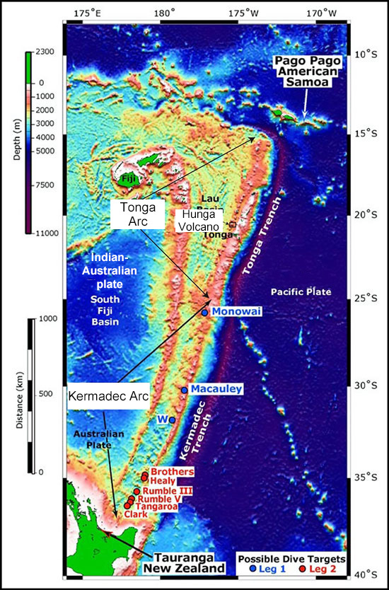
- Fig. 1
- Tonga-Kermadec Arc
The Pacific Plate subducts beneath the Indo-Australian Plate along the Tonga-Kermadec Trench. This plate subduction formed the Tonga-Kermadec Arc.
Figure modified from the following: (https://oceanexplorer.noaa.gov/explorations/05fire/background/plan/media/sw_pac_legs.html).
Crustal structure of the Tonga Arc
Crawford et al. (2003) estimated the crustal structure of the Tonga Arc from east to west, ranging from subducting Pacific Plate, Tonga Trench, Tonga Ridge with volcanos, Lau Basin, to Lau Ridge, by using the seismic wave refraction method (Fig. 2). The figure shows the east-west cross-section of 18 to 19 degrees of south latitude, which is considered to be a typical crustal structure of the Tonga Arc. The Pacific Plate subducts from the east, and the Tonga Ridge and Tonga Volcanic Arc are formed. An ocean basin, which is called the Lau Basin extends behind the Tonga arc. The ocean basin that is formed behind an island arc and to the opposite side of a trench is called a back-arc basin. It has almost the same origin as a mid-ocean ridge. Tongatapu Island, on which the capital of the Kingdom, Tonga Nuku’alofa lies, is located on the east side of the Tonga Ridge (closer to the trench side). Volcanos are formed in a location situated away from a trench to some extent in an almost parallel line with the trench. The place where a volcano appears first is called a volcano front. The volcanic front is located on the west side of Tongatapu Island. The Hunga Volcano is one of volcanoes in the Tonga Arc volcano front.
Looking at the positional relation between the inhabited island and the volcano front for the Izu-Ogasawara Arc, it is the same as that of Nishinoshima, which is located in the volcano front, and Chichijima Island, which is located closer to the trench side. While Nishinoshima is located 130 km to the west of Chichijima Island, the Hunga Volcano is located only 65 km to the north of Tongatapu Island. On the other hand, Chichijima Island is further complicated in terms of its crustal structure. The crustal structure of Chichijima Island, which is a forearc oceanic crust structure formed in the earliest time of the Izu-Ogasawara Arc formation (approximately 50,000,000 years ago), is different from that of Nishinoshima with the middle crust of the volcano front (Kodaira et al., 2010).
Crawford et al. (2003) stated that the Tonga Arc also had the same andesitic middle crust (a layer of andesitic crust with low seismic velocities) as the Izu-Ogasawara Arc (Fig. 2). It has been clarified that such an andesitic crustal structure is continuously seen under the volcanic front of the Izu-Ogasawara Arc (Kodaira et al., 2007), which is the basis for the argument that continents have been formed in an oceanic arc, together with the fact that the average composition of the continental crust is andesitic. There is a correlation between the crustal thickness and the composition of erupting magmas (lavas) on the crust for oceanic arcs, and andesite magmas erupt in oceanic arcs with thin crust. Therefore, a new hypothesis that “continents are created in the sea” is proposed (Tamura et al., 2016, JAMSTEC September 27, 2016 press release, “Proposing a new theory that continents were born from the sea - does the Nishinoshima Island eruption reproduce continent creation?”).
Interestingly, Contreras-Reyes et al. (2011) estimated the crust of the Tonga Arc has about 20 km in thickness. The crust thickness of 20 km is almost the same as that of Nishinoshima Island. The ‘genesis of continents’ hypothesis is verified by using the lava compositions erupted on the submarine flank of Nishinoshima Island (Tamura et al., 2018, JAMSTEC November 12, 2018 press release, “Verifying that the Nishinoshima Island eruption reproduced continent creation”). The same argument can also be applicable to the Hunga Volcano. This is because the Hunga Volcano has experienced andesite magma eruptions but there is no evidence of basalt magma eruptions (Brenna et al., 2022, in press). Since a volcano erupting on the ground has lost information about its deep magma source, it is essential to collect quenched lava flows from the seafloor. We want to use lava flows and pyroclastic materials erupting onto the seafloor around Hunga Volcano to clarify the origin of magmas by carrying out the same analyses as those of Nishinoshima Island.
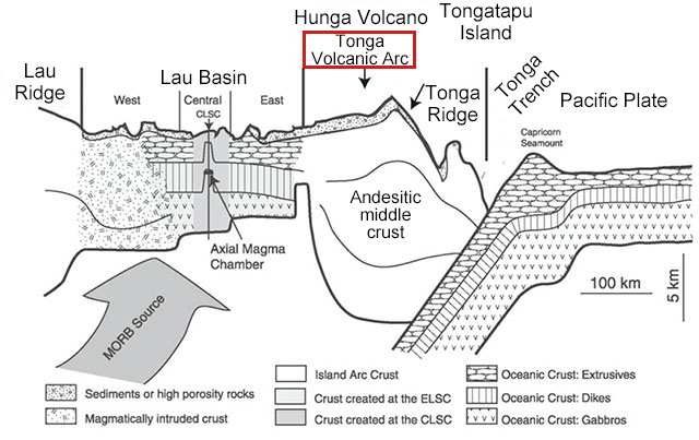
- Fig. 2
- Crustal structure of the Tonga Arc.
Volcano front is located on the Tonga Ridge, and the Hunga Volcano is one of submarine volcanos in the volcano front. Tongatapu Island is on the trench side of the volcano front. Modification of the figure by Crawford et al. (2003).
Hunga Volcano (Hunga Tonga-Hunga Ha’apai)
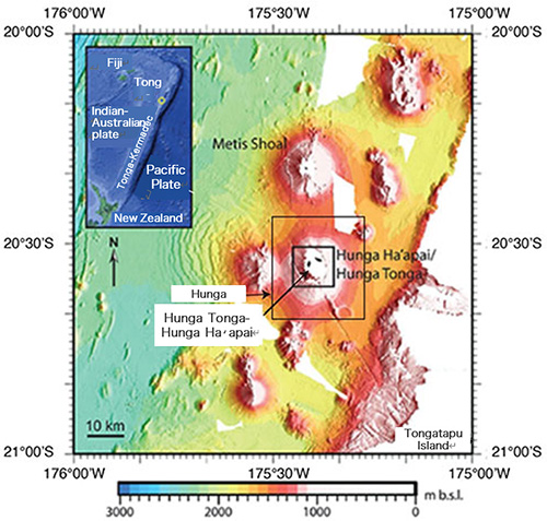
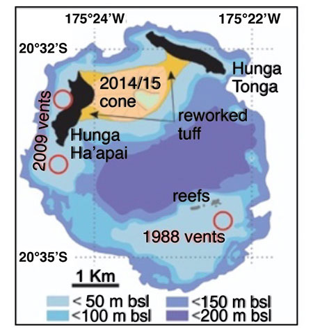
The Hunga Volcano, one of the submarine volcanos in the Tonga Arc, is a huge submarine volcano with a bottom diameter of 30 km and that grows from a water depth of 1,700 m (Fig. 3). A submarine caldera (subsidence topography) with a long diameter of approximately 3 km was formed at the summit of the Hunga Volcano. Hunga Tonga and Hunga Ha’apai Islands were volcanic islands formed on the edge of the caldera (on the north side and northwest side) (Fig. 4).
An eruption occurred from the seabed on the south side of the caldera in 1988, and an eruption occurred from the waters near Hunga Ha’apai on the west side in 2009. Each island had a length of 2 km and a height of 114 m above sea level in 2013. After an eruption occurred between the two islands in 2014 and 2015, they were connected by volcanic products and redeposited volcanic ash (tombolo) (Fig. 4). Thus, eruptions had previously occurred several times at the summit of the huge Hunga Volcano with a diameter of 4 km.
However, the explosive eruption on January 15, 2022 seems to have submerged most of the islands. The summit may have been blown off by a large eruption and collapsed under the sea-level due to large landslides. Otherwise, a magma reservoir may have been emptied by the eruption of a large amount of volcanic ash, which may have resulted in a new caldera with a diameter of more than 4 km exceeding the previous caldera, and has eliminated the land part. Investigation of topographic evolution by a detailed seafloor mapping and chemical analysis of erupted materials are required to clarify this eruption's actual state.
While intermittent Strombolian eruptions (relatively small eruptions erupting magma with low viscosity and propelling volcanic projectiles and others into the air) had continued on Nishinoshima Island since 2013, basalt magma that had never occurred before spewed forth from the sudden explosive eruption in 2020 (Maeno et al., 2021, JAMSTEC topics: column August 6, 2020, Observing closely future activities of Nishinoshima Island).
This Hunga Volcano eruption holds many mysteries, including the following: “What type of magma caused it?”, “Was a caldera formed?”, and “Why was it so explosive?” Both the Hunga Volcano and Nishinoshima Island are submarine volcanos of andesite, and basalt magma was involved in the explosive eruption on Nishinoshima Island in 2020. These facts suggest that not only andesite magma, but also new basalt magma may have been involved in this explosive eruption of the Hunga Volcano. Solving these mysteries will provide Nishinoshima Island, also a submarine volcano, with direct suggestions for future submarine volcano studies and investigations of the origins of the continents on the Earth.
Since Tonga is 9,000 km away from Japan, there are various obstacles, including expenses, to utilize a ship and a remotely operated vehicle of JAMSTEC. However, considering the roles that studies of Tonga volcanos will play in future Japanese volcano studies and future volcanic disaster preventions/mitigations for the Izu-Ogasawara Arc, it is significant to study the sea area independently.