


Hard workMay 5, 2012
Last week we made headlines around the world when Chikyu’s drill string reached a new record length for ocean scientific drilling: a total of 7768.5 m measured from the rig floor (7740 m below sea level). OK, maybe “headlines” is stretching it but within the scientific drilling community, this was big news! Credit for this record goes to the hard work and ingenuity of the engineers, drillers and crew of D/V Chikyu. Here in the scientists’ library, we were celebrating their achievement by getting to work on the Logging-While-Drilling data that were collected. This was the first look at the fault we came to study, and the first indication of what kind of rocks we would encounter, and the first test of borehole stability in this deep environment.
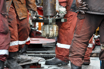
New drill bit is assembled to the drill pipe on the rig floor. Photo by Tadashi Yoshizawa.
We poured over the data as it came in ? low resolution in real-time, and after the hole was complete and the instruments were back on board. The logging engineers downloaded the data from the instrument memory ? detailed images of the borehole walls, and long wiggly lines which showed the sediment and rock properties. For me, a field geologist, it was my first time seeing this type of data. I tried to imagine what the rocks would look like in an outcrop, or feel like in my hand, and what small features I could see with my hand lens if I had a sample to examine. There were some clues which the logging scientists helped me learn how to read in the data: fracture patterns, the subtle traces of sedimentary bedding. Most exciting were the points in the data which showed big changes in rock type down the hole: the transition from silica-rich sediments to a layer of clay, for example. I hope soon we will recover some core and I will get to find out if my imagined samples are anything like the real thing.
One of the old assumptions we are testing on this mission is whether the deep water sediments that make up the hanging wall of a subduction thrust fault are very soft and weak (and just get pushed around by earthquake slip in the stronger rocks at deeper depths in the fault) or whether they are strong enough to release some elastic energy themselves. We won’t be able to answer this until we have the sediment samples in hand, sometime in a week or two. But in case you’re wondering, this is what 856m of drilling will do to a new drill bit:
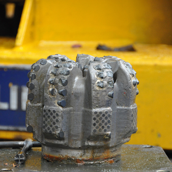
After the drilling, damage to the microdiamond-bearing drill teeth.
This probably happened when drilling through hard chert! Photo by Tadashi Yoshizawa.
Why are there field geologists on a drilling vessel?April 16, 2012
このレポートは、Scientific American誌ブログにも掲載されています。
Greetings from Drilling Vessel (D/V) Chikyu, currently maintaining position about 220 km east of Sendai, directly over the Japan Trench and above the fault area of the March 11, 2011 Mw9.0 earthquake. We are on International Ocean Drilling Program (IODP) Expedition 343: the Japan Trench Fast Drilling Project (JFAST). Our goal here is to drill into the seafloor and penetrate the earthquake rupture zone at around 1-km depth.
We will make direct observations and collect samples of the fault zone below the seafloor, in order to understand the very unique features of the earthquake last year, to clarify how the rupture propagated all the way to the trench and generated such a great tsunami, and to learn more about the general physical properties that control earthquake rupture which we can apply to other areas.
The speed with which this expedition has been executed by international cooperation is unprecedented (it usually takes ~3 years to plan a research cruise), because some of the phenomena we are trying to observe, which record the details of the earthquake slip process, are literally fading away into the sea. I’ll discuss these in a future post. I’ll start with something a little more concrete: the rock samples we hope to collect by drilling directly into the plate boundary fault which generated the earthquake.
A little background about the geology of earthquakes
In the shallow parts of the Earth’s crust, rocks are strong. As you look deeper in the crust, temperature increases, and when it reaches about 350-450°C, most rocks soften and start to gently flow. So, earthquakes and other types of brittle failure occur most often at shallower levels. At the surface, stress is too low to initiate earthquakes, but as you go down, the stress from the overburden load and from tectonic plate motions both increase.
These two constraints are the boundaries of the “seismogenic zone” ? where earthquakes nucleate and where the most earthquake energy is usually released. The actual depth limits on the seismogenic zone vary from plate to plate and fault to fault ? depending on the specific rock type and temperature profile of the crust, and the local conditions of stress and rate of plate motion.
In my usual research, I go around the world looking for rocks from ancient faults, specifically, inactive faults that have been uplifted 10 or 20 km, the overburden eroded away, to expose the inner workings of the seismogenic zone. I go to the places where I can see the most rocks: deserts, where there is little soil or vegetation cover, and in wetter climates, I seek out ancient faults in glaciated or uplifted terranes where erosion has been rapid enough to expose the rock. Here’s one of the places I have worked, a cliff on the beach on Kodiak Island, Alaska:
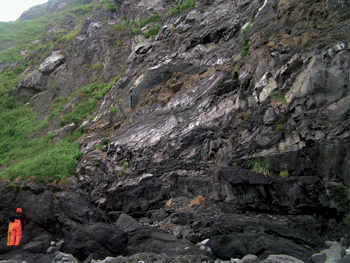
That’s geologist Francesca Meneghini from Pisa, Italy, wearing the bright orange rain gear. Francesca and I were in Alaska (with Casey Moore, another JFAST geologist) to map the sandstones, shales and volcanic rock that were deposited in an ocean trench 60 million years ago, similar to the Japan Trench today.
These sediments were sheared during subduction in the boundary between two tectonic plates. This thrust fault shook with great earthquakes and produced tsunamis. And now, 60 million years later, uplift and erosion has exposed the core of the former earthquake generation zone in these cliffs where we can see it. As field geologists, we have the great opportunity to observe the inner workings of faults, on the scales that are really important; most earthquakes come from thin (1-10 cm) faults within zones about 10-30 m wide. It’s really like we are visiting earthquakes where they live.
But ? we also have the disadvantage of studying faults so ancient that we have no idea exactly how big the earthquakes were, or how frequent ? it can be hard to link our observations of earthquakes that occurred millions of years ago to the real-time events on modern faults that affect people’s lives.
The JFAST Expedition has the opposite situation: the team sailing on D/V Chikyu right now are very aware of the human experience in the earthquake and tsunami of last year. The vessel herself survived the tsunami in the harbor at Hachinohe, north of Sendai, and many of our colleagues on board experienced the earthquake and tsunami first-hand.
Investigating the geologic processes takes on a very personal aspect, and the desire to understand these events is more than just academic. In this case, we know the exact timing of events and the scale of fault slip, but the fault lies 8 km under the ocean’s surface. The water at our chosen drill site is 6910 m deep, and we think the fault is a bit less than 1 km below the sea floor. This site was chosen to stay within the drilling capabilities of D/V Chikyu ? if we went farther west, the water would be shallower but the fault would lie deeper below the sea floor, and east, the water would be too deep.
If successful, we will complete the deepest hole ever drilled in comparable ocean depths. This is an extraordinary effort to gain access to an active fault. Other earthquakes have been the focus of subsurface investigations, with rapid response drilling in Japan after the Kobe earthquake (1995), and in China after the M7.9 Wenchuan earthquake (2008). These efforts have revealed a lot of new information (and new questions) about the inner workings of the earthquake cycle, but these faults are quite different than the subduction thrust faults that are responsible for the greatest earthquakes and most of the tsunamis.
Drilling is the only way to see this fault, but this kind of view presents its own challenges
If we are successful in recovering a core sample from our drilling efforts, we will get a 6.5-cm diameter core, up to 400 m in total length, and somewhere in this long noodle of mud and rock we may have a tiny slice of the March 11, 2011 earthquake fault.

This second picture shows our geological map, in color, of the sea cliff in the first photo. Subduction faults are complicated mixtures of rock. The red dashed line shows the thin faults where earthquakes struck 60 million years ago. To give you an idea of the challenges we will face on Chikyu, I’ve made up two different hypothetical boreholes to show you what it might be like if we were studying this ancient fault zone in a thin drill core. Next to each “core section” you can see the layers of rock, cut by faults, which a geologist might read and record from the core.
We will only have one core of rock, one tiny window, into what we know will be a complicated zone. We won’t know whether the hole we’ve drilled penetrated a more complex location, like core 1, or a simple section, like core 2. We may see only one major fault, as in core 2, or we may see multiple faults, preserving a record of additional, older earthquakes. In either case, we will be able to answer some important questions: How thick is the zone that slips during an earthquake? How hot does it get? And what characteristics do these rocks have that make them especially prone to extreme earthquake slip?
The field geologists on board will be leveraging our insights from field studies of exposed faults to try to make sense of our core sample, and the measurements we make of the borehole walls while we are drilling. Unlike my studies of ancient fault outcrops, this time we will also measure the heat and chemistry in the fault that only last a few years after the quake. So if we find a record of many old earthquakes in our core, and I hope we do, we will be able to use this information to pinpoint the specific one that slipped on March 11, 2011.


