


A Glimpse of What's Below: Logging While DrillingApril 30, 2012
このレポートは、Scientific American誌ブログに掲載されています。
Greetings from Drilling Vessel Chikyu! We are floating precisely at N37’ 57” E143’54”. I know we are precisely there because this unusual ship with its five working thrusters can maintain position to within meters. The sixth thruster was damaged on March 11, 2011 when D/V Chikyu, with full crew and elementary students aboard, when the tsunami caused by the Tohoku earthquake arrived at the port of Hachinohe. Thanks to quick thinking by the captain and crew, no one onboard was injured and the children were returned safely to land.
This memory is fresh in the minds of the crew and science party aboard this ship, many of whom experienced the events of March 11. The earthquake was larger than expected for this part of the coast, and the seismological community has been very active in the past 13 months revisiting everything we used to know about earthquake hazard. What’s more, the tsunami generated by this earthquake was bigger than expected ? as you have seen in the photos and videos of waves topping the seawalls in towns along the Tohoku coast. For its size, this earthquake was alarmingly effective at creating a tsunami wave.
Why? What was so special about this earthquake? Clues started emerging in the days and weeks after March 11. Japan has the most detailed network of seismometers and GPS stations, all collecting data in real time, of any country in the world. The seismometers recorded the seismic waves generated by the earthquake, and the GPS stations tracked the motion of the Japanese islands toward the deep ocean trench. Data were collected from sensors on the ocean bottom that recorded the changes in water depth related to ground deformation, ships studied the bathymetry, which showed the horizontal displacement of the edge of the North American plate toward the west.

LWD paradise!April 28, 2012
Data from the record-breaking JFAST hole turned from a trickle into an avalanche last night. The logging while drilling (LWD) tool measures a variety of physical properties of the rock penetrated by the drill bit. During the drilling operation, measurements are sent back up the drill string to the ship via a pressure-pulse in the drilling mud. We were receiving these measurements throughout the drilling, watching the monitor for a new point every 2 minutes. The communication system transfers data at a much slower rate than data are collected, so the majority of the measurements is stored locally on memory inside the tool itself. After the decision was taken to stop penetrating further into the subsurface, the tool was withdrawn and arrived on deck yesterday.
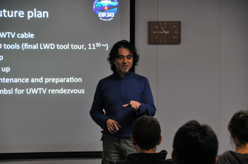
The new data were immediately downloaded from the memory inside the tool and the logging staff scientists and contractors got to work processing to make them available to the science team. We now have huge print outs of the entire section penetrated by the LWD hole, as well as the digital versions of the data. It’s like a treasure trove of information suddenly arrived on deck! Everyone in the science team is fascinated to see what the results show: the resistivity measurements and images and the gamma ray measurements give information on the different rock types, various deformation features, and the stability of the hole itself. But the big question on everyone’s mind is ‘where is the earthquake fault?’ The logging while drilling scientists are in overdrive getting the data processed, and interpretations developed. Several scenarios are possible based on the LWD data so we might need the long-term observatory data and the core observations to confirm the location of the fault. The LWD tool has given us the first glimpse into the subsurface and the plate boundary interface.
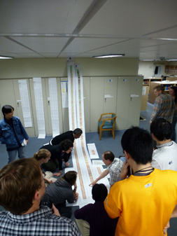
The science team devours the 5m long print out showing the newly available LWD data.

Record StartApril 24, 2012
Three weeks into the expedition and we were still waiting for the drilling to begin. There had been several false starts during the last two weeks and everyone was getting anxious about the delays. April 22 was a Sunday so there were fewer work activities as the science party relaxed on the weekend. It was also my birthday. I was completely surprised when the scheduled afternoon coffee break turned out to be a birthday party for me.
A lot of effort had gone into decorating the lounge for the party. I’m sure people had more fun creating all the elaborate designs, than the actual party itself. That’s fine with me since I favor any reason to have some fun. Among the decorations, there was a megathrust/sea cucumber/methane molecule/catfish sculpture, a big rainbow poster signed by everyone, leis made of paper flowers, and lots of balloons with written messages. I especially liked the balloon which promised a birthday present of ‘Data’.
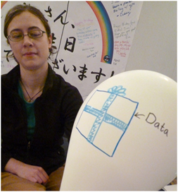
Christine Regalla with the ‘Data’ balloon from the birthday party.
The ship’s cook provided a cake and Louise Anderson told me to make a secret wish and blow out the candles (3 lighters held by Sanny Saito, Virginia Toy and Nobu Eguchi). Although, everybody knew that my wish was for the success of the expedition and especially to start collecting some data.
Data !
Needless to say, I am writing this blog because the birthday wish came true. If it hadn’t come true, I would be talking about albatrosses and poetry. A little before midnight we got the word that the drill bit was close to the ocean floor and we were ready to ‘spud in’ (another message on a party balloon).
One responsibility of the co-chiefs is to verify that the ship is in the correct location to start the borehole. Fred Chester and I went to the control room on the rig floor to give the approval for drilling, not that we really knew where in the ocean we were, other than having some GPS coordinates from the bridge.
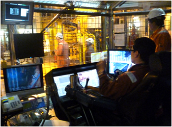
Driller’s house where operations are controlled on the rig floor.
The start of drilling was rather anticlimactic and quite slow over the first few tens of meters. Although, it was a relief when we received confirmation that logging data were being received from tools on the drill string. It is impressive that signals from the instruments near the drill bit can be sent through 7 kilometers of mud and water by acoustic pulses. This telemetry system had never been used before over such a long distance.
We were collecting data! A long three weeks of mostly waiting onboard the ship and an even longer year’s work by so many people in preparation for the JFAST project, and now the first borehole was really started and we were on out way to the fault !
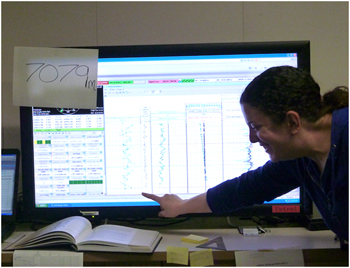
Monica Wolfson in front of monitor which displays logging data. 7079 m is the record breaking depth, as recorded at the rig floor, which 28.5 m above the sea level.
New World Record
Not only did we start collecting data for Expedition 343, we also set a new record in the process. Around 8:30 the next morning, Monica Wolfson, a morning shift watchdog, came by to say that the drilling was approaching the eagerly anticipated depth of 7049.5 meters below the sea surface. This depth represented the previous greatest total depth below sea level for any scientific ocean drilling project, and we were about to break that record. Colored data points appeared on the logging monitor, indicating that the drill bit was passing 7049.5 meters. Jim Sample popped open a precious can of Coke and carefully portioned it out into 15 small paper cups for a toast to the historic occasion.
Drilling continued through the night to a depth of 7308 meters below the sea surface (424 meters below the seafloor with a water depth of 6883.54 meters). Previously, the deepest penetration below the sea surface, as mentioned above, was 7049.5 meters during Deep Sea Drilling Program (DSDP) Leg 60 to the Marianas Trench in 1978. The DSDP borehole was drilled 15.5 meters below the seafloor in a water depth of 7034 meters.
From a birthday party to a wished for data collection, and from a long anticipated drilling start to a new world record, it was a couple of exciting days on the D/V Chikyu.
Breaking the depth record for scientific drilling.

Why are there field geologists on a drilling vessel?April 16, 2012
このレポートは、Scientific American誌ブログにも掲載されています。
Greetings from Drilling Vessel (D/V) Chikyu, currently maintaining position about 220 km east of Sendai, directly over the Japan Trench and above the fault area of the March 11, 2011 Mw9.0 earthquake. We are on International Ocean Drilling Program (IODP) Expedition 343: the Japan Trench Fast Drilling Project (JFAST). Our goal here is to drill into the seafloor and penetrate the earthquake rupture zone at around 1-km depth.
We will make direct observations and collect samples of the fault zone below the seafloor, in order to understand the very unique features of the earthquake last year, to clarify how the rupture propagated all the way to the trench and generated such a great tsunami, and to learn more about the general physical properties that control earthquake rupture which we can apply to other areas.
The speed with which this expedition has been executed by international cooperation is unprecedented (it usually takes ~3 years to plan a research cruise), because some of the phenomena we are trying to observe, which record the details of the earthquake slip process, are literally fading away into the sea. I’ll discuss these in a future post. I’ll start with something a little more concrete: the rock samples we hope to collect by drilling directly into the plate boundary fault which generated the earthquake.
A little background about the geology of earthquakes
In the shallow parts of the Earth’s crust, rocks are strong. As you look deeper in the crust, temperature increases, and when it reaches about 350-450°C, most rocks soften and start to gently flow. So, earthquakes and other types of brittle failure occur most often at shallower levels. At the surface, stress is too low to initiate earthquakes, but as you go down, the stress from the overburden load and from tectonic plate motions both increase.
These two constraints are the boundaries of the “seismogenic zone” ? where earthquakes nucleate and where the most earthquake energy is usually released. The actual depth limits on the seismogenic zone vary from plate to plate and fault to fault ? depending on the specific rock type and temperature profile of the crust, and the local conditions of stress and rate of plate motion.
In my usual research, I go around the world looking for rocks from ancient faults, specifically, inactive faults that have been uplifted 10 or 20 km, the overburden eroded away, to expose the inner workings of the seismogenic zone. I go to the places where I can see the most rocks: deserts, where there is little soil or vegetation cover, and in wetter climates, I seek out ancient faults in glaciated or uplifted terranes where erosion has been rapid enough to expose the rock. Here’s one of the places I have worked, a cliff on the beach on Kodiak Island, Alaska:
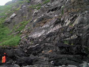
That’s geologist Francesca Meneghini from Pisa, Italy, wearing the bright orange rain gear. Francesca and I were in Alaska (with Casey Moore, another JFAST geologist) to map the sandstones, shales and volcanic rock that were deposited in an ocean trench 60 million years ago, similar to the Japan Trench today.
These sediments were sheared during subduction in the boundary between two tectonic plates. This thrust fault shook with great earthquakes and produced tsunamis. And now, 60 million years later, uplift and erosion has exposed the core of the former earthquake generation zone in these cliffs where we can see it. As field geologists, we have the great opportunity to observe the inner workings of faults, on the scales that are really important; most earthquakes come from thin (1-10 cm) faults within zones about 10-30 m wide. It’s really like we are visiting earthquakes where they live.
But ? we also have the disadvantage of studying faults so ancient that we have no idea exactly how big the earthquakes were, or how frequent ? it can be hard to link our observations of earthquakes that occurred millions of years ago to the real-time events on modern faults that affect people’s lives.
The JFAST Expedition has the opposite situation: the team sailing on D/V Chikyu right now are very aware of the human experience in the earthquake and tsunami of last year. The vessel herself survived the tsunami in the harbor at Hachinohe, north of Sendai, and many of our colleagues on board experienced the earthquake and tsunami first-hand.
Investigating the geologic processes takes on a very personal aspect, and the desire to understand these events is more than just academic. In this case, we know the exact timing of events and the scale of fault slip, but the fault lies 8 km under the ocean’s surface. The water at our chosen drill site is 6910 m deep, and we think the fault is a bit less than 1 km below the sea floor. This site was chosen to stay within the drilling capabilities of D/V Chikyu ? if we went farther west, the water would be shallower but the fault would lie deeper below the sea floor, and east, the water would be too deep.
If successful, we will complete the deepest hole ever drilled in comparable ocean depths. This is an extraordinary effort to gain access to an active fault. Other earthquakes have been the focus of subsurface investigations, with rapid response drilling in Japan after the Kobe earthquake (1995), and in China after the M7.9 Wenchuan earthquake (2008). These efforts have revealed a lot of new information (and new questions) about the inner workings of the earthquake cycle, but these faults are quite different than the subduction thrust faults that are responsible for the greatest earthquakes and most of the tsunamis.
Drilling is the only way to see this fault, but this kind of view presents its own challenges
If we are successful in recovering a core sample from our drilling efforts, we will get a 6.5-cm diameter core, up to 400 m in total length, and somewhere in this long noodle of mud and rock we may have a tiny slice of the March 11, 2011 earthquake fault.

This second picture shows our geological map, in color, of the sea cliff in the first photo. Subduction faults are complicated mixtures of rock. The red dashed line shows the thin faults where earthquakes struck 60 million years ago. To give you an idea of the challenges we will face on Chikyu, I’ve made up two different hypothetical boreholes to show you what it might be like if we were studying this ancient fault zone in a thin drill core. Next to each “core section” you can see the layers of rock, cut by faults, which a geologist might read and record from the core.
We will only have one core of rock, one tiny window, into what we know will be a complicated zone. We won’t know whether the hole we’ve drilled penetrated a more complex location, like core 1, or a simple section, like core 2. We may see only one major fault, as in core 2, or we may see multiple faults, preserving a record of additional, older earthquakes. In either case, we will be able to answer some important questions: How thick is the zone that slips during an earthquake? How hot does it get? And what characteristics do these rocks have that make them especially prone to extreme earthquake slip?
The field geologists on board will be leveraging our insights from field studies of exposed faults to try to make sense of our core sample, and the measurements we make of the borehole walls while we are drilling. Unlike my studies of ancient fault outcrops, this time we will also measure the heat and chemistry in the fault that only last a few years after the quake. So if we find a record of many old earthquakes in our core, and I hope we do, we will be able to use this information to pinpoint the specific one that slipped on March 11, 2011.

この2週間、いろいろありましたApril 16, 2012
出航からこの2週間、船上には嵐が来たり、機器の調整が続いたりといろいろありましたが、今日の夕方(4/13 金曜日!)やっと最初の掘削工程となる、20インチケーシングの海中への降下が始まりました。
20インチケーシングパイプを海底まで運ぶランニングツール
ふぅ、やっとスタートラインについた!という心境です。
荒天に揺られた数日、その後のこう着状態。乗船している研究者の顔も日増しに厳しくなって来ていた、このところでした。
ドリルフロアではエンジニアやドリラーの人々は必死に働いています。もちろん研究者達はその働きをリスペクトしています。もちろんリスペクトしていますが、研究チームのサポートを統括する私としては、はやくデータが見たい、サンプルを採りたい!と気がはやる研究者たちの心の中で、なかなか簡単に物事が進まない現実に対する欲求不満がつのってくるのが肌で感じられるこのところでした。
風速40m/s近い嵐もやってきたりと。
毎朝の全体研究会議でオペレーションの進捗状況を報告するのが、日に日に辛くなる毎日。でも私が笑顔を忘れたらダメなんだと、なんとかみんなを笑わせて・・・と四苦八苦。
もちろん、この先にもいろいろな事が待ち構えているはずです。ひとつひとつそれを越えてゴールを目指す、まぁそれが航海の醍醐味かな?と言えるのも、とりあえずスタートラインに立てたからですね。
毎朝のジョークを考えるのが日課

Frictional HeatApril 13, 2012
Chikyu crew testing out frictional heating (courtesy of Charna)
One of the major objectives of JFAST is the measurement of temperature in the fault zone. Why is this important - well, rapidly rub your hands together like the some of the Chikyu crew are doing in the above picture. Your hands start to get warm due to friction. The slip that occurred on the fault during the Tohoku earthquake would have produced a lot of frictional heat. By measuring how the temperature of the fault zone changes with time scientists can estimate the frictional heat produced when the fault slipped. This can then be used to infer information about frictional stress on the fault.

Short update from onboard ChikyuApril 13, 2012
Chikyu has been on site of our proposed boreholes for a few days now, but we haven’t yet begun drilling because various pieces of gear are playing up ? I don’t think this is atypical on drilling operations and am happy to bide my time and hope it all works out and we begin to core soon.
In the meantime, through variable weather, I’ve been learning my way around the ship, and learning about ship-board life.
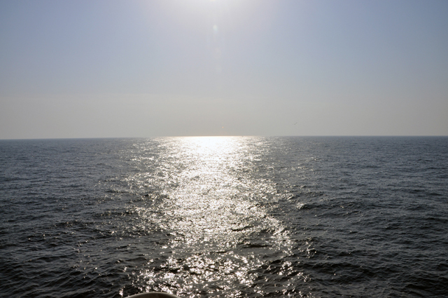
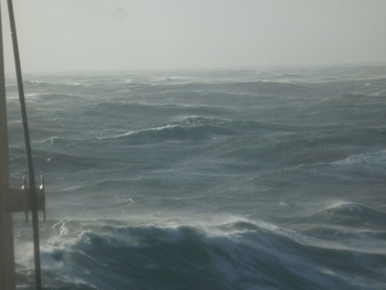
The sun is reflected off a calmer ocean than today! Notice the slight curve in the horizon?
Photo by Nobu Eguchi.
One thing that keeps striking me is the apparent endlessness of the ocean we are sitting upon. I’ve been really enjoying standing on deck observing it. Every time I go up there, the sea state seems to have changed. Today it is particularly ‘interesting’ since there are two major conflicting sets of waves that are interacting. One large set coming from the east appear as ridges stretching across the whole ocean. A second set are less continuous, but when they intersect the large set in the right way, they form breaking waves and foaming masses of white water. When these hit the ship, we feel massive shudders, much like earthquake shaking. This just seems really odd in light of the two very large (Mw 8.2 and 8.6) strike slip earthquakes felt off Sumatra last night. Jim Mori (Co-chief scientist of this expedition) just gave an interesting presentation on those earthquakes, and we discussed whether similar events could be felt in this region some time after the mega-thrust earthquake.
There have been so many great scientific discussions onboard over the last few days, about a wide variety of research the Science Party members are presently engaged in that is relevant to understanding this particular subduction thrust fault. I think we are all intellectually primed and really ready to start coring as soon as we can!
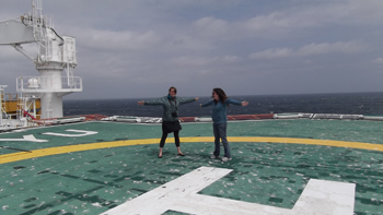
Christie Rowe (Canada) and Monica Wolfson (USA) try to illustrate the extent of the endless ocean from the relative safety of the helicopter deck.

Earning My Sea LegsApril 13, 2012
Today marks the end of my journey on Chikyu. As a land lover, I wasn’t sure what to expect when I boarded (or even if the motion sickness medicine would work). I leave now surprised at how fast the time has passed and amazed at the brilliant scientists and crew working to make the expedition a success.
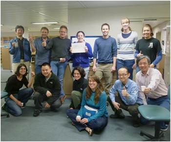
I was on Chikyu to assist with expedition-related education and outreach activities. Upon arriving, we were immediately given a crash course about life on a ship ? from meal times to evacuation procedures. We were assigned rooms and safety gear, and laboratory training started soon after. In no time, the science party ? composed of scientists from 10 countries ? started getting to know each other and sharing their excitement and thoughts about the work ahead.
The science party is only part of the Chikyu story. The ship operates with an impressive crew of about 150 people that includes everyone from roughnecks on the drill floor to cooks in the galley. The crew has been extremely kind and generous, making everyone feel at home. Dennis keeps us safe, Alex found the perfect safety goggles to fit over my glasses, and Romeo prepares delicious meals. During the typhoon-like storm last week, I was stuck in bed (the meds can only do so much), and to my surprise the crew left fresh towels by my door for when I was feeling vertical again.
I’m a bit disappointed to leave the expedition now, just as the activity is really getting started, but I’m looking forward to hearing more about the rest of the JFAST journey.

Chikyu 剑指钻位,蓄势待发April 9, 2012
2012年4月3日上午8:00(北京时间7:00),“Chikyu(地球号)”在从清水港启航41个小时后到达了IODP 343航次预定的钻探位置。本航次的全名为“Japan Trench Fast Drilling Project (JFAST)”,即“日本海沟快速钻探计划”,目的是在2011年日本东北“3.11”地震海域7000米海底的板块消减带实施钻探,向海底钻进1000米,钻穿引发3.11地震的断层,在钻孔中安装长期温度和压力观测系统,并对钻取的断裂带样品进行各种岩石物理性质的综合研究,探讨板块消减带地震的发生机理。在此次地震中,该消减带区域发生了前所未有的约50米的滑移,并引发了巨大的海啸,造成了世人关注的人员和财产损失。因此,该计划对于深入理解板块消减带的孕震机理,研究如此巨大滑移量的产生机制具有重要的意义。
担当本航次钻探任务的“Chikyu”是目前世界上最为先进的科学钻探船。船体全长210米,宽38米,高130米(其中钻塔高70米),吃水9.2米,总吨位56752吨,海底最深钻探深度可达7000米,能够钻进前所未能的地幔。船上装备了先进的隔水管钻进系统和动态定位系统,可保证在风速23米每秒,浪高4.5米的情况下,船体相对一个固定位置持续地钻进。同时配备了先进的质量分析与质量控制(QA/QC)取样室、微生物学实验室、X射线CT扫描实验室、地球化学实验室、岩心实验室和古地磁实验室以及数据整合系统—J-CORES,各实验室均拥有各领域最为先进的仪器和设备,可满足船上科学家开展研究工作的基本需求。
4月1日下午15:00清水港,Chikyu高耸的钻塔与远处的富士山道别。你找到富士山了吗?
该航次的两位首席科学家分别是日本京都大学防灾研究所的Jim Mori教授和美国德克萨斯A&M大学的Frederick M. Chester教授。他们将领导来自10个国家的28名科学家共同完成这项伟大的科学使命。该航次的Science Party有3名中国科学家,分别是来自日本海洋开发研究机构(JAMSTEC)高知岩心研究所(KOCHI)的林为人(Weiren Lin)研究员、加拿大维多利亚大学(University of Victoria)的研究生孙田昊哲(Tianhaozhe Sun)和中国地震局地球物理研究所(Institute of Geophysics, CEA)的副研究员杨涛(Tao Yang)。
带领我们进入海底世界的“利器”
从一上船,大家就开始为钻探前的各种准备工作忙碌起来,航次Managers为大家介绍船上各种设施,讲解规定,带领大家熟悉船上的各个实验室,认识完成钻探任务的各种装备系统。然而就在大家刚刚进入工作状态的时候,太平洋也为大家的到来“欢呼”起来,自4月3日下午至5日上午,海上台风持续大作,最大风速超过40米每秒,超过13米的巨浪拍打着“Chikyu”,很多人第一次感受到了什么叫“大风大浪”。虽然船上不允许喝酒,大家还是在禁酒三天后集体“醉”了:东倒西歪,不会走直线并且食欲不振。WOW(waiting on weather,噢),这感觉真是not so good。尽管如此,大家仍然克服困难在各自的岗位上兢兢业业地工作,为向7000米海水下的“神秘地带”进军而做最后的准备,这可是世界海洋钻探史上未曾有过的海水深度。对“Chikyu”而言,它是个巨大考验;对船上的科学家而言,是挑战更是机遇。然而,经历过“大风大浪”的人们总是对未来充满信心。
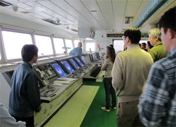
“Chikyu”的“司令部(headquarters)”—Bridge

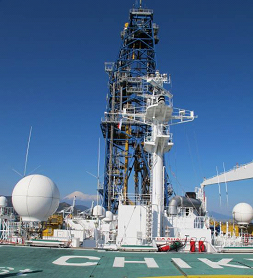
Chikyu: A Truly Impressive Vessel!April 9, 2012
I had been eagerly awaiting the ship tour since the day we set sail, and once the storm passed, the night crew, which includes yours truly, finally got to go. The Chikyu is by far the largest vessel I have ever been on; she’s approximately 210 meters in length and 130 meters in height (from hull to the top of the drilling derrick). Before I left New Hampshire, I was joking with my friends that my biggest fear about the expedition was that I would get lost in the ship on the first day and not found until we come back into port the end of May.
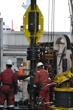
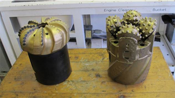
The first stop on the tour was the pipe assembly area, where we had the opportunity to see how the roughnecks, the crew that works on the drill rig, prepares the drill pipe to make the 8-km journey down into the seafloor. Each pipe segment is 9 meters long. It takes a huge winch to pick up each segment of pipe and get it into place. Once two pipe segments are aligned and ready to be connected, a machine called the iron roughneck comes in a screws the pieces together. It is amazing to watch the whole process. Chikyu has been preparing pipe for a couple days now, and they are still going. That is A LOT of pipe.
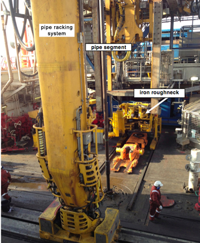
The pipe assembly in action
In the engine control room we met the chief engineer, who told us about some of Chikyu’s operational capabilities. The Chikyu runs off 8 generator engines, which together are capable of generating enough power to run 3000 average-sized homes! There are also 6 thrusters that allow Chikyu to maintain her position in the water to within a few centimeters! There are also four fresh water generators onboard that produce an amazing 200 tons of fresh water a day. With all these capabilities, Chikyu can travel 9000-km or roughly 100-days without needing to resupply.
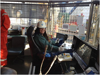
Me sitting in the driller's chair
Chikyu is a truly impressive ship, and I am excited to see the rig floor in action when we start drilling.


