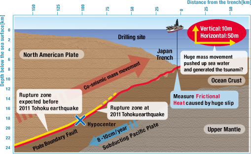


Past thinking was that the plate-boundary fault zone in the region of the accretionary wedge near the trench has weak strength, so that large stress does not accumulate during the time before the earthquake. This means that large slip is not expected when the great subduction earthquakes occur. The 2011 Tohoku earthquake (Magnitude 9.0) off the Pacific coast of Japan has shown this is not always the case. In order to understand how the fault moved with such large displacement in this region, scientists in the wide ranging fields of the Earth and life science, from geology, geochemistry, paleomagnetism, sedimentology, geophysics to microbiology, gather together to come down on what is happening behind devastating Tsunami from the 2011 Tohoku Earthquake.


Clarifying the stress conditions for the shallow portion of the plate-boundary thrust is an important seismological issue for this and all earthquakes. The key to understanding the dynamics of large ruptures is to know the level of dynamic friction on the fault. One of the most direct ways to estimate the fault friction during the earthquake is to measure the residual heat at the fault zone. Theoretical calculations show that measurements need to begin within about 2 years following the earthquake in order to accurately resolve the diminishing temperature signal. Several important time-sensitive measurements are needed for reliable estimates of friction, including the fault temperature, fault zone permeability, and chemical properties of the fluids and rock. Thus the name of the project, JFAST, Expedition 343 of the Integrated Ocean Drilling Program (IODP) requires a particularly rapid mobilization of IODP research facilities to measure the time-dependent properties. Expedition team members get on board the state-of-the-art scientific drilling vessel Chikyu to meet the challenge of drilling to the fault zone of the Tohoku earthquake.


The main goal of the JFAST project is to understand the very large fault slip that occurred on the shallow portion of the subuction zone during the 2011 Tohoku earthquake. This large slip of 30 to 50 meters was the main source of the devastating tsunami that caused so much damage and loss of lives along the northeast coast of Honshu, Japan. In order to understand how the fault moved with such large displacement in this region, the JFAST project has two main objectives. The first is to sample the fault in order to analyze the physical properties of the fault zone. The second is to make temperature measurements to estimate the frictional stress during the earthquake.
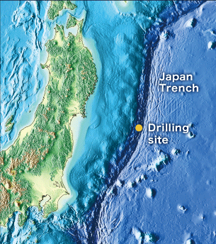

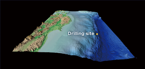
The drilling site is located off Oshika Peninsula, just west of the axis of the Japan Trench. The water depth at the primary drill site is 6,910 meters, and Chikyu will drill as much as 1000 meters below the seafloor to reach the fault zone. In the history of deep sea drilling projects, only one other expedition has successfully drilled at greater water depth, and that was at 7,034 meters in the Mariana Trench in 1978; however, in the Mariana expedition the drilling only sampled to 15.5 meters below the seafloor. The present expedition to the Japan Trench will use about 8,000 meters of drill string and is thus a great scientific, engineering, and record-setting challenge.
The Pacific plates starts to sink at the deep seafloor of the Japan Trench.

The Pacific plate meets and subduct under the North American plate, carrying East Japan, at the Japan Trench East Japan, at the Japan Trench.
The main operations to be completed during the expedition consist of drilling two boreholes at a single location; the first hole is dedicated to collecting downhole geophysical data to determine in situ stress and locate the fault zone, and the second hole is dedicated to retrieving core samples from across the Tohoku earthquake slip surface. Each hole will be completed with an observatory deployment comprised of a suite of temperature and pressure sensors. Observatory data from both boreholes will be retrieved by the JAMSTEC’s Remotely Operated Vehicle (ROV) KAIKO 7000II.