Press Releases
February 5, 2013
JAMSTEC
Start of Real-time Monitoring through submarine cable network by the long-term borehole observatory installed by the Deep Sea Drilling Vessel Chikyu.
The Research Vessel Kaiyo has been deployed on a research cruise by the Japan Agency for Marine-Earth Science and Technology (JAMSTEC: Asahiko Taira, President) since January 18, 2013. The long-term borehole observatory (*1), which was installed by the Deep Sea Drilling Vessel Chikyu beneath the seafloor of the Kumano Basin off the Kii Peninsula in the projected focal region of the Tonankai earthquake, was connected by the Kaiyo to the submarine cable monitoring network for earthquake and tsunami monitoring (*2 DONET) that is being deployed and operated in this ocean area. The data collected by the long-term borehole observatory (strain, temperature, pore-fluid pressure, seismic waves, etc.) were successfully received in real-time through the submarine cable monitoring network; the data quality was verified and it was confirmed that observations could be conducted for scientific research (Figure 1).
This is the world's first real-time data acquisition from seismic and geodetic sensors installed in a borehole beneath the seafloor connected to a submarine cable monitoring network. This will allow investigation of changes beneath the seafloor in crustal strain, temperature, pore-fluid pressure, etc., associated with micro-earthquakes or deformations in the earth's crust and their relationship to the occurrence of large earthquakes. The anticipated findings should contribute to understanding of the mechanisms of earthquakes. In addition, this will allow real-time observation on micro-earthquakes and crustal deformations that would be difficult to monitor with on land or seafloor surface-sited observatories.
Future plans include detailed verification of the quality of the data obtained from the long-term borehole observatory and coordination with organizations monitoring earthquakes in the projected focal region of the Tonankai Earthquake for data distribution.
In addition, it is planned to install a long-term borehole observatory in other locations in the same ocean area that will be connected to the DONET submarine cable monitoring network as well.
*1 The long-term borehole observatory
During the Integrated Ocean Drilling Program (IODP) Expedition 332 (October to December, 2010), a number of sensors (pore-fluid pressure meter, strain meter, broadband seismometer, tilt meter, array thermometers) were installed at approximately 750–940 m depth in a borehole drilled to approximately 1000 m beneath the seafloor off the Kii Peninsula at Site C0002 (ocean depth 1938 m) by the Deep Sea Drilling Vessel Chikyu.
*2 DONET
This is a submarine cable monitoring network installed in the Kumano Basin off the Kii Peninsula in the projected focal region of the Tonankai earthquake; the network funded by the Ministry of Education, Culture, Sports, Science and Technology. The objectives include building a real-time monitoring system targeting the Tonankai earthquake and improvement of earthquake prediction models. The real-time data provided by each monitoring instrument are distributed to the Japan Meteorological Agency and the National Research Institute for Earth Science and Disaster Prevention.
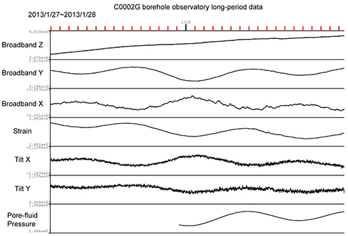
Figure 1 Long-period data (2013/1/27–2013/1/28) from the broadband seismometer (Broadband X,Y,Z), strain meter (Strain), tilt meter (Tilt X,Y) and pore-fluid pressure meter (Pore-fluid pressure) of the long-term borehole observatory connected to the DONET. The effect of tides on crustal deformation is observed.
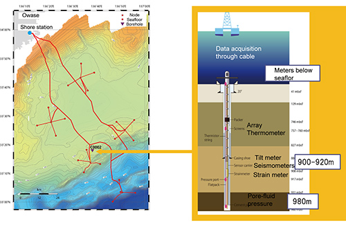
Figure 2 Map of locations of the DONET submarine cable network and long-term borehole observatory and diagram of the layout of sensors in the long-term borehole observatory. The long-term borehole observatory is installed at Site C2 on the map (90 km south of Owase City, ocean depth 1938 m). The overall length of the observatory is approximately 1000 m with the pore-fluid pressure meter located at 980 m depth, the strain meter, broadband seismometer and tilt meter located at 900 to 920 m depth and the array thermometers located at 780 to 830 m depth.
Contacts:
- Japan Agency for Marine-Earth Science and Technology (JAMSTEC)
(For the study) -
Toshihiko Ciba, Manager
Eiichiro Araki, Senior Research Scientist
Earthquake and Tsunami Research Project for Disaster Prevention (DONET)
- (For publication)
-
Kazushige Kikuchi, Director
Planning Department Press Office
Email: press@jamstec.go.jp