Press Releases
February 8, 2013
JAMSTEC
A Scientific Drilling Project by the Deep Sea Drilling Vessel Chikyu Finds Changes in Stress
State in the Largest Displacement Area of the 2011 Tohoku-Oki Earthquake
1. Overview
Weiren Lin (Group Leader) from Kochi Institute for Core Sample Research, Japan Agency for Marine-Earth Science and Technology (JAMSTEC: Asahiko Taira, President) and other researchers have analyzed the geophysical logging data collected by the Integrated Ocean Drilling Program (IODP) Expedition 343 (JFAST: Japan Trench Fast Drilling Project) conducted by Deep Sea Drilling Vessel Chikyu and have determined the in-situ stress state in the frontal prism of the Japan trench subduction zone. On the basis of the horizontal stress orientations and magnitudes estimated from borehole breakouts, and the increase in coseismic displacement during propagation of the rupture to the trench axis, in-situ horizontal stress decreased during the earthquake. The stress change suggests an active slip of the frontal plate-interface consistent with coseismic fault weakening and a nearly total stress drop.
They found that such coseismic stress release is able to occur in the shallow portion of the subduction zone, where previously it had been thought that the stress and energy would not accumulate; consequently seismic slip would not occur. These results are the first to substantiate that energy does accumulate and to explain that a large slip could occur even for a shallow portion of the plate-boundary fault; they will be published on February 8 (US time) in the journal Science.
- Title:
- Stress state in the largest displacement area of the 2011 Tohoku-Oki earthquake
- Authors:
- Weiren Lin, Marianne Conin, J. Casey Moore, Frederick M. Chester, Yasuyuki Nakamura, James J. Mori, Louise Anderson, Emily E. Brodsky, Nobuhisa Eguchi, Expedition 343 scientists
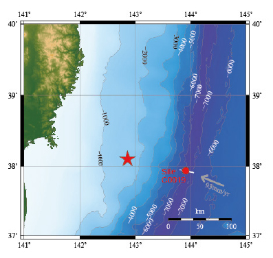
Figure 1 Drilling Site of JFAST
The drilling was conducted about 220 km off the Oshika Peninsula, Miyagi Prefecture, Japan at a site near the trench axis (Site C0019, water depth 6889.5 m). Contours: water depth in meters.
Grey arrow and numbers: Direction of movement of the Pacific Plate and annual speed
Red Star: Epicenter of the Tohoku-Oki earthquake main shock
White Line: Location of Figure 3 crustal structural cross-section
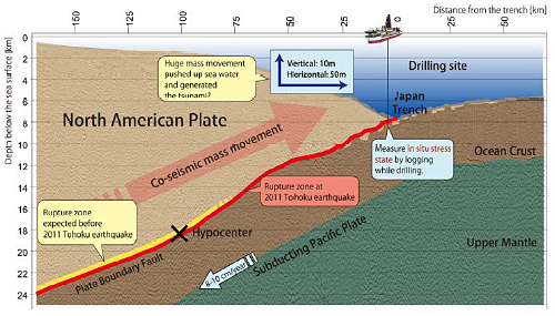
Figure 2 Conceptual diagram of the structure beneath the seafloor at the drilling site
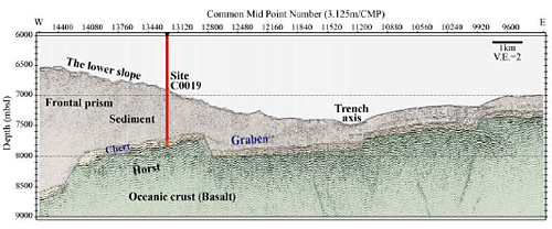
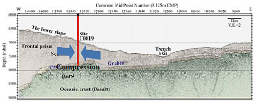
Figure 3 Interpreted seismic line crossing Site C0019. The vertical red line shows the location and approximate drilled depth range.
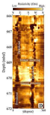
Figure 4 An example of resistivity image of the borehole wall
An actual unwrapped image of the cylindrical borehole wall from 666 to 672 meter below seafloor depth. The black band patterns indicating lower resistivity are the records of breakouts.
[Before the Earthquake]

[After the Earthquake]
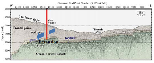
Figure 5 Schematic diagram of the change in the stress state before and after the earthquake
Prior to the earthquake as shown in the upper diagram, the stress state was compression (in the northwest–southeast direction). This changed after the earthquake as shown in the lower diagram to extension (northeast–southwest direction).
Contacts:
- Japan Agency for Marine-Earth Science and Technology (JAMSTEC)
(For the study) -
Weiren LIN, Principal Research Scientist
Kochi Institute for Core Sample Research (KOCHI) Physical Property Research Group
- (For publication)
-
Kazushige Kikuchi, Director
Planning Department Press Office
Email: press@jamstec.go.jp