Press Releases
December 2, 2015
JAMSTEC
3D Laser Scanner Installed in AUV Visualizes Deep-sea Hydrothermal Fields
-A new innovative method for resource exploration-
A research group led by Dr. Shojiro Ishibashi at Marine Technology Development Department of Marine Technology and Engineering Center (MARITEC), the Japan Agency for Marine-Earth Science and Technology (JAMSTEC: Asahiko Taira, President) successfully obtained 3D image data of deep-sea hydrothermal fields in Omurodashi volcano located 20km south of Izu-Oshima. This 3D visualization has been achieved with a 3D laser scanner installed in an autonomous underwater vehicle. The project has been carried out as part of Next-generation Technology for Ocean Resources Exploration of Cross-ministerial Strategic Innovation Promotion Program (SIP)*1 promoted by Cabinet Office.
The 3D laser scanner was installed in an autonomous underwater vehicle (AUV) Otohime, which travelled through Omuro Hole. The scanner vividly captured images of chimneys with a height of a few tens of centimeters and also hydrothermal eruption. Moreover, this visualization technology enabled us, not only to capture objects and events which had been difficult to visualize with exiting acoustic observation systems and camera technologies, but also to obtain geometric information including length, dimensions and volumes.
Subsea laser scanning using AUV is the world's first technology to realize 3D visualization and measurement of deep-sea hydrothermal fields. As a new innovative observation technology, it can offer more accurate and more efficient observations of deep sea, leading to advancement in marine discovery and exploration.
This achievement will be presented at the 2nd symposium of Next-generation Technology for Ocean Resources Exploration of Cross-ministerial Strategic Innovation Promotion Program held in Osaki Bright Core Hall on December 2nd.
*1 Cross-ministerial Strategic Innovation Promotion Program
In 2014, it was newly established with a 5-year plan. The Council for Science, Technology and Innovation (CSTI) takes initiatives in management across government ministries and existing fields, aiming to achieve scientific technology innovation. Among eleven issues set by CSTI, JAMSTEC is responsible for the “Next-generation Technology for Ocean Resources Exploration (Zipangu in the Ocean Plan),” carrying out scientific research on ocean resource genesis and ecosystems with technology development for resource exploration and long-term monitoring system. These technologies will transfer to private sectors.
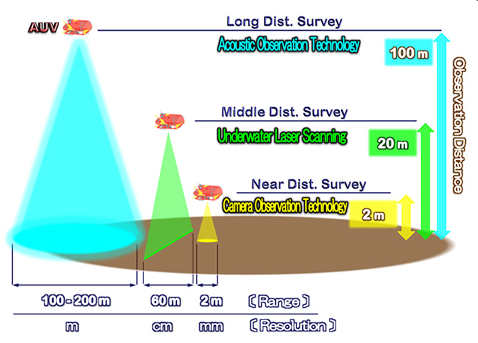
Figure 1: Seafloor observation method
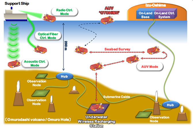
Figure 2: Combined observation system by probe
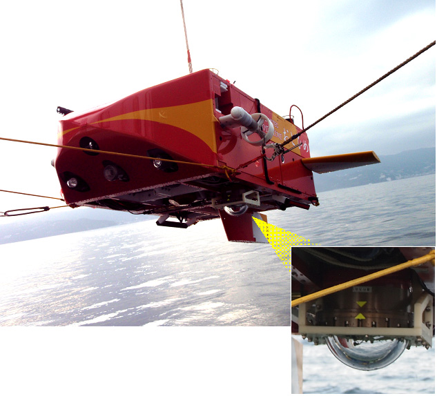
Figure 3: Otohime with 3D laser scanner
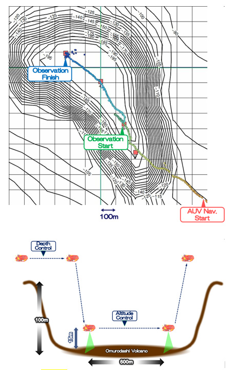
Figure 4: Otohime’s sea route
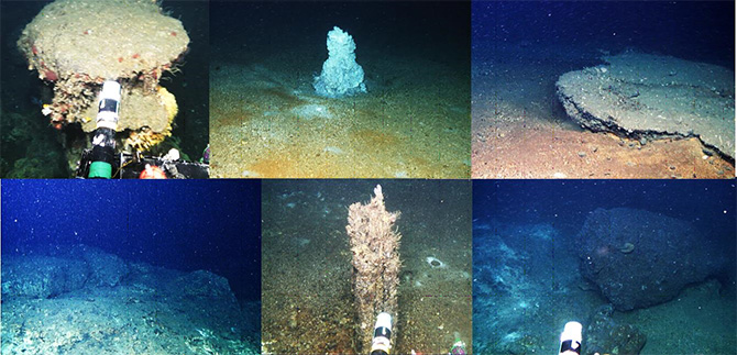
Figure 5: Inside of Omurodashi and Omuro Hole
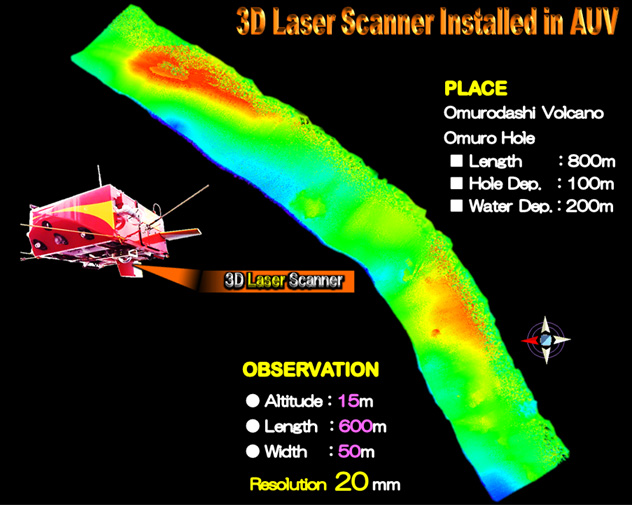
Figure 6: Laser scanned image (Within Omuro Hole /Length: 600m)
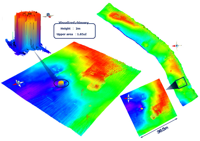
Figure 7: Laser scanned image (chimney/ 2m height)
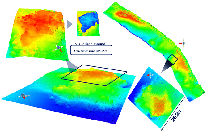
Figure 8: Laser scanned image (Mound / dimensions of 85.65m2)
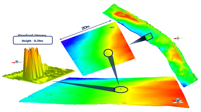
Figure 9: Laser scanned image (chimney / 0.39m height)
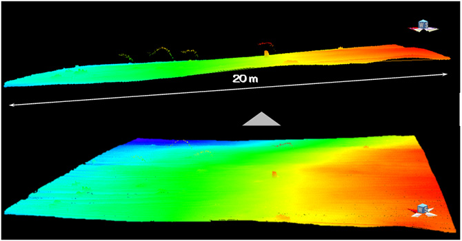
Figure 10: Laser scanned image
(Hydrothermal fields / Enlarged image of Figure 9)
Seen from the different angle from Figure 9, this 3D image, which is almost parallel to the seafloor surface (upper), captures four hydrothermal vent fields.
Contacts:
- (For this study)
-
Shojiro Ishibashi, Senior Technical Scientist, Underwater Vehicle Technology Group, Marine Technology Development Department, Marine Technology and Engineering Center (MARITEC)
- (For press release)
- Hiroyasu Matsui, Manager, Press Division, Public Relations Department