Press Releases
JAMSTEC
New deep-ocean profiling floats reveal
rapid decrease in Antarctic Bottom Water
Overview
Dr. Taiyo Kobayashi of the Research and Development Center for Global Change at the Japan Agency for Marine-Earth Science and Technology (JAMSTEC: Asahiko Taira, President) has examined recent changes in the Antarctic Bottom Water (AABW)*1 off the Adélie/George V Land coast. His study of the data, obtained by new deep-ocean profiling floats, has revealed that the thickness of the AABW off the coast has been rapidly decreasing since 2011. This is the first study to identify changes in water masses and/or ocean circulation using deep-ocean profiling floats.
In the coastal regions near Adélie/George V Land, dense water has been formed as a result of a large amount of sea ice formation at the Mertz Glacier Polynya*2. The water descends into the deep ocean and forms the AABW by mixing with surrounding waters. Recently however, the mechanism of sea ice formation in the region has changed drastically due to the calving of the Mertz Glacier Tongue in 2010. It is likely that this event changed the properties of the AABW off the Adélie/George V Land coast; however, the details have yet to be clarified due to a lack of available data.
To examine changes in the AABW off the Adélie/George V Land coast, JAMSTEC’s research vessel Mirai deployed the “Deep NINJA” deep-ocean profiling float*3 in December 2012. Dr. Kobayashi analyzed 20-months of observation data obtained by these floats along with other historical hydrographic data. He discovered that the thickness of the AABW has been decreasing by 57 m per year since 2011, which is four to five times faster than its average of 12 m per year since the 1990s.
According to Dr. Kobayashi, “Our new deep-ocean profiling float, the Deep NINJA, allowed us to examine the changes in the AABW off the Adélie/George V Land even under the sea ice during the Antarctic winter. The reduced supply of AABW could affect not only the waters surrounding the region, but also ocean circulation, material cycles, and global climates. Therefore, the long-term monitoring and analysis of changes in the AABW is important to estimate its impacts on the climate.”
The above results were published in Deep-Sea Research Part-I volume 140 on October, 10, 2018 (JST).
Title: Rapid volume reduction in Antarctic Bottom Water off the Adélie/George V Land coast observed by deep floats
Author: Kobayashi T.1
1. Research and Development Center for Global Change, JAMSTEC
*1 The AABW is a large cold water mass occupying the deepest layer of the global ocean and formed primarily in the Weddell Sea, the Ross Sea, and off the Adélie/George V Land coast surrounding Antarctica.
*2 The Mertz Glacier Polynya is an area of open (ice-free) water surrounded by sea ice located west of the Mertz Glacier Tongue, which blocks the intrusion of sea ice into the area. In a polynya, an area of ice-free sea is kept even in winter; if the sea surface freezes and forms sea ice, winds and/or ocean currents rapidly sweep the sea ice away before it grows. As it prevents heat from being stored in the ocean, a large amount of sea ice and dense water are formed there. The Mertz Glacier Tongue is known to grow and collapse in a cycle of about 70 years.
*3 The deep-ocean profiling float “Deep NINJA was developed by JAMSTEC and Tsurumi Seiki Co. Ltd and is the world’s first deep-ocean profiling float. With a total length (including the antenna) of 210 cm and a weight of 50 kg, it can record temperature and salinity data at depths of up to 4,000 m.
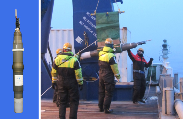
Figure 1. Deep-ocean profiling float “Deep NINJA” is deployed in the Antarctic Ocean from the R/V Mirai.
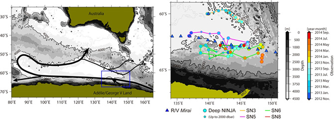
Figure 2. Left) Oceanic region in which this research took place. The black arrow represents the flow of the AABW. Right) Observation points by the “Deep NINJA” deep-ocean profiling floats and the R/V Mirai.
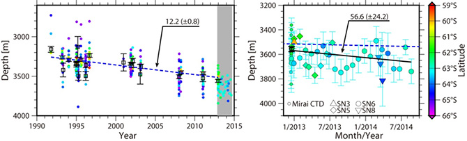
Figure 3. Depth changes at the upper boundary of the AABW at the reference station of 140°E 62°S. The square box with solid error bar represents the average and the standard error of the data collected during each observation cruise. As indicated here, the upper boundary of the AABW is getting deeper, meaning that the overall thickness of the AABW is decreasing. The average thinning rate beginning in the 1990s was 12.2 m/year (shown by the blue dashed lines), while the “Deep NINJA” observations showed a rate of 56.6 m/year (black solid line).
Contacts:
- (For this study)
- Taiyo Kobayashi, Senior Research Scientist, Research and Development Center for Global Change
- (For press release)
- Tsuyoshi Noguchi, Manager, Press Division, Public Relations