JAMSTEC > HPCI SPIRE Field3 > Results of Researches > Atmospheric Karman vortex shedding from Jeju Island, East China Sea: A numerical study

Atmospheric Karman vortex shedding from Jeju Island, East China Sea:
A numerical study
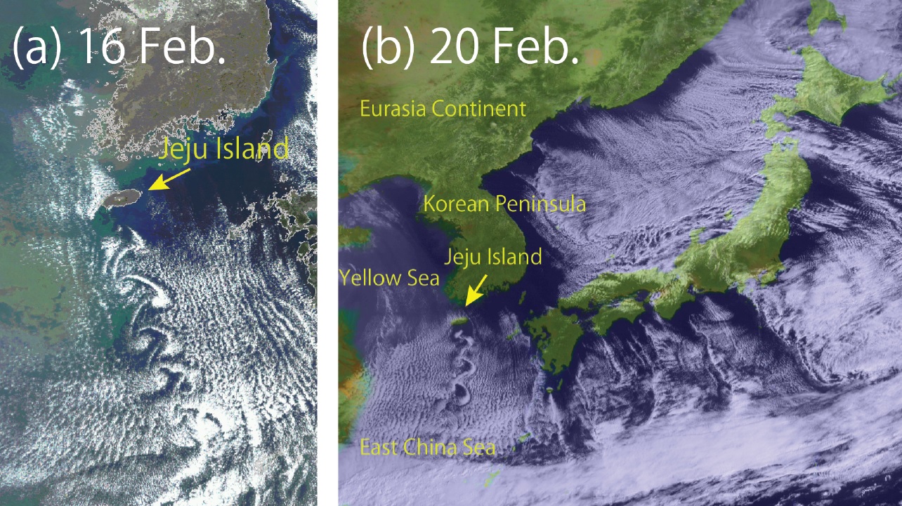
A mesoscale atmospheric numerical model is used to simulate two cases of Karman vortex shedding in the lee of Jeju Island, South Korea, in the winter of 2013 (Fig. 1). Observed cloud patterns associated with the Karman vortex shedding are successfully reproduced (Movie 1 and 2 and Fig. 2).
When the winter monsoon flows out from the Eurasian continent, a convective mixed layer develops through the supply of heat and moisture from the relatively warm Yellow Sea and encounters Jeju Island and dynamical conditions favorable for the formation of lee vortices are realized. Vortices that form behind the island induce updrafts to trigger cloud formation at the top of the convective boundary layer (Fig,3). A sensitivity experiment in which surface drag on the island is eliminated demonstrates that the formation mechanism of the atmospheric Karman vortex shedding is different from that behind a bluff body in classical fluid mechanics..
The detailed results of this study published in Monthly Weather Review, one of the journals of American Meteorological Society.
Atmospheric Karman vortex shedding from Jeju Island, East China Sea: A numerical study by Junshi Ito* and Hiroshi Niino, http://dx.doi.org/10.1175/MWR-D-14-00406.1
|
Fig. 1: a) A MODIS image of corrected cloud reflectance from the polar orbiter Terra at 0159 UTC 16 February (Courtesy of JAXA/ Tokai University) and (b) a visible image from the Geostationary Satellite MTSAT-2 at 0100 UTC 20 February 2013 (Courtesy of JMA/ Kochi University).

|

|
Movie 2: Vertically integrated cloud water (shading) with horizontal wind vectors at 844 m above the surface at 0000 UTC on 20 February 2013.
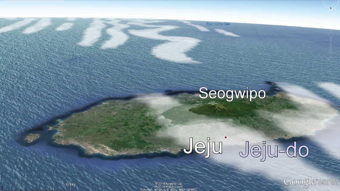
Fig. 2 Three-dimensional view of simulated cloud water mixing ratio overlaid on a Google Earth image by means of VDVGE at 0000 UTC on 16 February 2013.
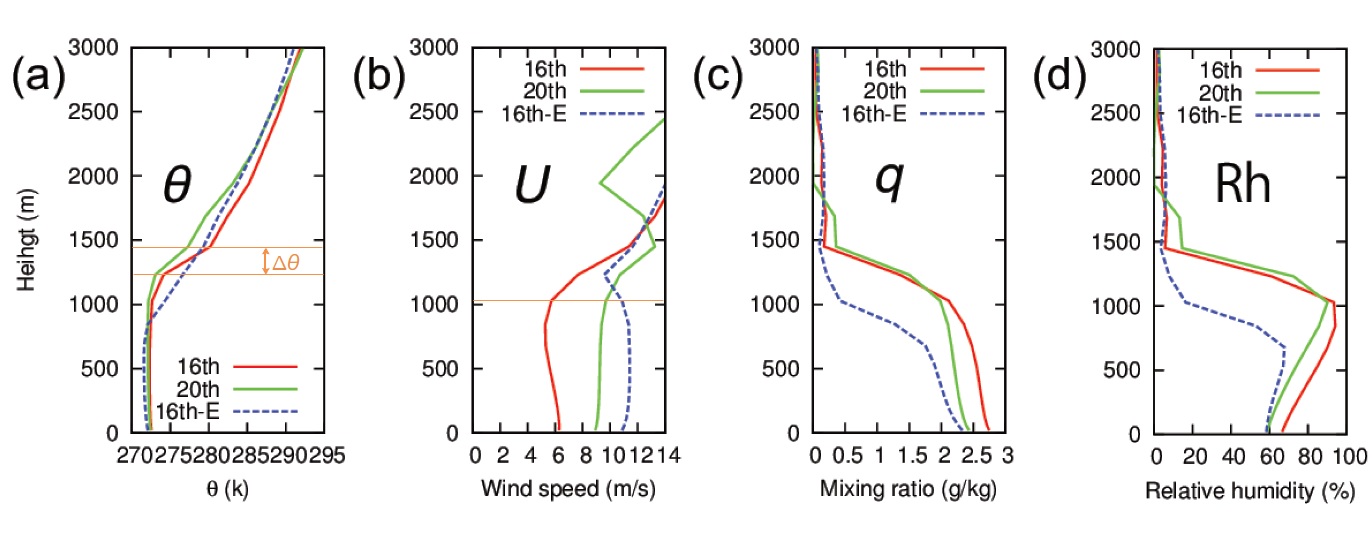
Fig. 3 Vertical profiles of (a) potential temperature, (b) wind speed, (c) water vapour mixing ratio, and (d) relative humidity just upstream of the Jeju Island at 0000 UTC on 16 (red solid line) and 20 February (green solid line).
Contacts:
Meteorological Research Institute/
Atmosphere and Ocean Research Institute, the University of Tokyo
Junshi Ito( /
/  )
)
Atmosphere and Ocean Research Institute, the University of Tokyo
Hiroshi Niino( )
)
Meteorological Research Institute/
Japan Agency for Marine-Earth Science and Technology
Kazuo Saito( )
)
Meteorological Research Institute/
Atmosphere and Ocean Research Institute, the University of Tokyo
Junshi Ito(
/ )Atmosphere and Ocean Research Institute, the University of Tokyo
Hiroshi Niino(
)Meteorological Research Institute/
Japan Agency for Marine-Earth Science and Technology
Kazuo Saito(
)