UNIT1: Research Unit for Ecosystem Changes
Current seafloor conditions will be determined by studying bathymetric features.
Just as a map is used when visiting a place you have never visited before, a detailed bathymetric map is essential for conducting an investigation on marine organisms and environments. No sufficient bathymetric data is available for the coastal region of Sanriku. In addition, landforms in some of the areas changed due to the earthquake. We are in the process of creating a detailed bathymetric map of the Sanriku coast after the earthquake by employing various techniques.
We investigated the distribution and decomposition processes of debris and elucidated the impacts of debris on marine ecosystems and fisheries.
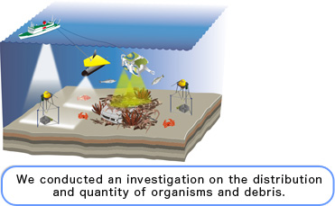
The tsunamis carried various onshore objects to the sea, some of which remain on the seafloor. It is likely that such debris has a significant impact on marine ecosystems and fisheries. We aim to investigate the type and location of debris and the extent to which it has been spread in hopes of providing information to promote the revitalization of fisheries.
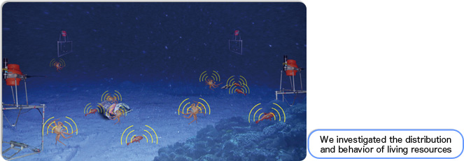
We aimed to elucidate the ecology of marine life on the seafloor offshore of Japan using biotracking systems.
We aimed to understand the impacts of the earthquake and tsunamis on organisms and restoration processes. In order to achieve that objective, it is essential to elucidate the types of organisms that exist along with where and how they live. We attempted to trace their behaviors by using a device called a biotracking system. It is our responsibility to protect the abundant oceans, which are considered Japan’s treasure. Until now, we have protected resources by establishing non-fishing periods, non-fishing areas, and catch limits based on fishermen’s experience. We hope to make a contribution to the actualization of more efficient fisheries while protecting resources by providing scientific data on the behavior of organisms and by conducting genetic analyses.