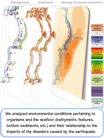
Current seafloor conditions will be determined by studying bathymetric features.
Just as a map is used when visiting a place you have never visited before, a detailed bathymetric map is essential for conducting an investigation on marine organisms and environments. No sufficient bathymetric data is available for the coastal region of Sanriku. In addition, landforms in some of the areas changed due to the earthquake. We are in the process of creating a detailed bathymetric map of the Sanriku coast after the earthquake by employing various techniques.
We investigated the distribution and decomposition processes of debris and elucidated the impacts of debris on marine ecosystems and fisheries.
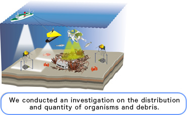
The tsunamis carried various onshore objects to the sea, some of which remain on the seafloor. It is likely that such debris has a significant impact on marine ecosystems and fisheries. We aim to investigate the type and location of debris and the extent to which it has been spread in hopes of providing information to promote the revitalization of fisheries.
We elucidated the impacts of the earthquake, tsunamis, and
restoration processes by conducting long-term monitoring of
marine environments from the sea surface to the seafloor.
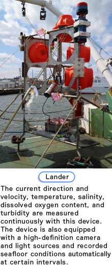
The marine environment has changed significantly due to the inflow of soil and sand from coastal areas, submarine slope failures, and the suspension of sediments on the seafloor caused by earthquake and tsunamis. We aim to elucidate how the earthquake and tsunamis affected the marine environment and how it will be restored.
In order to achieve that objective, it is essential to investigate continuously the physical, chemical, and biological marine environments from sea surface to seafloor sediments. Although this data may not directly and immediately be helpful for fishermen activity, it is essential to acquire basic data on marine environments to discuss future fisheries management strategies. Nothing would make us happier than knowing that our investigation led to the revitalization of the fisheries and that the individuals involved in fisheries found our work useful.
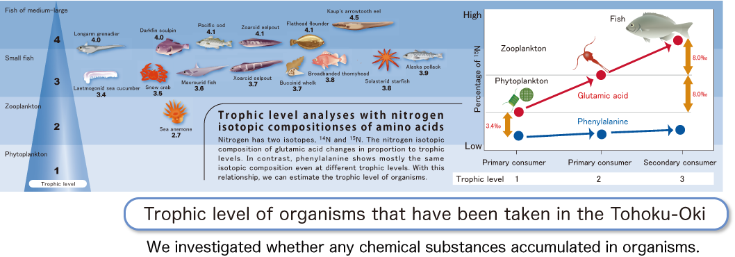
We represented the health of the ocean by
measuring chemical substances in organisms.
The tsunamis carried various objects from the land to the sea. Some of the objects contained the toxic substance PCBs (polychlorinated biphenyls). We aimed to elucidate the health of the ocean by measuring the level of PCBs contained in organisms and the sediments. Furthermore, we estimate trophic levels together with PCB analysis. Organisms at higher trophic levels play an important role in providing an overall picture of ecosystems. In other words, organisms at higher trophic levels tend to have increased longevity and serve as a useful monitor for understanding the levels of sea pollution via food chains. Therefore, it is very important to investigate trophic levels in addition to PCB concentration levels. Although PCB concentrations in sediments and organisms are currently below the reference values, we will continue to monitor the levels in the future.
We compiled various survey data on a map and elucidated
the current conditions of the ocean and organisms.
We created a habitat (suitable area for organisms) map for the areas off Sanriku. Our habitat map not only presents information on the distribution of organisms, but also integrates information on habitat environments. Information on bathymetric features, geological features of the seafloor surface, debris distribution, organism distribution, and marine environments is individually very important. However, overlaying multiple pieces of information helps clearly reveal a relationship between organisms and the environment, such as desirable or undesirable living areas for organisms or differences between the types of organisms.
Our habitat map is not limited to making a positive contribution to the re covery of fisheries; it also serves as a useful tool for various research activities. It is expected to make new discoveries by integrating information that has not been utilized in the past.
We make the results open to the public.
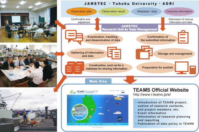
We are responsible to manage and disclose the data obtained through investigations conducted by TEAMS. In addition to the three primary institutions, JAMSTEC, Tohoku University, and the Atmosphere and Ocean Research Institute of the University of Tokyo (AORI), various institutions participate in TEAMS. Sharing information is essential to efficiently achieve their aims. In TEAMS, we play a role in providing information just as a bloodstream transports nutrients to every part of the body.
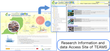
The data obtained from investigations consists of various fields to cover biology, chemistry, physics, and geoscience. The type of data is diverse as it contains numerical values, videos, and images, and the quantity of data is enormous. We are building a database that systematically organizes collected data to help individuals utilize the information they need. This database is made available on the official website to researchers, people from disaster-striken areas, and the general public.
Please check our official website to find the database and more information on the details of our investigations, our research plans, and relevant events.
TEAMS Official Site: http://www.i-teams.jp/e/