


Integrated Ocean Drilling Program Expedition 348 Scientific Prospectus
NanTroSEIZE plate boundary deep riser 3
The Digital Object Identifier (DOI) for the report is doi:10.2204/iodp.sp.348.2013
>>Published (2013.10.31)
NanTroSEIZE plate boundary deep riser 3
The Digital Object Identifier (DOI) for the report is doi:10.2204/iodp.sp.348.2013
>>Published (2013.10.31)
▲Click for full size
The Research Vessel Kaiyo has been deployed on a research cruise since January 18, 2013. The long-term borehole observatory, which was installed by the Deep Sea Drilling Vessel Chikyu beneath the seafloor of the Kumano Basin off the Kii Peninsula in the projected focal region of the Tonankai earthquake, in December 2010, was connected by the Kaiyo to the Dense Oceanfloor Network System for Earthquakes and Tsunamis (DONET) that is being deployed and operated in this ocean area. The data collected by the long-term borehole observatory (strain, temperature, pore-fluid pressure, seismic waves, etc.) were successfully received in real-time; the data quality was verified at basic levels and it was confirmed that observations were effective for scientific research.
This is the world's first real-time data acquisition from seismic and geodetic sensors installed in a borehole beneath the seafloor connected to a submarine cable monitoring network. This will allow investigation of changes beneath the seafloor in crustal strain, temperature, pore-fluid pressure, etc., associated with micro-earthquakes or deformations in the earth's crust and their relationship to the occurrence of large earthquakes. The anticipated findings should contribute to understanding of the mechanisms of earthquakes. In addition, this will allow real-time observation on micro-earthquakes and crustal deformations that would be difficult to monitor with ground-based or seafloor surface-sited observatories. The use of data in disaster management and mitigation applications is highly expected.
Future plans include detailed verification of the quality of the data obtained from the long-term borehole observatory and coordination with organizations monitoring earthquakes in the projected focal region of the Tonankai Earthquake for data distribution.
In addition, it is planned to install a long-term borehole observatory in other locations in the same ocean area that will be connected to the DONET submarine cable monitoring network as well.
>>Dense Oceanfloor Network System for Earthquakes and Tsunamis (DONET)


▲Click for full size
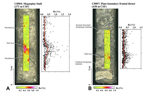
The core samples obtained around the mega splay fault in the region during the IODP Nankai Trough Seismogenic Zone Experiment (NanTroSEIZE): Stage 1 Expedition 316 were analyzed using X-ray computed tomography (X-CT), which provides three-dimensional images of the interior of an object. The research team found a structure called mud breccia, formed by strong seismic shaking, and used it for radiometric dating. As a result, it was revealed that the splay fault moved during the recorded 1944 Tonankai Earthquake.
The study demonstrated that it is possible to identify which deep subseafloor formations moved during which great earthquakes in the past using geological evidence. This finding allows us to estimate the scale of ao massive earthquake, based on an assumption that mega splay faults may move, and hence will contribute to more accurate estimation of consequences.
Their work was published in the October issue of the American journal "Geology".
Episodic seafloor mud brecciation due to great subduction zone earthquakes


▲Click for full size
An international group of researchers has discovered evidence of tsunami source regions for the first time in the world. Detailed analyses of the core samples recovered by Deep Sea Drilling Vessel Chikyu during IODP Nankai Trough Seismogenic Zone Experiment (NanTroSEIZE): Stage 1 Expedition 316 revealed that a seismic rupture had occurred at the upper portion of the mega splay fault.
Their work was published in the April issue of the journal Geology.
論文タイトル:Seismic slip propagation to the updip end of plate boundary subduction interface faults: Vitrinite reflectance geothermometry on Integrated Ocean Drilling Program NanTroSEIZE cores
Their work was published in the April issue of the journal Geology.
論文タイトル:Seismic slip propagation to the updip end of plate boundary subduction interface faults: Vitrinite reflectance geothermometry on Integrated Ocean Drilling Program NanTroSEIZE cores


▲Click for full size

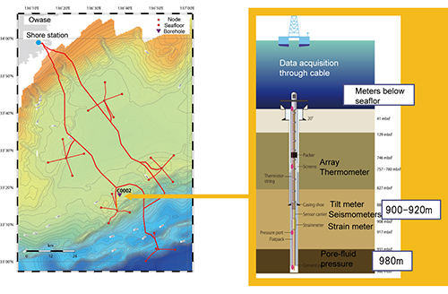
Integrated Ocean Drilling Program (IODP) Expedition 332 successfully deployed a long-term borehole observatory, which was developed as part of the ocean and earth exploration system, a project pursued as one of Japan’s “Key Technologies of National Importance”. The observatory is installed between approximately 750 and 940 m below the seafloor surface in a one-kilometer borehole in the Kumano basin, and it consists of several sensor arrays: (1) strain indicator, (2) inclinometer, (3) thermometer, (4) pore fluid pressure gauge, (5) wideband seismometer, (6) short-period seismometer, and (7) strong-motion seismometer. Especially in event of earthquakes, the realtime geophysical observations and retrieval of data will provide invaluable insights into the mechanism of great earthquakes.
Scientists plan to deploy a permanent borehole observatory to monitor earthquakes and tsunamis in and around the source region of the Tonankai Earthquake. Connecting the observatory with the Dense Oceanfloor Network System for Earthquake and Tsunamis (DONET) placed in the Kumano Basin will establish an integrated monitoring network covering the seafloor and subseafloor crust. This will enable real-time observation of seismic activities in the earthquake-prone Tonankai region.
Scientists plan to deploy a permanent borehole observatory to monitor earthquakes and tsunamis in and around the source region of the Tonankai Earthquake. Connecting the observatory with the Dense Oceanfloor Network System for Earthquake and Tsunamis (DONET) placed in the Kumano Basin will establish an integrated monitoring network covering the seafloor and subseafloor crust. This will enable real-time observation of seismic activities in the earthquake-prone Tonankai region.


"Our knowledge of megasplay faults up till now has been based on seismic or modelling experiments accomplished over the last twenty years," says Michael Strasser of Post-Doc Fellow of the Center for Marine Environmental Sciences (MARUM) at University of Bremen. "For the first time, with cored samples brought onto the CHIKYU, it has become possible to reconstruct the geological history of a fault in great detail." With his associates, Dr. Strasser found that the fault in the Nankai Trough originated about two million years ago. From the information recorded in the cores, the research team can draw conclusions on the mechanics of the accretionary wedge. They also can infer in which geological time periods the fault was most active.
"Our most significant conclusion is that splay fault activity varies through time," Dr. Strasser states. According to Strasser, after an initial period of high activity, the movement along the fault slowed down. Since about 1.55 million years ago, this fault has been reactivated, favoring ongoing megasplay slip along it.
"It is absolutely fascinating to be part of NanTroSEIZE," says Strasser, noting that the expedition series aims to sample and monitor activity at the point where earthquakes originate. "NanTroSEIZE is something completely new and innovative in scientific drilling," Strasser explains. "Ultimately, we hope to detect signals occurring just before an earthquake to get a better understanding of the processes leading to earthquakes and tsunamis."
The Nankai Trough is particularly suited for this experiment because historical records of earthquakes and tsunamis in this area date back into the seventh century. Additionally, the area where earthquakes are generated, the so-called seismogenic zone, is located at a relatively shallow depth of about six kilometers below the seafloor.
In 2007 and 2008, during the first stage of NanTroSEIZE, the deep sea drilling vessel CHIKYU carried out three expeditions. This drilling project consists of four stages in all, and ultimately focuses on "ultra-deep" drilling that can reach the seismogenic zone, where great earthquakes have occurred repeatedly.
During upcoming expeditions, the Nankai Trough boreholes will be equipped with instruments to establish an ocean observatory network. Currently, scientists are making preparations to install monitoring devices for continous measurements of the Nankai Trough. Prof. Gaku Kimura of University of Tokyo, who led an earlier NanTroSEIZE expedition 316 as Co-Chief Scientist says, "Not only do we have new insights about historic fault activities in Nankai Trough, but the data strongly suggests that the megasplay fault may be a key factor in the occurrence of large earthquakes in the future." He adds, "Greater understanding about the processes of earthquake and tsunami generation in the active subduction zone will be a great contribution to society."
Origin and evolution of a splay-fault in the Nankai accretionary wedge


■TOPICS
■IODP Proceedings
Expedition 314 - 316
Expedition 319
Expedition 322
Expedition 326
Expedition 332
Expedition 333
Expedition 338(In preparation)
Expedition 319
Expedition 322
Expedition 326
Expedition 332
Expedition 333
Expedition 338(In preparation)


