October 3, 2011
JAMSTEC
Evidence for Rupture Caused by 1944 Tonankai Earthquake
- NanTroSEIZE Drilling Project by Chikyu Reveals -
Overview
A group of researchers from JAMSTEC, The University of Tokyo, and Kochi University discovered evidence of a seismic rupture caused by the 1944 Tonankai Earthquake, a massive earthquake which had occurred in Nankai Trough, off southwest Japan. The core samples obtained around the megasplay fault in the region during the IODP(*1)NanTroSEIZE(*2) Expedition 316 were analyzed using X-ray computed tomography (X-CT)(*3). The X-CT provides three-dimensional images of the interior of an object.
The 3D images revealed that the uppermost core at one site contained repeated occurrences of mud breccia, a clastic sediment composed of soft mud fragments and clay, which was formed by strong seismic shaking. Radioisotope dating of the uppermost mud breccia indicates a deposition time consistent with the 1944 Tonankai earthquake, suggesting that the mud-breccia layer is a result from the breacciation caused by seismic shaking.
The study demonstrated that mud brecciation can be an effective tool to identify submarine faults responsible for earthquakes in historical records in the subduction zone. This will allow researchers to estimate the reoccurrence and magnitude of seismic events along each fault, which contributes to developing effective strategies for earthquake disaster mitigation.
Their work was published in the October issue of the American journal "Geology".
- Title:
- Episodic seafloor mud brecciation due to great subduction zone earthquakes
- Authors:
- Arito Sakaguchi1, Gaku Kimura2, Micheal Strasser3, Elizabeth J. Screaton4, Daniel Curewitz5
1.JAMSTEC, 2.The University of Tokyo, 3.University of Bremen, 4.University of Florida, 5.Syracuse University, 6.Kochi University
Background
Submarine faults responsible for the past mega-thrust earthquakes and their seismic history have been conventionally studied using ancient earthquake and tsunami records or their geological remnants on land. With a pressing need to develop more effective measures against earthquakes, it is important to identify seismogenic faults and develop measures based on their earthquake history. Geologic signatures that record accurate times and locations of the past seismic events are therefore particularly useful.
Results
Researchers focused on brecciation of sediment, a deformational process on the seafloor surfaces caused by strong seismic shaking (Fig. 1). Brecciation of cohesive material, such as mud, is created by even greater motion, and thus assumed to preserve information about the past seismic activity. As mud breccias are too small to observe with the naked eye, X-CT image observation was employed for analysis.
The core samples retrieved around the megasplay fault during the IODP Expedition 316 were provided for analysis. The X-CT images indicated five stratified mud breccias in the upper 80 cm portion of the core from the hanging wall(*4) slope(Site C0004) (Fig. 2).
In contrast, the cores taken from the foot wall(C0008) consist of homogeneous silt and do not contain mud breccias. In a reverse-fault earthquake, typical in the Nankai trough, the seismic ground motion is much greater on the hanging wall, causing major damage to structures on that surface (e.g. the Iwate-Miyagi Nairiku Earthquake in 2008 and the 1999 earthquake in central Taiwan). The episodic mud brecciation, observed only on the hanging wall of the magasplay fault, suggests that the seismic slip along the megasplay fault could have been responsible for the greater seismic ground motion on this side.
Furthermore, the mud-breccia units were dated using radioisotope lead (210Pb, a half life of 22.3 years) and carbon (14C, a half life of 5730 years) methods. The most recently formed unit 1 was dated A.D. 1950 (±20), which is consistent with the 1944 Tonankai earthquake (Fig. 2). The older units were dated between A.D. 3,500 and 10,000 years ago but no corresponding earthquakes were recorded in history.
Given the intervals of major earthquakes in the Nankai region, which are thought to occur every 100 to 150 years, the mud breccias in the studied core do not seem to record every large event in the past. This implies that mud breccias may not signify every large seismic event over the historical records but only ones with greater magnitude and longer intervals.
Future perspectives
The study has presented a new approach to reconstruct the ancient earthquake history in the subduction zone. It will allow researchers to incorporate seismic behavior of the megasplay fault in estimating the recurrence and magnitude of future earthquakes, thereby helping to develop effective measures against earthquake hazards.
The evidence for seismic slip at a deeper portion of the core from the same site was reported in an earlier press release dated on April 28, 2011.
*1. The Integrated Ocean Drilling Program (IODP) is an international marine research drilling program dedicated to advancing scientific understanding of Earth by monitoring, and sampling subseafloor environments. Through multiple platforms, scientists explore IODP principal themes: the deep biosphere, environmental change, and solid Earth cycles. IODP has operated since October 2003, funded jointly by the Japan Ministry of Education, Culture, Sports, Science and Technology and the U.S. National Science Foundation. Additional support is provided by the 17-member European Consortium of Ocean Research Drilling, the People's Republic of China, the Republic of Korea, Australia, India, and New Zealand.
*2 Nankai Trough Seismogenic Zone Experiment (NanTroSEIZE)
Project outline
The NanTroSEIZE drilling project consists of four stages in all, designed to conduct drilling operations at several sites located along a line orthogonally crossing the Nankai Trough region from Shikoku Basin (seaward) to Kumano Basin. Stage 1 of the NanTroSEIZE completed on February 5, 2008.
Stage 1
Expeditions involved riserless drilling into the shallow portions (at a depth of 1400 mbsf and above) of the megasplay fault and plate boundary thrust. Data were collected to characterize subsurface geologic distribution, deformation structure and state of stress.
Stage 2
The goal of Stage 2 is to penetrate the upper portion of the seismogenic zone of great earthquakes and unravel its geological structure and state, using riser and riserless drilling. The drilled holes are to be used for the future installation of long-term observatories to monitor earthquake generation processes. Coring the subduction inputs before they are transported to the seismogenic zone is also planned to document their initial conditions including composition, architecture and geophysical properties.
Stage 3
Expeditions will focus on "ultra-deep" drilling that can reach the seismogenic zone, on which great earthquakes have repeatedly occurred. Operations include direct core sampling from the seismogenic zone to understand the seismogenic mechanism from a material science point of view.
Stage 4
In this Stage, long-term observatories will be deployed in the ultra-deep borehole. Ultimate future goals include connecting the NanTroSEIZE borehole sensors to an underwater seismic monitoring network, called Dense Ocean-floor Network for Earthquakes and Tsunamis (DONET), so that real-time data from earthquake occurring sites can be made available.
*3. X-ray computer tomography(X-CT)
X-ray computer tomography is widely used in medical applications. It creates three-dimensional images of the inner part of an object by scanning X rays. Over the past 10 years, the X-CT scanning has been increasingly valued in earth science research. The deep-sea Drilling Vessel Chikyu was the first to be equipped with X-CT scanning for scientific drilling.
*4. Hanging wall and foot wall of the fault
In a reverse fault, like ones often observed in the Nankai trough, the rock block overlying the fault plane is called a "hanging wall" and the one below the fault plane is called a "footwall". The hanging wall is subject to greater seismic shaking, resulting in more serious damage to objects on the hanging wall surface.
*DONET (Dense Ocean-floor Network System for earthquakes and Tsunamis)
DONET is a cabled ocean-floor observatory network established to achieve real time monitoring of seismic and tsunami activities, including the possible Tonankai earthquake, in the Kumano Basin, off the Kii peninsula. The data collected are used not only to better prepare for earthquakes and tsunamis but also for clarifying mechanisms of earthquake generation. Using wired sensor packages placed at multiple locations ranging from depths of 1,900 to 4.300 meters, DONET will allow for simultaneous, real-time, and multipoint measurements at the deep sea bottom, which had not been possible with conventional observatory networks. The looped backbone cable of the system extends from the land station in Furue, Owase City, in Mie Prefecture, to 125 km off shore. The total length of the cable is approximately 250 km. The cable is connected with branching units, called nodes, at five locations. Each node is connected to four sensor packages, each equipped with sensors including a seismometer and pressure gauge. The power is supplied via the backbone cable and the optic fiber in it transmits data collected at each package to the land station. The data are then transmitted to JAMSTEC, JMA and NIED using a dedicated line that connects the three agencies.
The DONET project falls under the umbrella of the "Development of the Dense Ocean-floor Network System for earthquakes and Tsunamis" which is funded by the Ministry of Education, Sports, Culture, Science and Technology.
Appendix
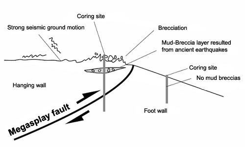
Figure 1. Schematic diagram of mud brecciation caused by earthquakes
A strong shaking caused by earthquakes fractures sediments on the hanging wall, creating a breccia structure. In a reverse fault, typically observed in the area of increased pressure such as the Nankai trough, the hanging wall is exposed to a stronger seismic ground motion, resulting in the brecciation of the surface sediment. Brecciation rarely occurs on the foot wall.
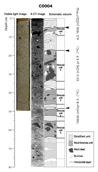
Figure 2. X-ray computed tomography (X-CT) of the core retrieved from the hanging wall (sample from Site C0004).
An image taken under the visible light shows no brecciation of sediment. X-CT can visualize minute differences in sediment type. The schematic column interpreted from the X-CT image shows five units of stratified brecciated mud (indicated by Event 1 to 5). Radioisotope dating revealed that the uppermost mud breccia (Event 1) was created in A.D. 1950 (±20), which is consistent with the 1944 Tonankai earthquake (Fig. 2). Other mud breccias units were not consistent with those recorded in the earthquake history.
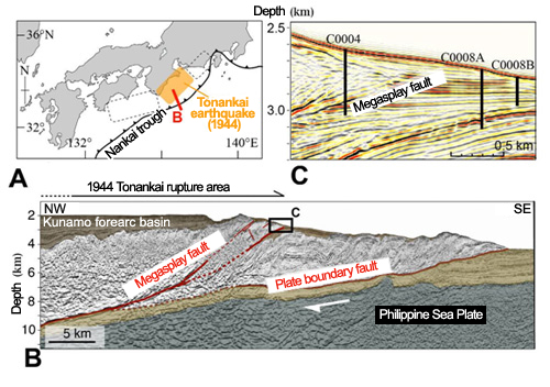
Figure 3.
A: Tectonic setting of Nankai Trough subduction zone. Large earthquakes (magnitude 8-class) have repeatedly occurred along the Nankai Trough. The orange shaded segment caused the 1944 Tonankai earthquake. The NanTroSEIZE project is underway along the red line B.
B: Cross section (red line in A). Detailed seismic profiles illustrate the plate boundary fault and the megasplay fault.
C: Locations of core samples from Sites C0004 and C0008, taken from hanging wall and the footwall, respectively.
Contacts:
- Japan Agency for Marine-Earth Science and Technology
(For the study) - Arito Sakaguchi, Research Scientist
Solid Earth Dynamics Research Program
Institute for Research on Earth Evolution (IFREE) - (For publication)
- Hikaru Okutsu, e-mail: press@jamstec.go.jp
Senior Administrative Specialist, Planning Department Press Office