February 5, 2008
The Japan Agency for Marine-Earth Science and Technology
Integrated Ocean Drilling Program (IODP)
Nankai Trough Seismogenic Zone Experiment (NanTroSEIZE)
Scientists on Expedition 316 Successfully Obtain Core Samples
from the Megasplay Fault System
1. Outline
The Japan Agency for Marine-Earth Science and Technology (JAMSTEC; Mr. Yasuhiro Kato, President) is pleased to announce that the Deep-sea Drilling Vessel Chikyu has just completed IODP*1 Expedition 316 of the Nankai Trough Seismogenic Zone Experiment (NanTroSEIZE) as of February 5th.
2. Expedition 316 overview
The Expedition 316 has completed 49 days mission carrying out scientific drilling in the Kumano basin off the Kii Peninsula from December 19th to February 5th. The main scientific objective of this expedition was to comprehensively evaluate the deformation, structural partitioning, and fault zone physical characteristics at the frontal thrust and at the megasplay system at Nankai Trough.
Dr. Gaku Kimura (Professor, Department of Earth and Planetary Science, University of Tokyo, Japan) and Dr. Elizabeth J. Screaton (Associate Professor, Department of Geological Sciences, University of Florida, USA) are the Co-Chief Scientists, while the science party comprises 26 onboard scientists from 10 countries.
3. Primary operational results
Sites C0004 and C0008 (Fig.1) examined the shallow portion of the megasplay system of Nankai Trough, and the frontal thrust system was studied at Sites C0006 and C0007. A total of 13 holes were drilled and core sample from fault zone were successfully collected.
Site C0004 is located along the slope of the accretionary prism (*2) landward of the inferred intersection of the megasplay fault zone with the seafloor. At this Site, the accretionary prism was sampled and the megasplay fault zone was successfully drilled. The cores from the fault zone record a complex history of deformation, based on structural observations and two age reversals suggested by nannofossil evidence. The sediments underneath the fault zone were sampled to understand their deformation, consolidation, and fluid flow history. Drilling at this site examined the youngest sediments on the slope overlying the accretionary prism; these sediments consist of slowly deposited marine sediments and redeposited material from further upslope. This redeposited material provides information about past slope failures, which may be related to past megasplay movement and Earthquakes that may cause Tsunamis.
Moreover, the Site C0007 drilled through the plate boundary frontal thrust, and successfully recovered thrust fault material. One of the recovered cores documents an age reversal of more than 1 million years. This interval exhibits deformation caused by fault movement from large pieces to fault gouge (ground into smaller pieces by the movement of the fault).
More than 5000 samples were taken from these cores to be further examined by an international scientist group. The data collected at these sites and from post-cruise analysis of samples will provide important new constraints on models of the evolution of the subduction zone and its relationship to Earthquake and Tsunami generation.
4. Future schedule
The Chikyu will depart the Port of Shingu on February 12th to the Kochi New Port for unloading the core samples. Base office in Shingu and Heliport in Minami-Ise will be closed until next NanTroSEIZE expedition starts in fall 2008.
- (*1):
-
Integrated Ocean Drilling Program (IODP)
The Integrated Ocean Drilling Program (IODP) is an international marine research drilling program dedicated to advancing scientific understanding of Earth by monitoring and sampling subseafloor environments. Through multiple platforms, preeminent scientists explore IODP principal themes: the deep biosphere, environmental change, and solid earth cycles. IODP has been operating since October 2003, led by Japan and the USA. IODP now has 21 member countries. - (*2):
- Accretionary Prism
The Nankai Trough runs from the Suruga Bay, through off Tokai, Kii and Shikoku, and to off Kyushu, where the Philippine Sea Plate is subducting under the southwest Japan (Usually, trough indicates a topographic feature having an elongated depression, but here means trench, one is approximately 770 km long). Along this subduction zone, sediment on the plate is being scraped off and added to the continental plate, with such newly-formed geological sediments called Accretionary prism. Its development and history are very important in understanding the basic process of orogenesis, and front-line research is being conducted in the seismogenic zone.
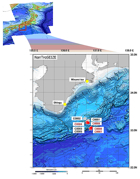
Fig.1 Survey Area
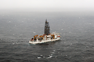
Pictures: Deep Sea Drilling Vessel Chikyu operated drilling at Nankai Trough
(Photographed on January 21st 2008)
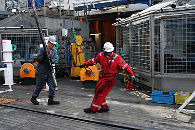
Pictures: Core barrel contains geological samples was recovered on deck
(Photographed on January 21st 2008)
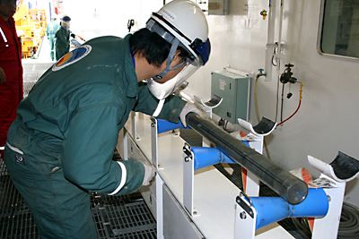
Pictures: Curation staff examines the core at Core Cutting Area
(Photographed on January 21st 2008)

Pictures: International group of shipboard scientists discussed about sampling in the laboratory
(Photographed on January 18th 2008)
Summary of Coring Operation
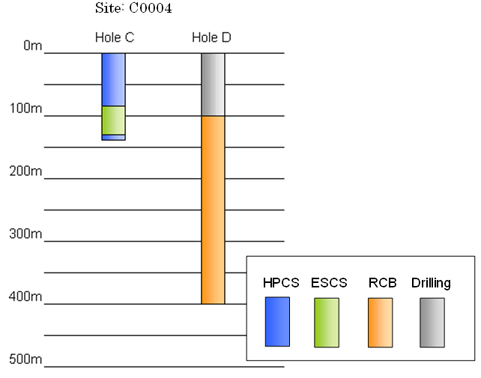
| Drilling site: C0004(Proposed site:NT2-01I) | |||
| North Latitude:33°13.0’ East Longitude:136°43.0’ | |||
| Hole Name |
Water depth | Core sampling depth (below seafloor) |
Summary of Result |
|---|---|---|---|
| C | 2627.0m | 0~89.2m (HPCS) ~127.2m (ESCS) ~135.0m (HPCS) |
131 meters cored, 135 meters recovered in slope basin, slope apron deposits. Evidence for unconformity, minor faulting, and understanding of sedimentary processes in shallow trench slope deposits. |
| D | 2630.5m | 0~100.0m (Drilled) ~400.0m (RCB) |
300 meters cored, 130.7 meters recovered in accretionary prism deposits, upper portion of megasplay, and underthrust slope basin deposits. Evidence for faulting, recovery of a wide variety of fault rocks. Understanding of the internal deformation of the accretionary prism and the mechanism by which the prism rocks are being thrust up and over slope basin deposits. Will shed light on timing and degree of thrust faulting in the megasplay system. |
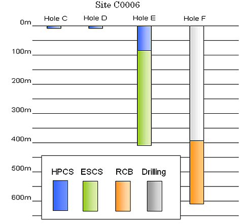
| Drilling site:C0006(Proposed site:NT1-03B) | |||
| North Latitude:33°01.0’ East Longitude:136°47.0’ | |||
| Hole Name |
Water depth |
Core sampling depth (below seafloor) |
Summary of Result |
|---|---|---|---|
| C | 3880.5m | 0~9.5m (HPCS) | Single core in sediments above the hanging wall of the frontal thrust. Hole abandoned because sediment-water interface was not recovered. |
| D | 3877.5m | 0~9.5m (HPCS) | Same as above |
| E | 3875.8m | 0~79.3m (HPCS) ~409.4m (ESCS) |
409 meters cored, 330.3 meters recovered in sediments deposited on the hanging wall of the frontal thrust and in rocks making up the accretionary prism material that has been transported along the frontal thrust. Several age reversals, recovery of many different kinds of fault rocks, recovery of a wide array of materials comprising the thrust sheet. Will shed light on the internal deformation and tectonic history of the deformed accretionary prism. |
| F | 3875.5m | 0~395.0m (Drilled) ~ 603.0m (RCB) |
208 meters cored, 56.4 meters recovered in the rocks making up the older portions of the hanging wall of the frontal thrust system. Several faults and different kinds of fault rocks recovered in association with age reversals. Will shed light on the internal deformation and history of the hanging wall of the frontal thrust system. Hole had to be abandoned due to deteriorating drilling conditions. |
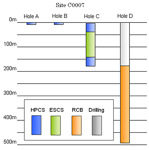
| Drilling site:C0007(Proposed site:NT1-03A) | |||
| North Latitude:33°01.0’ East Longitude:136°47.0’ | |||
| Hole Name |
Water depth |
Core sampling depth (below seafloor) |
Summary of Result |
|---|---|---|---|
| A | 4081.0m | 0~3.1m (HPCS) | Single core taken at the sediment-water interface. |
| B | 4081.0m | 3.1~12.6m(HPCS) | Single core taken from 3.14 t0 12.5 meters. For operational and curatorial reasons the hole was renamed, but is the same as Hole A and Hole C. |
| C | 4081.0m | 12.6~43.0m(HPCS) ~147.5m (ESCS) ~176.0m (HPCS) |
163.4 meters cored, 59.3 meters recovered in the sediments uplifted by transport along the frontal thrust. Will shed light on the timing and extent of thrust faulting along the frontal thrust. As a result of coring in sand, the hole had to be abandoned after mechanical failure of the coring equipment. |
| D | 4049.0m | 0~175.0m (Drilled) 493.5m (RCB) |
318.5 meters cored, 87.9 meters recovered in uplifted trench deposits and into older materials transported along the frontal thrust. Sampling of a wide array of faults and fault rocks, and sampling of the material in the footwall of the frontal thrust will shed light on the timing and degree of shortening, the mechanisms for internal deformation within the accretionary prism, and the tectonic history of the frontal thrust region. |
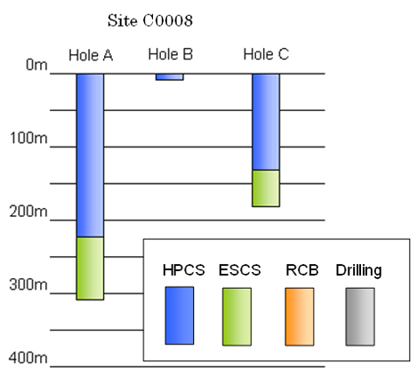
| Drilling site:C0008(Proposed site:NT2-10A) | |||
| North Latitude:33°12.0’ East Longitude:136°43.0’ | |||
| Hole Name |
Water depth |
Core sampling depth (below seafloor) |
Summary of Result |
|---|---|---|---|
| A | 2751.0m | 0~224.7m (HPCS) ~357.7m (ESCS and HPCS) |
357.7m cored, 271.2m recovered in clay and sand deposited in a slope basin just trenchward of the megasplay fault system. Recovery of a wide array of sedimentary materials and sedimentary structures will shed light on the depositional systems and changes in depositional patterns associated with structural changes in the accretionary prism over recent geological periods. Understanding of the character of slope basin deposits before they are incorporated into the accretionary prism during underthrusting, and comparison to similar materials sampled beneath the megasplay fault will allow understanding of the changes in physical state of materials over time during tectonic compression and thrust faulting. |
| B | 2,796.3m | 0~9.5m (HPCS) | Single core recovered in clay and sand deposited in a slope basin just trenchward of the megasplay fault system. Hole abandoned because sediment-water interface was not recovered. |
| C | 2,797.0m | 0~139.1m (HPCS) ~176.2m (ESCS) |
176.2m cored, 189.6m recovered in a slope basin just trenchward of the megasplay fault system. |
*About core sampling system
Hydraulic Piston Core Sampling System (HPCS):
Applied to very soft formations. Stub edgy tip like knife into layers using hydraulic pressure, and collect core without rotate drill bit.
Extended Shoe Coring System (ESCS):
Applied to soft formation that is difficult to collect. Tip of the system can adjust to layers intensity using spring power.
Rotary Core Barrel Sampling System (RCB):
Applied to layers of middle to high intensity. Collect samples while rotating drill bit and scraping layers. Good for consolidated layers with less ruptures.
Drilled only:
Zone at where only drilling was operated (no core sampling) in accordance with scientific objectives.
Contacts:
- (For Chikyu)
-
Mr. Takeo Tanaka, e-mail: cdex@jamstec.go.jp
Manager, Planning and Coordination Department
The Center for Deep Earth Exploration (CDEX)
Japan Agency for Marine-Earth Science and Technology
- (For Research)
- Dr. Gaku Kimura
Co-Chief Scientist of Expedition 316
Professor, Department of Earth and Planetary Science,
University of Tokyo, Japan
TEL: +81-3-5841-4510 -
Dr. Elizabeth J. Screaton
Co-Chief Scientist of Expedition 316
Associate Professor, Department of Geological Sciences,
University of Florida, USA
TEL: +1-352-392-4612
- (For Publication)
- Mr. Shinji Oshima, e-mail: press@jamstec.go.jp
Manager, Planning Department Press Office
Japan Agency for Marine-Earth Science and Technology