June 26, 2009
Japan Agency for Marine-Earth Science and Technology
Integrated Ocean Drilling Program (IODP)
Nankai Trough Seismogenic Zone Experiment (NanTroSEIZE)
Expedition 319
Deep-Sea Drilling Vessel Chikyu Starts Riser Drilling
1. Overview
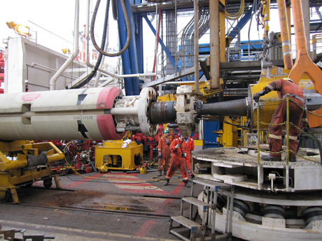
The Deep-sea Drilling Vessel CHIKYU, operated by the Japan Agency for Marine-Earth Science and Technology (JAMSTEC: Yasuhiro Kato, President) began the first phase of drilling operations for the 2009 IODP(*1) Nankai Trough Seismogenic Zone Experiment (NanTroSEIZE)(*2), off the Kii Peninsula (approximately 58 km southeast of Shingu City: Fig.1). She sailed out from the Port of Shingu at 17:00 on May 12, 2009, and arrived at the first drill site NT2-11(water depth: 2,054 m) at 23:00 on the same day. Following sea floor surveys and acoustic transponder deployment, the crew began fitting the rise pipe and a blow-out prevention system (BOP) to an upper section of the first borehole to be drilled (Photo.1). The rise pipe was successfully connected to the well head. After testing the circulation of drilling fluid, the first riser-drilling operations in the history of scientific ocean drilling began on June 25. Drilling operations are proceeding almost on track.
Following drilling operations up to a target depth of 1,600 meters beneath the sea floor, vertical seismic profiling (VSP)(*2) is scheduled to begin as part of geophysical logging.
The above schedule is subject to change depending on the progress of drilling operation and weather. The daily report from the CHIKYU is available online at:
http://www.jamstec.go.jp/chikyu/eng/Expedition/NantroSEIZE/special.html
2. Riser drilling
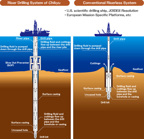
Riser drilling involves a large marine riser pipe that connects the CHIKYU and the seafloor. The riser pipe guides the drill pipe as it reenters the well. Drilling fluid is pumped up and down between the riser pipe and the drill pipe. Fluid circulation and use of the blow-out preventer (BOP) help maintain pressure balance within the borehole and prevent it from collapsing, enabling safer and deeper drilling (Fig.2).
Conventional scientific drilling vessels, including U.S. JOIDES Resolution and European mission-specific vessels, do not have a riser system. The CHIKYU is the worlds first scientific drilling vessel capable of riser drilling deep beneath the ocean floor and in seismogenic(earthquake-producing) zones that have never been reached before. It is expected to bring about exciting discoveries of the Earths deep interer.
The Nankai Trough subduction zone, located southwest of Japan, is one of the most active earthquake zones on the planet, with complex geological formations caused by tectonic plate thrusts. The scheduled drill site, the Kumano Basin, is a fore-arc basin of the Nankai Trough under the influence of the strong Kuroshio ocean current. In combination with inclement weather expected, due to passing typhoons, and riser drilling down to depths of more than 2,000 meters below surface, this phase of NanTroSEIZE is considered one of the most challenging tasks in ocean-drilling history.
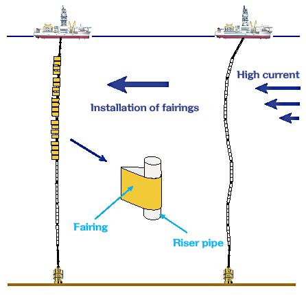
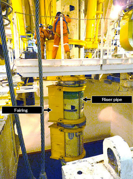
The average speed of the Kuroshio current in the surveyed area is approximately 1.0 knots, relatively slow for the current speed usually observed in the Kumano Basin. Yet, fairings are to be mounted on a riser pipe to smooth the hydrodynamic flow behind the riser pipe (to reduce riser drag) and suppress the vortex-induced vibration under high current conditions. The motion of the riser also will be monitored for analysis, in order to use the results in future operations (Fig.3 and Photo.2).
*1 IODP(Integrated Ocean Drilling Program)
The Integrated Ocean Drilling Program (IODP) is an international marine research drilling program dedicated to advancing scientific understanding of Earth by monitoring and sampling sub seafloor environments. Through multiple platforms, preeminent scientists explore IODP principal themes: the deep biosphere, environmental change, and solid earth cycles. IODP has started since October 2003 funded jointly by the Ministry of Education, Culture, Sports, Science and Technology of Japan and the U.S. National Science Foundation; with additional support provided by the European Consortium of Ocean Research Drilling; the People's Republic of China, Ministry of Science and Technology, and the Republic of Korea through the Korea Institute of Geoscience and Mineral Resources. IODP now has 21 member countries.
*2 VSP (Vertical Seismic Profiling)
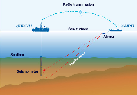
Vertical Seismic Profiling is a technique used to measure geological formations of plate boundaries and accretionary prisms with a great precision. It involves some 20 seismometers being lowered from the CHIKYU into the borehole, toward which elastic waves are fired from an air gun towered by the JAMSTEC´s research vessel KAIREI (Fig.4).
- Figure 1: Map of study area and drilling Sites

- Figure 2: Riser system (left) and Riserless system (right)
- Figure 3 : Schematic sketch of fairing
- Figure 4: Schematic sketch of VSP at NT2-11
- Photo 1: Lowering of riser pipe
- Photo 2: Attachment of fairing
Contacts:
- (For the expeditions)
-
TakeoTanaka, e-mail: cdex@jamstec.go.jp
Manager, Planning and Coordination Department
Center for Deep Earth Exploration (CDEX)
Japan Agency for Marine-Earth Science and Technology
- (For Publication)
-
Noriyuki Murata, e-mail: press@jamstec.go.jp
Manager, Planning Department Press Office
Japan Agency for Marine-Earth Science and Technology