March 9, 2012
JAMSTEC
Integrated Ocean Drilling Program (IODP)
Chikyu to Set Sail for Expedition 343: Japan Trench Fast Drilling Project (JFAST)
The Deep-Sea Scientific Drilling Vessel Chikyu, operated by the Japan Agency for Marine-Earth Science and Technology (JAMSTEC), will embark on Integrated Ocean Drilling Program (IODP)*1 Expedition 343 Japan Trench Fast Drilling Project (JFAST), from 1 April to 24 May 2012.
*1. The Integrated Ocean Drilling Program (IODP) is an international marine research drilling program dedicated to advancing scientific understanding of the Earth by monitoring and sampling subseafloor environments. Through multiple platforms, scientists explore IODP's principal themes: the deep biosphere, environmental change, and solid Earth cycles. IODP has been in operation since October 2003, funded jointly by the Japan Ministry of Education, Culture, Sports, Science and Technology and by the U.S. National Science Foundation. Additional support is provided by the 18-member European Consortium of Ocean Research Drilling, the People's Republic of China, the Republic of Korea, Australia, India, and New Zealand.
Appendix
Integrated Ocean Drilling Program
Japan Trench Fast Drilling Project (JFAST)
Importance for Understanding the Devastating Tsunami from the 2011 Tohoku Earthquake
The main goal of the JFAST project is to understand the very large fault slip that occurred on the shallow portion of the subuction zone during the 2011 Tohoku earthquake. This large slip of 30 to 50 meters was the main source of the devastating tsunami that caused so much damage and loss of lives along the northeast coast of Honshu, Japan. Understanding the Tohoku earthquake and tsunami has obvious consequences for evaluating the hazards at other subduction zones around the world.
Past thinking was that the plate-boundary fault zone in the region of the accretionary wedge near the trench has weak strength, so that large stress does not accumulate during the time before the earthquake. This means that large slip is not expected when the great subduction earthquakes occur. The 2011 Tohoku earthquake (Magnitude 9.0) off the Pacific coast of Japan has shown this is not always the case.
In order to understand how the fault moved with such large displacement in this region, the JFAST project has two main objectives. The first is to sample the fault in order to analyze the physical properties of the fault zone. The second is to make temperature measurements to estimate the frictional stress during the earthquake.
Obtaining a piece of the fault that moved tens of meters during the earthquake will provide meaningful new geological information. Scientists have never seen samples of a fault that has moved such a large amount during a recent earthquake. Detailed studies of the physical properties, fluid conditions, and frictional sliding characteristics will be done to understand the fault process during the earthquake.
Clarifying the stress conditions for the shallow portion of the plate-boundary thrust is an important seismological issue for this and all earthquakes. The key to understanding the dynamics of large ruptures is to know the level of dynamic friction on the fault. One of the most direct ways to estimate the fault friction during the earthquake is to measure the residual heat at the fault zone. Theoretical calculations show that measurements need to begin within about 2 years following the earthquake in order to accurately resolve the diminishing temperature signal. Several important time-sensitive measurements are needed for reliable estimates of friction, including the fault temperature, fault zone permeability, and chemical properties of the fluids and rock. Thus the name of the project, JFAST.
Expedition 343 (JFAST) of the Integrated Ocean Drilling Program (IODP), requires a particularly rapid mobilization of IODP research facilities to measure the time-dependent properties. Expedition team members will soon board the state-of-the-art scientific drilling vessel Chikyu to meet the challenge of drilling to the fault zone of the Tohoku earthquake.
The drilling site is located off Oshika Peninsula, just west of the axis of the Japan Trench. The water depth at the primary drill site is 6,910 meters, and Chikyu will drill as much as 1000 meters below the seafloor to reach the fault zone. In the history of deep sea drilling projects, only one other expedition has successfully drilled at greater water depth, and that was at 7,034 meters in the Mariana Trench in 1978; however, in the Mariana expedition the drilling only sampled to 15.5 meters below the seafloor. The present expedition to the Japan Trench will use about 8,000 meters of drill string and is thus a great scientific, engineering, and record-setting challenge.
The main operations to be completed during the expedition consist of drilling two boreholes at a single location; the first hole is dedicated to collecting downhole geophysical data to determine in situ stress and locate the fault zone, and the second hole is dedicated to retrieving core samples from across the Tohoku earthquake slip surface. Each hole will be completed with an observatory deployment comprised of a suite of temperature and pressure sensors. At the first hole, a measurement string containing 55 miniature temperature loggers will be suspended in the borehole and attached to the wellhead. In the second hole, a measurement string will be installed inside the casing with 21 thermistors along with fluid access ports outside of the casing, which will be used to measure pore fluid pressure inside and outside of the fault zone. Temperature and pressure data will be telemetered to a data logger at the wellhead. Observatory data from both boreholes will be retrieved by the JAMSTEC's Remotely Operated Vehicle (ROV) KAIKO 7000II.
Expedition schedule:
Chikyu will depart for the drilling and observatory installation expedition from Shimizu port on 1 April 2012
Completion of Expedition 343 at sea is expected on 24 May 2012
*The above schedule is subject to change depending on operational requirements or weather.
Drilling location:
220 km off Oshika Peninsula, Japan
Drill Site: Near the axis of Japan Trench (37°56'N, 143°55'E)
Water Depth 6,910 m, Target Depth (Below seafloor) 1,000 m
Scientific participants
Co-Chief Scientists:
James J. Mori, Professor, Kyoto University
Frederick M. Chester, Professor, Texas A&M University
Shipboard Science Party selected from IODP member countries includes 28 people from 10 countries.
More information about the expedition is available at http://www.jamstec.go.jp/chikyu/exp343/
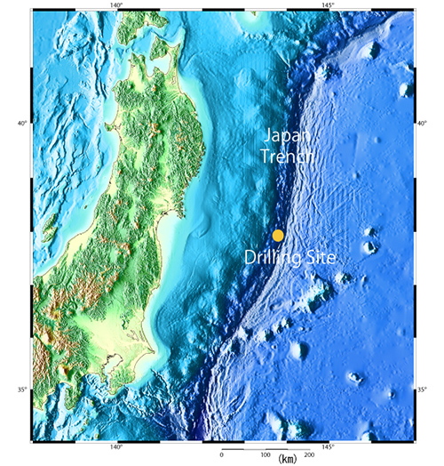
Figure 1: Drilling site
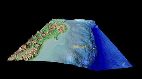
Figure 2:
3D image of sea floor topography and subsea floor structure at the drill site
(Water Depth 6,910m, 37°56'N, 143°55'E)

Figure 3: Conceptual image of sub-seafloor structure at the drill site
Contacts:
- Japan Agency for Marine-Earth Science and Technology
(For Chikyu) -
Yasuo Yamada, Manager
Planning and Coordination Department
Center for Deep Earth Exploration (CDEX)
- (For publication)
-
Hikaru Okutsu, e-mail: press@jamstec.go.jp
Senior Administrative Specialist, Planning Department Press Office