May 29, 2012
JAMSTEC
Sea ice retreat reduces Arctic Ocean low-level clouds
Overview
Team Leader Jun Inoue of the Japan Agency for Marine-Earth Science and Technology (JAMSTEC; Asahiko Taira, President), Research Institute for Global Change, Climate Dynamics Research Team and colleagues have used field observation data collected by the oceanographic research vessel Mirai to show that low-level clouds with a cloud base of below 500 meters occurring from summer to autumn over the Arctic Ocean have decreased 30% due to the sea-ice retreat.
Although low-level clouds (including fog) readily occur in sea ice regions, the results of this study show that as sea ice retreats, the supply of heat and water vapor from the sea surface increases and stratocumulus and other convective clouds with a relatively high cloud base develop more readily.
Because conventional satellite monitoring cannot be used to observe cloud base height over the Arctic Ocean, changes in this structure have been discussed by using numerical modeling. This study is the first to verify changes in vertical cloud structure accompanying sea ice retreat on the basis of field observation data.
These results will be published on May 31 in the American Geophysical Union's journal eophysical Research Letters. The results will also be introduced as a research highlight in the June issue of Nature Geoscience (published on May 29).
- Title:
- Impact of Arctic sea-ice retreat on the recent change in cloud-base height during autumn
- Authors:
- Kazutoshi Sato1,2, Jun Inoue1, Yasumasa Kodama2, James E. Overland3
Affiliations:
- 1.
- Climate Dynamics Research Team, Research Institute for Global Change, Japan Agency for Marine-Earth Science and Technology, Yokosuka, Japan
- 2.
- Graduate School of Science and Technology, Hirosaki University, Hirosaki, Japan
- 3.
- National Oceanic and Atmospheric Administration/Pacific Marine Environmental Laboratory (NOAA/PMEL), Seattle, Washington, USA
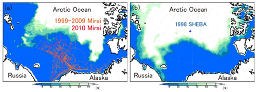
Figure 1 Ice concentration on (a) September 2010 with all Arctic cruise tracks by R/V Mirai from 1999 to 2010, and (b) September 1998 with SHEBA station.
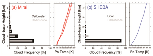
Figure 2 Frequency distribution of Arctic cloud base height in autumn.
(a) Observation results north of latitude 75°N in ice free areas (average of 8 years of R/V Mirai cruises), (b) Observation results in sea ice area (1998 SHEBA project). Radiosonde: grey, ceilometer /Lidar: Black
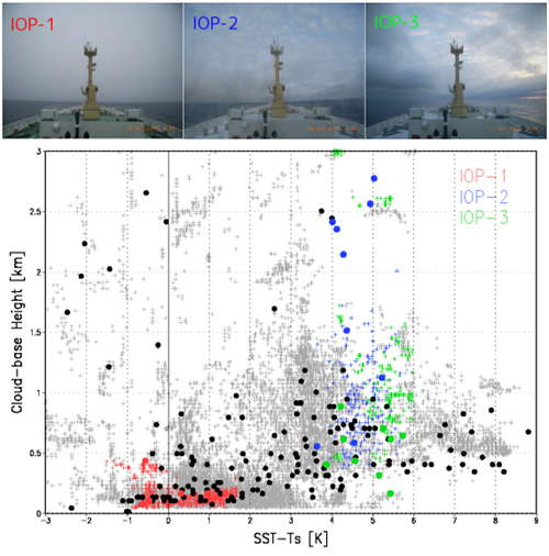
Figure 3 Scatter diagram of 2010 R/V Mirai Arctic Ocean observations of differences between sea surface temperature and air temperature above the ocean (SST-Ts) and cloud base height. Radiosonde (•) and ceilometer (+) results.
Low clouds prevail when SST-Ts are small and higher clouds prevail with larger SST-Ts. Red, blue, and green marks show the intensive observation periods (IOP) conducted on the latitude 71°N to 75°N, longitude 162°W line. The photographs above show the cloud situation during those periods. Low clouds were observed during IOP-1 with small temperature differences, while high clouds were seen during IOPs-2 and 3 when temperature differences were large. A 3°C temperature difference is the boundary, with stratiform clouds forming at lower temperature differences and convective clouds forming at higher temperature differences.
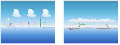
Figure 4 Differences in cloud structure over ocean without sea ice and with sea ice (schematic diagram).
Heat supply from the sea surface increases with retreat of sea ice and clouds with a high cloud base become prominent.
Contacts:
- Japan Agency for Marine-Earth Science and Technology
(For the study) - Jun Inoue, Team Leader
Climate Dynamics Research Team
Research Institute of Global Change(RIGC) - (For publication)
- Kazushige Kikuchi, Director
Planning Department, Press Office
Email: press@jamstec.go.jp