
 Typhoon Haiyan: The Super Typhoon that Struck the Philippines in November 2013
Typhoon Haiyan wreaked serious havoc in the Philippines. It is imperative to analyze the mechanisms of this typhoon using numerical models, and make recommendations for future forecasting as well as disaster policies and responses. For these reasons, we give an explanation of Typhoon Haiyan below.
We also take this opportunity to express our sincerest sympathies for the victims of Typhoon Haiyan as well as their families, and are deeply sorry for their losses. We are praying for the recovery of the affected areas without any further delay.
Typhoon conditions of fall 2013
In the fall 2013, the northwest Pacific Ocean saw a large number of typhoon occurrences. It is known that on average, four to five typhoons occur in September, and three to four in October. However, eight typhoons occurred in September last year, six in October, and two in November. This makes for the largest number of typhoons on record since September.
How did it reach land with so much force?
The following two mechanisms emerge when we analyze the reasons for the consecutive occurrence of the typhoons in the fall last year, and why such a powerful typhoon descended upon the Philippines. Some factors also relate to why the number of typhoons was so high.
- 1)
- The continuous state of high ocean temperature along with the mixed layer of the ocean, which occurred in the equatorial zone of the northwest Pacific Ocean including the area of ocean east of the Philippines. This increases the amount of vapor in the air, which fosters the development of typhoons. From September to October, the conditions of unusually high water temperatures were persistent in the equatorial zone (satisfying the standard condition for typhoon occurrences, which is said to be 28–29°C). Additionally, the high temperature conditions of the mixed layer of the ocean were also noteworthy during the beginning of November, when Typhoon Haiyan occurred. Therefore, the typhoon that occurred in the equatorial zone maintained its force and continued advancing toward the northwest. The typhoon touched down in the Philippines and resulted in serious damage.
- 2)
- The continuous state of the high-pressure system in the center of the Pacific Ocean. Typhoons move along the western side of this high-pressure system toward Japan. Last year, the continuous state of the high ocean water temperatures offshore in the Philippines which is discussed above, created a rising air current. The downward course of the risen air in the vicinity of the high-pressure system was persistent. In order to create the vortex of a typhoon, there must be triggering disturbances such as wave and swirl motion of air. The source of the rising air current offshore of the Philippines coincides with the continuous projection of the monsoon trough – an assembly of low-pressure systems – towards the east coast of the Philippines.
Why were the tides so high?
The high tides can be explained from seawater that has drifted toward the coast due to strong winds, known as the "drift effect," and the low pressure on the ocean's surface known as the "inverse barometer effect." The former effect increases in proportion to the square of the wind velocity. It is thought that damage from high tides increased since the wind velocity of Typhoon Haiyan reached 90 m/s at its highest point, putting it in the strongest class of typhoons last year. It is also important to note that the typhoon was moving at a relatively fast speed (typically the speed for many typhoons in the tropics is 5–6 m/s, although in the case of Typhoon Haiyan, it was moving at approximately 9–10 m/s one to two days before it reached shore). Accordingly, regions which suffered a great amount of damage, such as Leyte Island, were hit by the wind system occurring in the typhoon's northeast quadrant. Here it is presumed that the effect of the speed of the typhoon was coupled with the effect of the wind velocity of the typhoon itself, expanding the damage from high tide as waves from the ocean's surface blew inland.
Typhoon Haiyan is similar to Ise-wan Typhoon, in that its power was such so as to hit coastal lowlands especially hard and wreak serious havoc due to high tides. Ise-wan Typhoon occurred in September of 1959, and caused serious damage to Mie and Aichi Prefectures.
Recommendations for future typhoon forecasting research and disaster policies and responses
As described above, increases in the ocean's temperature and the amount of heat it stores, which cause typhoons to become violent, top the list of natural phenomena that accompany global warming. The Fifth Assessment Report announced in September last year by the Intergovernmental Panel on Climate Change (IPCC), also concluded that ocean temperatures would rise by an estimated 0.11°C per decade. Therefore, it is likely that the force of tropical low-pressure systems, including typhoons, will continue to grow stronger in the future.
We can ensure quantitative and reliable data necessary for disaster prevention protocols only when the three main issues of typhoon prediction – occurrence, route, and intensity – can be forecast with a high level of precision. It goes without saying that the important thing in achieving this is the expansive application of large-scale computers, such as Earth Simulator, as well as numerical weather models with the high degree of accuracy needed for prediction. At JAMSTEC, we have developed proven simulation models which can reproduce tropical climate and weather – the key to typhoon prediction. We are also continually developing models that have the potential for detailed predictions of, for example, how cities can continue their operations if Japan were struck by a typhoon. These models are about to be put to use for future development of prediction research. The expectations of the IPCC and other related projects are high. The goal of JAMSTEC typhoon researchers is to combine their models and prediction development capabilities, and to discover new terrains in model-based prediction centered on typhoons.
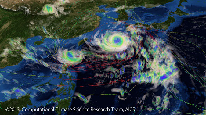
Example of Typhoon Prediction: The results of simulation of Typhoon Bolaven, one of the largest typhoons that hit Okinawa on August, 25 2012, using the NICAM 3.5 km-mesh model (showing the cloud-water mixing ratio and flow fields).
Model: NICAM GCSRAM
The picture is provided by Ryuji Yoshida, Computational Climate Science Research Team, Advanced Institute for Computational Science, RIKEN.
Kazuyoshi Oouchi
Advanced Atmosphere-Ocean-Land Modeling Program,
Research Institute for Global Change