Press Releases
JAMSTEC
Data assimilation using high-frequency radar for tsunami early warning: A case study of the 2022 Tonga volcanic tsunami
1. Key Points
- ◆
- The tsunami triggered by the 2022 Tonga volcanic eruption was detected and observed using high-frequency radar (*1) installed in the eastern Tsugaru Strait.
- ◆
- Tsunami data assimilation (*2) was conducted using the sea surface current velocity observed by the high-frequency radar.
- ◆
- Compared to the results using an offshore bottom pressure gauge network, the results using high-frequency radar had over 20% higher accuracy in coastal tsunami forecasting.
【Terminology】
- *1.
- High-frequency radar is a remote sensing instrument that uses shortwave radio waves to observe currents and waves on the sea surface, for several tens of kilometers offshore, from antenna base stations on land. For information on high-frequency radar system in the Tsugaru Straits, see
MORSETS (https://www.godac.jamstec.go.jp/morsets/j/top/index.html)
- *2.
- Data assimilation is a method of combining real observations with numerical simulation and using the observations to improve the certainty of simulated results.
2. Introduction
Dr. Yuchen Wang, a Young Research Fellow at Japan Agency for Marine-Earth Science and Technology (JAMSTEC; President: Dr. Hiroyuki Yamato), Research Institute for Marine Geodynamics, Research and Development Center for Earthquake and Tsunami Forecasting, and his colleagues proposed a tsunami data assimilation method using high-frequency (HF) radar observations. They used the tsunami generated by the eruption of the Hunga Tonga–Hunga Ha’apai volcano on January 15, 2022, as a case study. They applied this method to forecast coastal tsunamis and verify the accuracy.
JAMSTEC has installed high-frequency radars at three locations in the eastern Tsugaru Strait, to observe the sea surface current in the Tsugaru Strait since April 2014 (Press release on September 17, 2015; Figure 1). Although the initial goal of these radars was to understand the response of the Tsugaru Strait environment to global environmental changes, the observation data of sea surface current direction and velocity can be applied to tsunami forecasting. This study used the example of the 2022 Tonga volcanic tsunami to test this method.
Combining HF radar observation with numerical simulation results in a more than 20% improvement in the accuracy of forecasting the maximum amplitude of coastal tsunamis, compared to the results using an offshore bottom pressure gauge (OBPG) network. The possible reason is that HF radar captures detailed tsunami amplitude variations caused by the complex topography of the Tsugaru Strait coastal area.
In this case study, we obtained results that improved the accuracy of tsunami forecasting in coastal areas. However, compared to OBPG network that can observe tsunamis in real time continuously, HF radar system has limited observational range and sampling intervals. In the future, we expect that the combination of the two systems enables more effective tsunami early detection and more accurate forecast of coastal tsunamis.
This study will be published in the Journal of Geophysical Research: Solid Earth on January 31, 2022 (JST).
- Yokohama Institute for Earth Sciences, Japan Agency for Marine–Earth Science and Technology, Kanazawa-ku, Yokohama, Kanagawa 236-0001, Japan
- Prediction Science Laboratory, RIKEN Cluster for Pioneering Research, Chuo-ku, Kobe, Hyogo 650-0047, Japan
- Mutsu Institute for Oceanography, Japan Agency for Marine–Earth Science and Technology, Mutsu, Aomori 035-0022, Japan
- Faculty of Fisheries Sciences, Hokkaido University, Hakodate, Hokkaido 041-8611, Japan
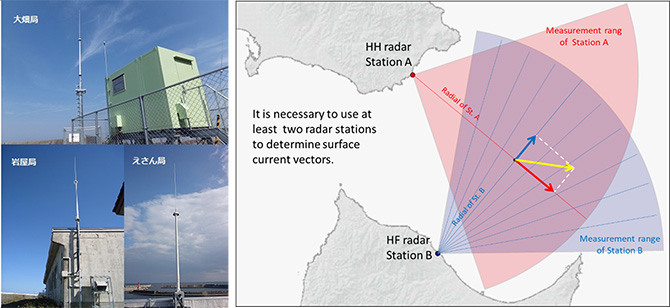
Figure 1. High-frequency radar antenna base stations (left) and functional schematic diagram (right).
3. Background
Tsunami forecasting using data assimilation is a method of tsunami early warning. This method directly utilizes offshore tsunami observations (direction, velocity, height, etc.) and combines them with numerical simulation. It reconstructed the tsunami wavefield in the vicinity of the observation network and used the reconstructed wavefield as the initial condition for numerical simulation. Unlike quantitative tsunami forecasting (*3) used by the Japan Meteorological Agency, which is based on seismic observations, this forecasting method does not require tsunami source information.
Previous studies on tsunami data assimilation for early warning were mostly based on real-time OBPG networks, such as the Dense Oceanfloor Network system for Earthquakes and Tsunamis (DONET) and the seafloor observation network for earthquakes and tsunamis along the Japan Trench (S-net; Figure 2; *4), which observe tsunami height. Other information such as the sea surface current velocity in a spatial domain can also be applied to tsunami data assimilation. HF radar observes tsunamis from the coastal to offshore areas in a spatial domain; therefore, it is promising for tsunami data assimilation. In this study, we test the method using the example of the tsunami triggered by the Tonga volcanic eruption.
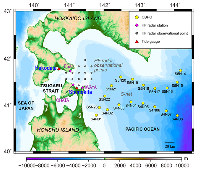
Figure 2. Bathymetry of offshore bottom pressure gauge (OBPG) network S-net and high-frequency (HF) radar. Yellow circles: S-net OBPGs; magenta diamonds: HF radar land stations; gray circles: selected HF radar observational points for data assimilation; and red triangles: coastal tide gauges.
4. Results
【Terminology】
- *3:
- Quantitative tsunami forecasting.
(https://www.data.jma.go.jp/eqev/data/tsunami/ryoteki.html)
- *4:
- DONET is an earthquake and tsunami observation system in Kumano Nada and Kii Channel. https://www.seafloor.bosai.go.jp/DONET/
S-net is a seafloor observation network for earthquakes and tsunamis along the Japan Trench. https://www.seafloor.bosai.go.jp/S-net/
The data observed by seismometers and water pressure gauges on the seafloor was transmitted to land stations via submarine cable. Therefore, real-time observation is achieved.
OBPG network (S-net) and HF radar observations from 18:00 to 24:00 JST on January 15, 2022, were used for data assimilation. After 24:00, the tsunami simulations were performed using the wavefield reconstructed by data assimilation as the initial condition. Observations at the Shimokita and Hakodate tide gauges were used to verify the accuracy.
The tsunami triggered by the eruption of the Hunga Tonga–Hunga Ha’apai volcano was observed by OBPG network from 20:00 JST (Figure 3). Evident variations in the sea surface current were also observed by the HF radar installed in the Tsugaru Strait (Figure 4).
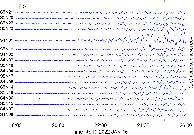
Figure 3. Tsunami height observed by offshore bottom pressure gauge network. The tsunami signals were extracted by removing tidal components from the observations.
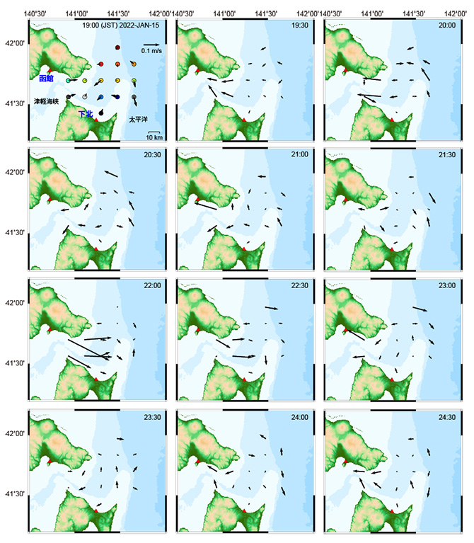
Figure 4. Sea surface current velocity observed using high-frequency radar. The tsunami signals were extracted by removing tidal components from the observations.
When the assimilation results using OBPG were adopted as the initial conditions, the waveforms at Shimokita on the Pacific coast were accurately predicted, but those at Hakodate on the coast of the Tsugaru Strait were underestimated (Figure 5a). When the assimilation results using HF radar were adopted as the initial condition, despite some noise, the tsunami amplitude at Shimokita and the oscillation signals in the Tsugaru Strait were successfully reproduced, consistent with the observations (Figure 5).
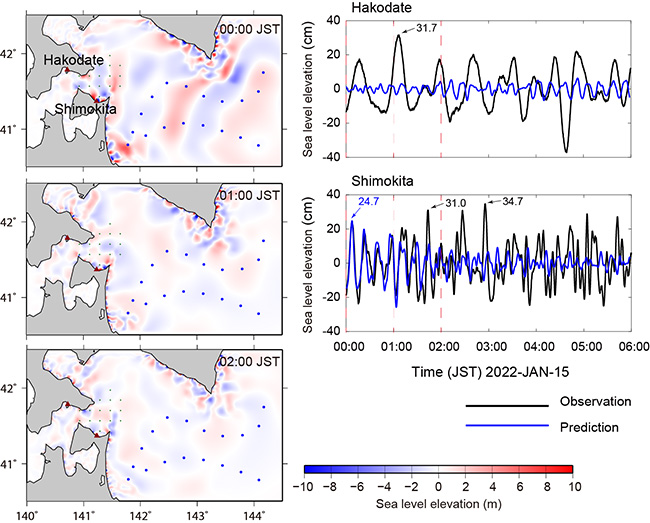
(a) By using OBPGs
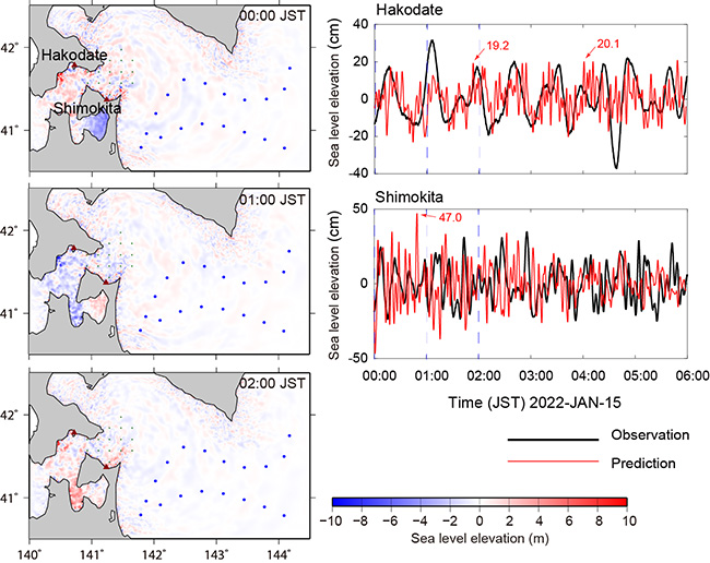
(b) By using HF radar
Figure 5. Tsunami forecasting results based on data assimilation from 18:00 to 24:00 JST using offshore bottom pressure gauges network (a) and high-frequency radar (b). Secondary undulation (*5) with period of 30 min were observed at Hakodate. The waveforms forecasted by data assimilation using offshore bottom pressure gauge matched well with observations at Shimokita, which faces the open ocean, but did not match well with observations at Hakodate inside the Tsugaru Strait. High-frequency radar has a large sampling interval (30 min), and the noise was evident. However, it was capable of forecasting the tsunami amplitude at Shimokita as well as the oscillation signals in the Tsugaru Strait.
The accuracy of the maximum tsunami amplitudes in the next 2 and 6 h after the forecasting was calculated for quantitative evaluation. For the next 2 h, the average accuracy of the two coastal stations was 47% for the OBPG and 63% for the HF radar. Over the next 6 h, the accuracies were 46% and 70%, respectively. Data assimilation using OBPG had a comparatively lower forecasting accuracy due to the complex bay topography. Data assimilation using HF radar, which monitors tsunamis from coastal to offshore areas, is useful for tsunami forecasting.
5. Future Work
In this study, the effectiveness of tsunami forecasting via data assimilation using HF radar was demonstrated based on the 2022 Tonga volcanic tsunami case. The OBPG network is crucial for tsunami early detection. However, tsunami forecasting by data assimilation using OBPG could be disadvantageous for coastal areas with bay topographies. Therefore, a more effective tsunami early warning can be achieved by incorporating HF radar, which monitors the sea surface current from coastal to offshore areas in a spatial domain.
HF radar has a few limitations. For example, the OBPG network has a sampling interval of a few seconds or shorter, whereas HF radar tuned for marine environment
【Supplementary Information】
- *5:
- Secondary undulation is the sea surface oscillations in the bay or strait. The period of oscillation ranges from several minutes to tens of minutes. It depends on the shape (depth, size) of the bay or strait.
observations has a sampling interval of several minutes or longer. The tsunami period was approximately 10–30 min; therefore, a sampling interval of several minutes was appropriate. However, shortening the sampling interval of HF radar leads to a decrease in the spatial coverage and observation accuracy. The sampling interval for monitoring the 2022 Tonga volcanic tsunami was 30 min, which was not sufficient considering the tsunami period.
In the future, it is necessary to investigate the optimal observation environment for tsunami data assimilation, including the HF radar observation settings (sampling interval, spatial resolution, and observation accuracy), observation conditions, and installation costs. A tsunami data assimilation method that interoperates between the OBPG and HF radars would be an important development.
Finally, HF radar systems are not limited to the eastern Tsugaru Strait but have been implemented in several coastal areas of the Japanese Islands. For example, an oceanic shortwave radar sea surface current distribution system (*6) has been deployed in Osaka Bay and Kii Channel. Combined operation with DONET is expected to provide more effective tsunami detection and accurate coastal tsunami forecasting, in preparation for potential earthquakes in the Nankai Trough. These R&D activities can also be extended to other coastal areas under potential tsunami threats, such as Indonesia and Chile.
【Supplementary Information】
- *6:
- This data is published for providing surface current observations by oceanic shortwave radar owned by the Kinki Regional Development Bureau and the Shikoku Regional Development Bureau of the Ministry of Land, Infrastructure, Transport and Tourism.
(http://www.kouwan.pa.kkr.mlit.go.jp/hf-radar/RealTime/main.asp)
contacts
- For this study
- Yuchen Wang, Young Research Fellow
Kentaro Imai, Deputy Group Leader [Researcher]
Research Institute for Marine Geodynamics (IMG)
Research and Development Center for Earthquake and Tsunami Forecasting (FEAT) Earthquake and Tsunami Monitoring Group, JAMSTEC
- For press release
- Press Office, Marine Science and Technology Strategy Department, JAMSTEC