JAMSTEC News
Application Laboratory, VAiG, JAMSTEC
[Column] A combination of an El Nino and a positive Indian Ocean Dipole Mode may occur in May
A La Niña event that continued over three years (2020-2022) finally disappeared this spring. A negative Indian Ocean Dipole Mode event also occurred in the tropical Indian Ocean for the three years, but it ended last winter. According to the latest forecast, a combination of an El Nino and a positive Indian Ocean Dipole Mode is likely to occur in May. Both the El Niño and the Indian Ocean Dipole Mode can cause abnormal weather around the world, including Japan. In particular, Indonesia and Australia (or East Africa) may experience an extremely wetter (or dryer)-than-normal condition.
A canonical-type El Niño event would be the first in seven years since the 2014–2016 event, a positive Indian Ocean Dipole Mode event would be the first in four years since the 2019 event, and a combination of the two events would be the first time in eight years since the 2015 event. In the summer and fall of 2015, Indonesia experienced an extremely drier-than-normal condition. Also in the summer of 2015, western Japan experienced low temperatures, while northern and eastern Japan experienced high temperatures from mid-July to early August and low temperatures from mid-August onward. Some of these complex regional variations may be due to the simultaneous occurrence of the El Niño and the Indian Ocean Dipole Mode events. We should keep a close eye on future developments in the tropical oceans.
What is an El Niño/La Niña?
This phenomenon is an ocean-atmosphere coupled phenomenon in the tropical Pacific Ocean, occurring every few years. When an El Niño event occurs, seawater temperatures are higher than normal in the eastern tropical Pacific Ocean and lower in the western region. This variation in ocean temperature could cause less rainfall in Indonesia and the Philippines. In addition, these tropical atmospheric variations could influence the mid-latitude climate remotely (called teleconnection), including Japan. On the other hand, a La Niña is the opposite of an El Niño, in which sea water temperatures are higher than normal in the western tropical Pacific Ocean and lower than normal in the eastern Pacific Ocean. This variation could cause more rainfall than normal in Indonesia and the Philippines. La Niña conditions continued in 2020, 2021, and 2022, but finally came to an end this spring. The impact of El Niño/La Niña events on weather and climate in remote areas is still being actively studied.
What is an Indian Ocean Dipole Mode?
This phenomenon is like an El Niño/La Niña, but seen in the tropical Indian Ocean. It occurs once every few years, from boreal summer to autumn. The Dipole Mode can have a positive or negative phase. When a positive event occurs, sea surface temperatures are warmer than normal in the western part of the tropical Indian Ocean and cooler in the eastern part. It could cause more rainfall in East Africa and, conversely, less rainfall around Indonesia and Australia. It can also bring hot summers and mild winters to western Japan. On the other hand, when a negative event occurs, sea surface temperatures are higher than normal in the southeastern tropical Indian Ocean and lower than normal in the western part. It can cause heavy rainfall and flood damage in Indonesia, while droughts are more likely to occur in East Africa. The impact of negative events on Japan is not yet well understood. In 2020, 2021, and 2022, negative Dipole Mode events occurred, and many parts of East Africa experienced severe droughts that threatened food and drinking water security. We have been developing the technology to predict these events in advance (For more information, see the press release “On the predictability of the extreme drought in East Africa during the short rains season ~Key roles of the negative Indian Ocean Dipole~”, Nature Research Highlight).
The impact of Dipole Mode events on weather and climate in remote areas and their relationships with El Niño/La Niña are still being actively studied.
Are an El Niño/La Niña and an Indian Ocean Dipole Mode predictable?
The dynamical seasonal prediction system called SINTEX-F by the Application Laboratory is skillful at predicting the occurrence of El Niño/La Niña events with high accuracy for more than one year using the supercomputer "Earth Simulator" (see the SINTEX-F website for details). In particular, we provide a 2-year lead forecast of El Niño/La Niña events on a monthly basis in quasi-real time. To our best knowledge, we are the only institute in the world that provides 2-year lead forecast information with such a long lead time (e.g. IRI, Columbia University). Although the accuracy of the forecasts decreases with longer lead times, we have published some pioneering scientific papers (e.g. Luo et al. (2008), Behera et al. (2020)) to show that the SINTEX-F is skillful at making such a long lead prediction in international journals.
Although it is difficult to predict Indian Ocean Dipole Mode events a few months in advance, the SINTEX-F has many successful results in predicting their occurrence (e.g., it successfully predicted the occurrence of a very strong positive Dipole Mode event in 2019. For more information, see the press release "El Niño Modoki in the tropical Pacific Ocean was key to successfully predicting the 2019 Super Indian Ocean Dipole phenomenon ").
How is the latest forecast?
The SINTEX-F seasonal prediction system predicts that a combination of an El Nino and a positive Indian Ocean Dipole Mode may occur in May (Figures 1 and 2), although there is a large uncertainty in the predictions of the amplitude.
We should pay attention to how the tropical ocean is going, which could cause extreme weather and climate events in the world. The SINTEX-F seasonal forecasts are updated monthly. Please refer to the SINTEX-F homepage and the APL Virtualearth for the latest information.
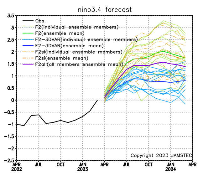
Figure 1: Monthly El Niño index (Nino3.4, the sea surface temperature deviations from the monthly mean climatology averaged over the domain of 170°W–120°W, 5°S–5°N) (°C) from the observational data of NOAA OISSTv2 (black) and the prediction issued on April 1, 2023 with the 36-member ensemble by the several versions of the the SINTEX-F (see the SINTEX-F website for details) and the all ensemble mean (thick purple). The ensemble mean shows the index will be above +0.5 °C from May to next year.
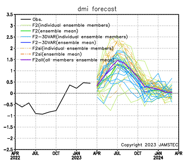
Figure 2: Same as Figure 1, but for the Indian Ocean Dipole Mode Index (DMI) is defined as the difference of the sea surface temperature deviations from the monthly mean climatology between the western pole off East Africa (50°E–70°E, 10°S–10°N) and the eastern pole off Sumatra (90°E–110°E, 10°S–Eq). The ensemble mean shows the index will be above +0.5 °C from May to October.