A new research program “Mathematical Seafloor Geomorphology” has been launched to establish a method to create a high resolution seafloor topography from the existing low resolution data by super-resolution using machine learning technology, and to merge the bottom topography pattern by feature extraction estimated for disaster prevention, environment, organisms, resources etc., aiming to perform quantitative evaluation and analysis, and to investigate the relationship between each field and bottom topography. Contribution to The Nippon Foundation – GEBCO Seabed 2030 Project is expected and will be performed under the program.
This research program concluded in March 2026.Creation of high resolution and high accuracy seafloor topography map by super resolution using machine learning method such as deep learning and Bayesian inference
Scheme IIExtraction of image feature quantity using machine learning
Scheme IIICollation of the image features with the data for each field to detect the underlying phenomenon that forms the seafloor topography
Special SchemeContribution to The Nippon Foundation-GEBCO Seabed 2030 Project
Bathymetry data acquired by the JAMSTEC are provided to four regional centres, which contribute to the annual production of GEBCO grid data.
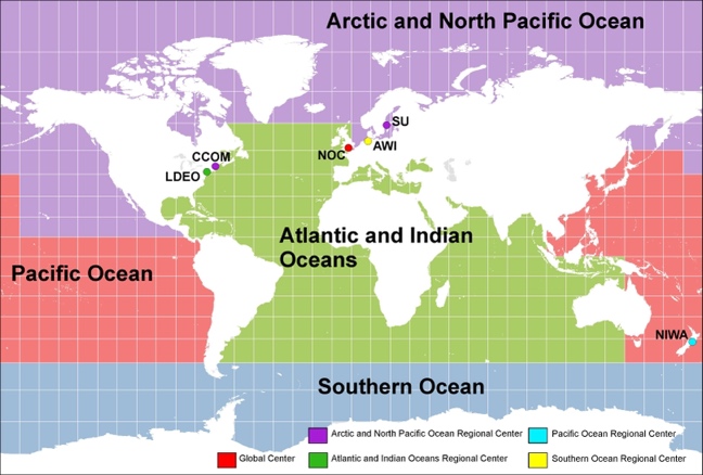
Location of The Nippon Foundation-GEBCO Seabed 2030 Project Global and Regional Centers, Data provided by a courtesy of Ms. Pauline Weatherall, National Oceanography Centre.
| FY | Recipient of offer | Number of cruises | Covered area |
|---|---|---|---|
| 2019 | NIWA, LDEO, IHO | MBES cruises | Pacific / Indian Ocean |
| 2020 | NIWA, LDEO, IHO |
After moratorium data 1.1GB(Compressed data) |
Pacific / Indian Ocean |
| 2021 | NIWA, LDEO, IHO |
MBES 82 cruises MBES 3 cruises |
Pacific / Indian Ocean |
| 2022 | NIWA Univ. NH IHO |
1.3GB (Compressed data) MBES 64 cruises After moratorium data |
Pacific Ocean North Pacific Region |
| 2023 | France HO NIWA IHO LDEO |
MBES 2 cruises MBES 38 cruises Track chart of all vessels After moratorium |
Sumatra area Pacific Ocean Atlantic Ocea |