


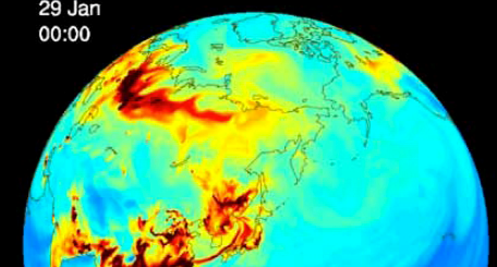
Severe weather phenomena that cause disasters, such as the Hiroshima heavy rainfall (August 2014) and the Kanto and Tohoku heavy rainfall (September 2015), occurred year after year in Japan. To reduce victims who have suffered from the local heavy rainfalls or wind gusts, their accurate forecasts including occurrence probabilities should be provided as early as possible. Namely, the accurate forecasts with the long leading time are needed. It is also important to clarify the impact of wind gusts on living space near the surface.
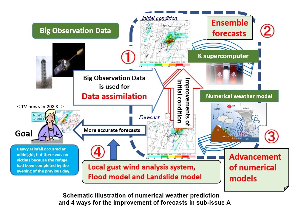
To obtain the accurate forecasts of rainfalls and wind speed, and their probabilities, the high-frequent and high-density observation data (Observation Big Data) that have been obtained by the recent highly-progressed observation technologies, and the developments of data assimilation techniques for ‘Observation Big Data’, which improve the initial conditions of numerical weather forecast models, are needed (Target 1). Furthermore, slight errors in initial conditions yield to the significant differences in the forecast, especially when there is no intense forcing such as fronts or when the forecast time becomes longer by going back to the initial time further. Namely, ensemble forecasts that provide the probabilities are essential to get the longer leading time.
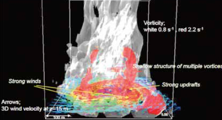
The possibilities of probability forecasts of floods and landslides are also investigated by applying the outputs of ensemble forecasts to flood/submersion models and debris flow models (Target 2). In addition, we are working toward enhancing the precision of the numerical weather forecast models by using K supercomputer (Target 3). The local wind gust analysis system is developed to clarify the characteristics of tornados and wind gusts in living space by using Large Eddy Simulation, a turbulence analysis technique, to mitigate damages (Target 4).
Taking these four types of approaches (Target 1-Target 4), we address issues of sub-issue A to substantially improve the prediction accuracy of local heavy rainfalls and wind gusts, and to get longer leading time with the aim of reducing victims of weather disasters, and to contribute the creating of a safer society by clarifying the impact of weather phenomena on buildings in living space near the surface.
*Leading time: Time from announcement of weather prediction to occurrence of a weather phenomenon. People have to evacuate during this time period.
To obtain the accurate forecasts of rainfalls and wind speed, and their probabilities, the high-frequent and high-density observation data (Observation Big Data) that have been obtained by the recent highly-progressed observation technologies, and the developments of data assimilation techniques for ‘Observation Big Data’, which improve the initial conditions of numerical weather forecast models, are needed (Target 1). Furthermore, slight errors in initial conditions yield to the significant differences in the forecast, especially when there is no intense forcing such as fronts or when the forecast time becomes longer by going back to the initial time further. Namely, ensemble forecasts that provide the probabilities are essential to get the longer leading time.
The possibilities of probability forecasts of floods and landslides are also investigated by applying the outputs of ensemble forecasts to flood/submersion models and debris flow models (Target 2). In addition, we are working toward enhancing the precision of the numerical weather forecast models by using K supercomputer (Target 3). The local wind gust analysis system is developed to clarify the characteristics of tornados and wind gusts in living space by using Large Eddy Simulation, a turbulence analysis technique, to mitigate damages (Target 4).
Taking these four types of approaches (Target 1-Target 4), we address issues of sub-issue A to substantially improve the prediction accuracy of local heavy rainfalls and wind gusts, and to get longer leading time with the aim of reducing victims of weather disasters, and to contribute the creating of a safer society by clarifying the impact of weather phenomena on buildings in living space near the surface.
*Leading time: Time from announcement of weather prediction to occurrence of a weather phenomenon. People have to evacuate during this time period.
Sub-issue A
Videos of achievements
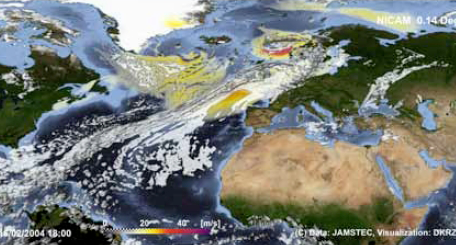
Performed Large Eddy Simulation (LES) which can represent microstructure in a region covering the entire typhoon area by using the Japan Meteorological Agency’s Non-Hydrostatic Model (JMANHM), and created a three-dimensional visualization of a mass of water from a cross-sectional view of the center of the simulated typhoon.
Some Sub-issue
Sub-issue A
Sub-issue B
Sub-issue C
Co-Design

Severe weather phenomena that cause disasters, such as the Hiroshima heavy rainfall (August 2014) and the Kanto and Tohoku heavy rainfall (September 2015), occurred year after year in Japan. To reduce victims who have suffered from the local heavy rainfalls or wind gusts, their accurate forecasts including occurrence probabilities should be provided as early as possible. Namely, the accurate forecasts with the long leading time are needed. It is also important to clarify the impact of wind gusts on living space near the surface.
To obtain the accurate forecasts of rainfalls and wind speed, and their probabilities, the high-frequent and high-density observation data (Observation Big Data) that have been obtained by the recent highly-progressed observation technologies, and the developments of data assimilation techniques for ‘Observation Big Data’, which improve the initial conditions of numerical weather forecast models, are needed (Target 1). Furthermore, slight errors in initial conditions yield to the significant differences in the forecast, especially when there is no intense forcing such as fronts or when the forecast time becomes longer by going back to the initial time further. Namely, ensemble forecasts that provide the probabilities are essential to get the longer leading time.
The possibilities of probability forecasts of floods and landslides are also investigated by applying the outputs of ensemble forecasts to flood/submersion models and debris flow models (Target 2). In addition, we are working toward enhancing the precision of the numerical weather forecast models by using K supercomputer (Target 3). The local wind gust analysis system is developed to clarify the characteristics of tornados and wind gusts in living space by using Large Eddy Simulation, a turbulence analysis technique, to mitigate damages (Target 4).
Taking these four types of approaches (Target 1-Target 4), we address issues of sub-issue A to substantially improve the prediction accuracy of local heavy rainfalls and wind gusts, and to get longer leading time with the aim of reducing victims of weather disasters, and to contribute the creating of a safer society by clarifying the impact of weather phenomena on buildings in living space near the surface.
*Leading time: Time from announcement of weather prediction to occurrence of a weather phenomenon. People have to evacuate during this time period.
Sub-issue A
Videos of achievements
Performed Large Eddy Simulation (LES) which can represent microstructure in a region covering the entire typhoon area by using the Japan Meteorological Agency’s Non-Hydrostatic Model (JMANHM), and created a three-dimensional visualization of a mass of water from a cross-sectional view of the center of the simulated typhoon.