


In 2015, Earth experienced the highest surface air temperature on global average in conjunction with a massive El Niño event. In the North Hemisphere, super typhoons, typhoons with Category 4 or more, are frequently generated, and the number of their occurrences reached a record high. In Japan, Typhoons No. 17 and 18 and, after their passage, an extratropical cyclone brought heavy rainfall, resulting in flooding of the Kinugawa River and other disasters. The news about the “2015 September heavy rainfall disaster in Kanto and the Tohoku area” is still fresh in our memory. If a super typhoon hits Japan in the near future, rainstorms are likely to cause severe damage. To address this, it is necessary to provide forecast information with a longer lead time.
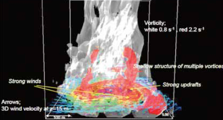
Operational numerical weather prediction predicts the weather for a week, but has not yet reached the point where it predicts typhoons and other weather events further ahead. In sub-issue B, with the post-K supercomputer in mind, we are developing numerical simulation system which predicts weather and climate variations covering from several weeks to seasons and a year in a seamless manner and exploring the predictability of weather and climate phenomena. In particular, we are studying the predictability of typhoons for more than a week by substantially increasing resolution and the number of ensembles of numerical prediction models. We are also improving performance of numerical simulation with the aid of big data from earth observation satellites.
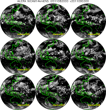
Typhoon ensemble prediction simulated by NICAM, a global cloud resolving model
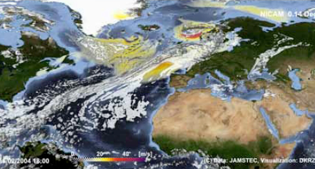
Performed a 30-year long term climate simulation with 14-km horizontal resolution by using NICAM, a global cloud resolving model, on K supercomputer. The video shows clouds and rainfall in February. Taking a closer look at Japan, it is well simulated that extratropical cyclones with a front hit Japan at intervals of four to five days and that, after frontal passage, it had been raining (snowing) on the Sea of Japan side in northern Japan.
Sub-issue A
Sub-issue B
Sub-issue C
Co-Design

In 2015, Earth experienced the highest surface air temperature on global average in conjunction with a massive El Niño event. In the North Hemisphere, super typhoons, typhoons with Category 4 or more, are frequently generated, and the number of their occurrences reached a record high. In Japan, Typhoons No. 17 and 18 and, after their passage, an extratropical cyclone brought heavy rainfall, resulting in flooding of the Kinugawa River and other disasters. The news about the “2015 September heavy rainfall disaster in Kanto and the Tohoku area” is still fresh in our memory. If a super typhoon hits Japan in the near future, rainstorms are likely to cause severe damage. To address this, it is necessary to provide forecast information with a longer lead time.
Operational numerical weather prediction predicts the weather for a week, but has not yet reached the point where it predicts typhoons and other weather events further ahead. In sub-issue B, with the post-K supercomputer in mind, we are developing numerical simulation system which predicts weather and climate variations covering from several weeks to seasons and a year in a seamless manner and exploring the predictability of weather and climate phenomena. In particular, we are studying the predictability of typhoons for more than a week by substantially increasing resolution and the number of ensembles of numerical prediction models. We are also improving performance of numerical simulation with the aid of big data from earth observation satellites.
Typhoon ensemble prediction simulated by NICAM, a global cloud resolving model
Performed a 30-year long term climate simulation with 14-km horizontal resolution by using NICAM, a global cloud resolving model, on K supercomputer. The video shows clouds and rainfall in February. Taking a closer look at Japan, it is well simulated that extratropical cyclones with a front hit Japan at intervals of four to five days and that, after frontal passage, it had been raining (snowing) on the Sea of Japan side in northern Japan.