November 16, 2007
The Japan Agency for Marine-Earth Science and Technology
Integrated Ocean Drilling Program (IODP)
Nankai Trough Seismogenic Zone Experiment (NanTroSEIZE)
Deep-Sea Drilling Vessel Chikyu
Successfully Completes
Expedition 314
1.Outline
The Japan Agency for Marine-Earth Science and Technology (JAMSTEC; Mr. Yasuhiro Kato, President) is pleased to announce that the Deep-sea Drilling Vessel Chikyu has just completed the first IODP expedition(*1), "Expedition 314" of the "Nankai Trough Seismogenic Zone Experiment (NanTroSEIZE)" as of November 15th.
2.Expedition 314 overview
Chikyu has spent 56 days carrying out scientific drilling in the Kumano basin off the Kii peninsula from September 21st to November 15th.
The primary goals of Expedition 314 were to obtain a comprehensive suite of geophysical logs and other downhole measurements at six sites across the Nankai accretionary complex using the most sophisticated logging while drilling (LWD)(*2) technology. Dr. Masataka Kinoshita (Group Leader of Deep Sea Research Group, Institute for Research on Earth Evolution, JAMSTEC) and Dr. Harold Tobin (Associate Professor, Department of Geology and Geophysics, University of Wisconsin-Madison, USA) are the Co-Chief Scientists, while the science party comprises 16 onboard scientists from 6 countries.
3.Primary results
Twelve boreholes were drilled at six sites. LWD drilling was conducted at five sites in the Nankai Trough accretionary complex off Kumano. Drilling conditions were severe at three sites due to strong deformation within the accretionary prism(*3), caused by plate convergence and by interseismic stress accumulation. Furthermore, operations were conducted within the strong Kuroshio Current, which was often stronger than 4 knots. However, with the drilling capability of Chikyu we successfully completed drilling down to 400 m to 1400 m below the sea floor and obtained high quality in-situ physical properties as well as borehole images. (For details, please refer to appendix)
Images of the borehole walls using electrical resistivity allow us to deduce the stress conditions at each drill site. We found that the stress condition and geologic structure of the uppermost 1-1.5km of accretionary prism is very different above seismogenic zone, between the thrust sheet above the mega-splay (Sites C0001 and C0004) and landward side of the Kumano forearc basin (Site C0002). These data are useful to infer the formation process of the accretionary prism and seismogenic mechanisms in the Kumano basin.
At Site C0002, we identified a methane hydrate-rich zone at 220 to 400 m below the sea floor based on high resistivity image and low gamma ray data. Hydrates are concentrated in sandy layers of numerous turbidites in this zone.
4. Following expeditions
The next NanTroSEIZE Expedition 315 has immediately begun starting November 16th. This expedition will revisit one of the sites (C0001) drilled during Exp314 and take continuous samples from the upper section of active accretionary prism sediment down to 1000m below the sea floor. It also serves as a pilot hole for the riser drilling to the Megasplay fault scheduled for next year.
(*1) Integrated Ocean Drilling Program (IODP)
The Integrated Ocean Drilling Program (IODP) is an international marine research drilling program dedicated to advancing scientific understanding of Earth by monitoring and sampling subseafloor environments. Through multiple platforms, preeminent scientists explore IODP principal themes: the deep biosphere, environmental change, and solid earth cycles. IODP has been operating since October 2003, led by Japan and the USA. IODP now has 21 member countries.
(*2) Logging While Drilling (LWD)
LWD is a technique to measure geological formation properties at a site while drilling, by attaching a physical measurement sensor near the drill bit.
Through continuous in-situ monitoring during drilling, geological data can be obtained quickly. It is necessary for drilling into complex geological structures, especially in the Nankai Trough, to acquire scientific geological data, and for the following coring operation, to have data on borehole conditions for safety monitoring and risk mitigation. Data expected to be obtained by LWD are formation density, porosity, velocity of sound speed, natural gamma ray, resistivity.
(*3)Nankai Trough Accretionary Prism
The Nankai Trough in Suruga Bay runs to off the coast of Tokai, the Kii Peninsula, Shikoku, and Kyushu, where the Philippine Sea Plate subducts under the west-south Japanese archipelago (Usually, ‘trough’ indicates a long thin ditch on the sea-floor, but here means ‘trench,’ one is approximately 770 km long). Along with this plate subduction, sediment on the plate is being scraped off and added to the continental plate, with such newly-formed geological sediments called “accretionary prism.” It’s development and history are very important in understanding the basic process of orogenesis, and front-line research is being conducted in the seismogenesis zone.
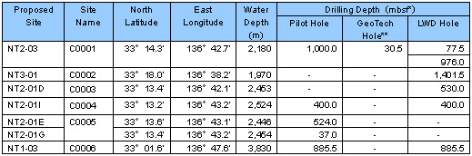
*mbsf: meters below the seafloo
**GeoTech Hole: Collect core samples to evaluate soil density for upcoming riser drilling
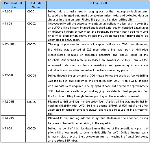
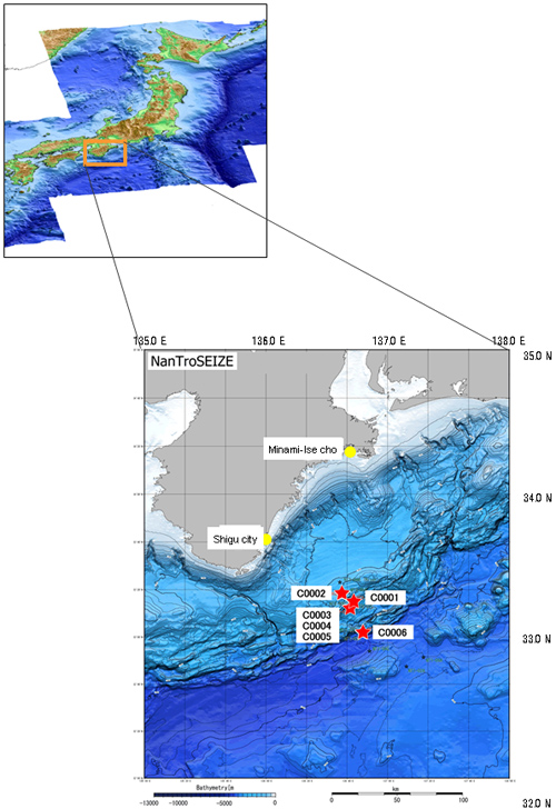
Figure 1:Survey Area
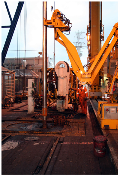
Figure 2:Descending LWD tools with various physical measurement sensors.
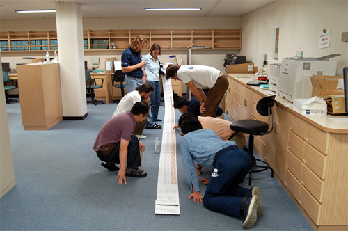
Figure 3:Scientists examining borehole data acquired by LWD.
Contacts:
- (For Chikyu)
- Mr. Takeo Tanaka, e-mail: cdex@jamstec.go.jp
Manager, Planning and Coordination Department
The Center for Deep Earth Exploration (CDEX)
Japan Agency for Marine-Earth Science and Technology
- (For Research)
- Dr. Harold Tobin, e-mail: htobin@wisc.edu
Co-Chief Scientist of Expedition 314
Associate Professor, Department of Geology and Geophysics
University of Wisconsin-Madison, USA -
Dr. Masataka Kinoshita, e-mail: masa@jamstec.go.jp
Co-Chief Scientist of Expedition 314
Group Leader of Ocean Bottom Observation Research Group
Institute for Research on Earth Evolution
Japan Agency for Marine-Earth Science and Technology
- (For Publication)
- Mr. Shinji Oshima, e-mail: press@jamstec.go.jp
Manager, Planning Department Press Office
Japan Agency for Marine-Earth Science and Technology